
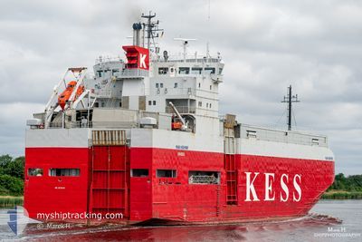
ERK IZMIR
Vehicles Carrier
Current Trip
| Time Travelled | 2 days |
|---|---|
| Remaining Time | --- |
| Distance Travelled | 855.47 nm |
| Remaining Distance | --- |
| AVG Speed | 13.4 Knots |
| MAX Speed | 17 Knots |
| AVG Wind | 14.1 knots |
| MAX Wind | 21 knots |
| MIN Temp | 11.7°C / 53.06°F |
| MAX Temp | 23.1°C / 73.58°F |
| Draught | 5.3 m |
| Position Received | 2 m ago |
Current Position
| Longitude | 0.71901° |
|---|---|
| Latitude | 36.95931° |
| Status | Under way using engine |
| Speed | 13.4 Knots |
| Course | 75° |
| Area | Mediterranean Sea - Western Basin |
| Station | T-AIS |
| Position Received | 2 m ago |
Info
Information
The current position of ERK IZMIR is in Mediterranean Sea - Western Basin with coordinates 36.95931° / 0.71901° as reported on 2024-06-21 19:55 by AIS to our vessel tracker app. The vessel's current speed is 13.4 Knots and is heading at the port of HAYDARPASA. The estimated time of arrival as calculated by vessel tracking app is 2024-06-26 19:00 LT
The vessel ERK IZMIR (IMO: 9179983, MMSI: 352002302) is a Vehicles Carrier that was built in 1998 ( 26 years old ). It's sailing under the flag of [PA] Panama.
In this page you can find informations about the vessels current position, last detected port calls, and current voyage information. If the vessels is not in coverage by AIS you will find the latest position.
The current position of ERK IZMIR is detected by our AIS receivers and we are not responsible for the reliability of the data. The last position was recorded while the vessel was in Coverage by the Ais receivers of our vessel tracking app.
The current draught of ERK IZMIR as reported by AIS is 5.3 meters
Weather
| Temperature | 22.4°C / 72.32°F |
|---|---|
| Wind Speed | 9 knots |
| Direction | 81° E |
| Pressure | 1019.4 hPa |
| Humidity | 77.4 % |
| Cloud Coverage | --- |
Featured Company
Last Port Calls
| Port | Arrival | Departure | Time In Port |
|---|---|---|---|
| 2024-06-18 11:08 | 2024-06-19 04:38 | 17 h | |
| 2024-06-13 07:31 | 2024-06-13 14:39 | 7 h | |
| 2024-06-12 19:04 | 2024-06-13 05:28 | 10 h | |
| 2024-06-06 02:16 | 2024-06-06 17:23 | 15 h | |
| 2024-05-20 06:16 | 2024-05-20 17:18 | 11 h | |
| 2024-05-13 14:36 | 2024-05-15 11:49 | 1 d | |
| 2024-05-09 05:21 | 2024-05-09 12:24 | 7 h | |
| 2024-05-02 12:20 | 2024-05-02 21:45 | 9 h | |
| 2024-04-08 03:46 | 2024-04-26 10:58 | 18 d | |
| 2024-04-03 22:17 | 2024-04-04 13:19 | 15 h |
Last Trips
| Origin | Departure | Destination | Arrival | Distance | |
|---|---|---|---|---|---|
| 2024-06-13 16:39 | 2024-06-18 13:08 | 609.48 nm | |||
| 2024-06-13 06:28 | 2024-06-13 09:31 | 13.44 nm | |||
| 2024-06-06 20:23 | 2024-06-12 20:04 | 1870.00 nm | |||
| 2024-05-20 20:18 | 2024-06-06 05:16 | 194.80 nm | |||
| 2024-05-15 13:49 | 2024-05-20 09:16 | 1345.96 nm | |||
| 2024-05-09 14:24 | 2024-05-13 16:36 | 365.67 nm | |||
| 2024-05-03 00:45 | 2024-05-09 07:21 | 1768.09 nm | |||
| 2024-04-26 13:58 | 2024-05-02 15:20 | 306.00 nm | |||
| 2024-04-04 16:19 | 2024-04-08 06:46 | 37.88 nm | |||
| 2024-03-28 05:56 | 2024-04-04 01:17 | 1839.57 nm |
Events
| Time | Event | Details | Position / Dest | Info |
|---|---|---|---|---|
| 2024-06-21 19:55 | Status Changed | Under way using engine Default |
36.95931 / .71901
TR HAY
|
Speed: 13.4 kn Course: 76° |
| 2024-06-21 19:05 | Status Changed | Default Under way using engine |
36.91050 / .49840
TR HAY
|
Speed: 13.1 kn Course: 74.2° |
| 2024-06-21 19:00 | Status Changed | Under way using engine Default |
36.90527 / .47579
TR HAY
|
Speed: 13.1 kn Course: 75° |
| 2024-06-21 18:53 | Status Changed | Default Under way using engine |
36.89839 / .44592
TR HAY
|
Speed: 13 kn Course: 74° |
| 2024-06-21 18:48 | Change Sea Area | Algerian part of the Mediterranean Sea - Western Basin Spanish part of the Mediterranean Sea - Western Basin |
36.89321 / .42351
Mediterranean Sea - Western Basin
TR HAY
|
Speed: 13 kn Course: 73.8° |
| 2024-06-21 18:48 | Status Changed | Under way using engine Default |
36.89253 / .42062
TR HAY
|
Speed: 12.9 kn Course: 74° |
| 2024-06-21 18:37 | IN Coverage |
36.89321 / .42351
Mediterranean Sea - Western Basin
TR HAY
|
Speed: 13 kn Course: 73.8° |
|
| 2024-06-21 11:35 | Status Changed | Default Under way using engine |
36.50494 / -1.49883
TR HAY
|
Speed: 13.8 kn Course: 76.4° |
| 2024-06-21 11:30 | Status Changed | Under way using engine Default |
36.50021 / -1.52439
TR HAY
|
Speed: 13.8 kn Course: 75° |
| 2024-06-21 11:30 | OUT of Coverage |
36.50021 / -1.52439
Mediterranean Sea - Western Basin
TR HAY
|
Speed: 13.8 kn Course: 76.4° |