
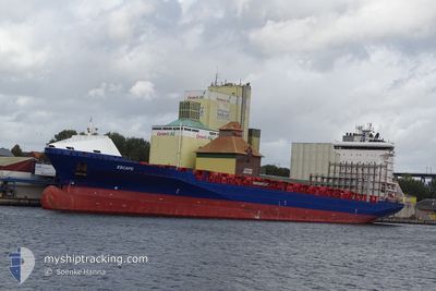
ESCAPE
Container Ship
Current Trip
| Time Travelled | 1 day |
|---|---|
| Remaining Time | 7 h, 42 mins |
| Distance Travelled | 294.42 nm |
| Remaining Distance | 66.99 nm |
| AVG Speed | 9.1 Knots |
| MAX Speed | 9.7 Knots |
| AVG Wind | 11 knots |
| MAX Wind | 20.8 knots |
| MIN Temp | 7°C / 44.6°F |
| MAX Temp | 12.9°C / 55.22°F |
| Draught | 10.2 m |
| Position Received | 1 m ago |
Current Position
| Longitude | 19.01434° |
|---|---|
| Latitude | 60.33373° |
| Status | Under way using engine |
| Speed | 8.9 Knots |
| Course | 359.9° |
| Area | Gulf of Bothnia |
| Station | T-AIS |
| Position Received | 1 m ago |
Info
Information
The current position of ESCAPE is in Gulf of Bothnia with coordinates 60.33373° / 19.01434° as reported on 2024-05-20 01:44 by AIS to our vessel tracker app. The vessel's current speed is 8.9 Knots and is heading at the port of GAVLE. The estimated time of arrival as calculated by vessel tracking app is 2024-05-20 09:27 LT
The vessel ESCAPE (IMO: 9491501, MMSI: 244255000) is a Container Ship that was built in 2011 ( 13 years old ). It's sailing under the flag of [NL] Netherlands.
In this page you can find informations about the vessels current position, last detected port calls, and current voyage information. If the vessels is not in coverage by AIS you will find the latest position.
The current position of ESCAPE is detected by our AIS receivers and we are not responsible for the reliability of the data. The last position was recorded while the vessel was in Coverage by the Ais receivers of our vessel tracking app.
The current draught of ESCAPE as reported by AIS is 10.2 meters
Weather
| Temperature | 7.1°C / 44.78°F |
|---|---|
| Wind Speed | 17 knots |
| Direction | 18° NNE |
| Pressure | 1017.7 hPa |
| Humidity | 73.8 % |
| Cloud Coverage | 20 % |
Featured Company
Last Port Calls
| Port | Arrival | Departure | Time In Port |
|---|---|---|---|
| 2024-05-18 03:49 | 2024-05-18 17:52 | 14 h | |
| 2024-05-16 17:52 | 2024-05-17 16:54 | 23 h | |
| 2024-05-14 02:19 | 2024-05-14 11:57 | 9 h | |
| 2024-05-11 14:52 | 2024-05-13 18:28 | 2 d | |
| 2024-05-08 05:36 | 2024-05-08 13:32 | 7 h | |
| 2024-05-05 09:56 | 2024-05-06 15:49 | 1 d | |
| 2024-05-03 16:18 | 2024-05-04 16:21 | 1 d | |
| 2024-05-02 01:56 | 2024-05-02 18:21 | 16 h | |
| 2024-05-01 08:04 | 2024-05-01 16:41 | 8 h | |
| 2024-04-28 13:13 | 2024-04-28 21:39 | 8 h |
Most Visited Ports (Last year)
| Port | Arrivals | |
|---|---|---|
| 24 | ||
| 24 | ||
| 22 | ||
| 14 | ||
| 12 | ||
| 12 |
Last Trips
| Origin | Departure | Destination | Arrival | Distance | |
|---|---|---|---|---|---|
| 2024-05-17 18:54 | 2024-05-18 06:49 | 146.97 nm | |||
| 2024-05-14 13:57 | 2024-05-16 19:52 | 493.61 nm | |||
| 2024-05-13 20:28 | 2024-05-14 04:19 | 115.74 nm | |||
| 2024-05-08 16:32 | 2024-05-11 16:52 | 1142.94 nm | |||
| 2024-05-06 17:49 | 2024-05-08 08:36 | 342.56 nm | |||
| 2024-05-04 18:21 | 2024-05-05 11:56 | 270.51 nm | |||
| 2024-05-02 21:21 | 2024-05-03 18:18 | 267.91 nm | |||
| 2024-05-01 18:41 | 2024-05-02 04:56 | 134.13 nm | |||
| 2024-04-28 23:39 | 2024-05-01 10:04 | 883.50 nm | |||
| 2024-04-28 06:32 | 2024-04-28 15:13 | 116.81 nm |
Events
| Time | Event | Details | Position / Dest | Info |
|---|---|---|---|---|
| 2024-05-20 00:50 | Change Sea Area | Swedish part of the Gulf of Bothnia Finnish part of the Gulf of Bothnia |
60.21151 / 19.09180
Gulf of Bothnia
LTKLJ>SEGVX
|
Speed: 8.4 kn Course: 333.5° |
| 2024-05-19 21:02 | Change Sea Area | Finnish part of the Gulf of Bothnia Finnish part of the Baltic Sea |
59.78890 / 19.77576
Gulf of Bothnia
LTKLJ>SEGVX
|
Speed: 8.8 kn Course: 320.9° |
| 2024-05-19 18:19 | Change Sea Area | Finnish part of the Baltic Sea Swedish part of the Baltic Sea |
59.44525 / 20.17177
Baltic Sea
LTKLJ>SEGVX
|
Speed: 9.6 kn Course: 354.7° |
| 2024-05-19 18:18 | Status Changed | Under way using engine Default |
59.44222 / 20.17228
LTKLJ>SEGVX
|
Speed: 9.6 kn Course: 355° |
| 2024-05-19 17:57 | Status Changed | Default Under way using engine |
59.38541 / 20.18141
LTKLJ>SEGVX
|
Speed: 9.4 kn Course: 355.5° |
| 2024-05-19 17:49 | Status Changed | Under way using engine Default |
59.36668 / 20.18416
LTKLJ>SEGVX
|
Speed: 9.4 kn Course: 356° |
| 2024-05-19 17:48 | Status Changed | Default Under way using engine |
59.36451 / 20.18443
LTKLJ>SEGVX
|
Speed: 9.4 kn Course: 355.4° |
| 2024-05-19 17:37 | Status Changed | Under way using engine Default |
59.33506 / 20.18835
LTKLJ>SEGVX
|
Speed: 9.4 kn Course: 356° |
| 2024-05-19 16:45 | Status Changed | Default Under way using engine |
59.19579 / 20.20281
LTKLJ>SEGVX
|
Speed: 9.7 kn Course: 357.6° |
| 2024-05-19 16:38 | Status Changed | Under way using engine Default |
59.17749 / 20.20426
LTKLJ>SEGVX
|
Speed: 9.6 kn Course: 358° |