
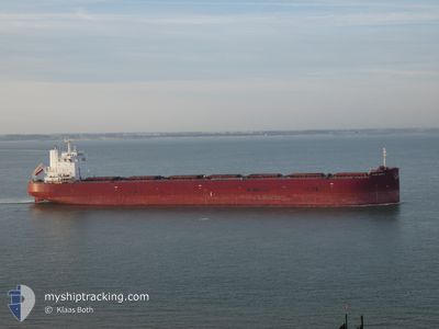
EVER GRACE
Cargo
Current Trip
| Trip Time | 6 days |
|---|---|
| Trip Distance | 829.49 nm |
| AVG Speed | 9.6 Knots |
| MAX Speed | 13.9 Knots |
| Draught | 10.5 m |
| AVG Wind | 8.9 knots |
| MAX Wind | 19.6 knots |
| MIN Temp | 7.4°C / 45.32°F |
| MAX Temp | 20.4°C / 68.72°F |
| Position Received | 4 d ago |
Current Position
| Longitude | -57.66643° |
|---|---|
| Latitude | -38.61275° |
| Status | Under way using engine |
| Speed | 12.1 Knots |
| Course | 242.7° |
| Area | South Atlantic Ocean |
| Station | T-AIS |
| Position Received | 4 d ago |
Info
Information
The current position of EVER GRACE is in South Atlantic Ocean with coordinates -38.61275° / -57.66643° as reported on 2024-06-04 19:43 by AIS to our vessel tracker app. The vessel's current speed is 12.1 Knots and is currently inside the port of BAHIA BLANCA.
The vessel EVER GRACE (IMO: 9750309, MMSI: 311000304) is a Cargo It's sailing under the flag of [BS] Bahamas.
In this page you can find informations about the vessels current position, last detected port calls, and current voyage information. If the vessels is not in coverage by AIS you will find the latest position.
The current position of EVER GRACE is detected by our AIS receivers and we are not responsible for the reliability of the data. The last position was recorded while the vessel was in Coverage by the Ais receivers of our vessel tracking app.
The current draught of EVER GRACE as reported by AIS is 10.5 meters
Weather
| Temperature | 17.7°C / 63.86°F |
|---|---|
| Wind Speed | 5 knots |
| Direction | 53° NE |
| Pressure | 1006.1 hPa |
| Humidity | 88.5 % |
| Cloud Coverage | 100 % |
Featured Company
Last Port Calls
Most Visited Ports (Last year)
| Port | Arrivals | |
|---|---|---|
| 2 | ||
| 1 | ||
| 1 | ||
| 1 | ||
| 1 | ||
| 1 |
Last Trips
| Origin | Departure | Destination | Arrival | Distance | |
|---|---|---|---|---|---|
| 2024-05-31 17:10 | 2024-06-07 01:46 | 829.49 nm | |||
| 2024-04-15 13:07 | 2024-05-24 07:46 | 9579.10 nm | |||
| 2024-04-08 06:12 | 2024-04-12 17:27 | 1017.71 nm | |||
| 2024-04-06 13:56 | 2024-04-08 06:00 | 0.93 nm | |||
| 2024-04-04 13:44 | 2024-04-06 13:40 | 57.28 nm |
Events
| Time | Event | Details | Position / Dest | Info |
|---|---|---|---|---|
| 2024-06-07 04:50 | STOP Moving |
-38.79573 / -62.26103
[AR] BAHIA BLANCA
|
Speed: 0.1 kn Course: 125° |
|
| 2024-06-07 04:46 | PORT ARRIVAL |
|
-38.79568 / -62.26134
[AR] BAHIA BLANCA
|
Speed: 1.2 kn Course: 325° |
| 2024-06-05 22:17 | STOP Moving | 17.01 nm, South East of PUERTO ROSALES |
-39.10000 / -61.78029
AR BHI
|
Speed: 0.3 kn Course: 340° |
| 2024-06-05 19:38 | START Moving |
-39.30036 / -61.58699
AR BHI
|
Speed: 4.8 kn Course: 283° |
|
| 2024-06-05 12:49 | STOP Moving |
-39.30062 / -61.57904
AR BHI
|
Speed: Course: 76° |
|
| 2024-06-04 19:51 | Status Changed | Default Under way using engine |
-38.62402 / -57.69684
AR BHI
|
Speed: 12.1 kn Course: 242.7° |
| 2024-06-04 19:43 | OUT of Coverage |
-38.61275 / -57.66643
South Atlantic Ocean
AR BHI
|
Speed: 12.1 kn Course: 242.7° |
|
| 2024-06-04 19:34 | Status Changed | Under way using engine Default |
-38.59966 / -57.63144
AR BHI
|
Speed: 12.1 kn Course: 243° |
| 2024-06-04 19:27 | Status Changed | Default Under way using engine |
-38.58910 / -57.60598
AR BHI
|
Speed: 12.2 kn Course: 243.3° |
| 2024-06-04 19:19 | Status Changed | Under way using engine Default |
-38.57656 / -57.57714
AR BHI
|
Speed: 12.3 kn Course: 238° |