
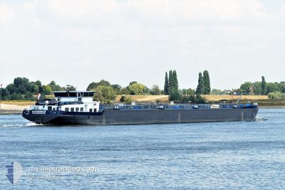
EVIDENCE
Tanker
Current Trip
NLAMS01005DOCKX00012
| Time Travelled | 4 days |
|---|---|
| Remaining Time | --- |
| Distance Travelled | 190.17 nm |
| Remaining Distance | --- |
| AVG Speed | 5 Knots |
| MAX Speed | 11 Knots |
| AVG Wind | 5.6 knots |
| MAX Wind | 9.8 knots |
| MIN Temp | 10.9°C / 51.62°F |
| MAX Temp | 26.1°C / 78.98°F |
| Draught | 2 m |
| Position Received | 3 d ago |
Current Position
| Longitude | 7.61475° |
|---|---|
| Latitude | 50.37607° |
| Status | Moored |
| Speed | |
| Course | --- |
| Area | North Sea |
| Station | T-AIS |
| Position Received | 3 d ago |
Info
Information
The current position of EVIDENCE is in North Sea with coordinates 50.37607° / 7.61475° as reported on 2024-05-13 22:57 by AIS to our vessel tracker app. The vessel's current speed is 0 Knots
The vessel EVIDENCE (MMSI: 244138927) is a Tanker It's sailing under the flag of [NL] Netherlands.
In this page you can find informations about the vessels current position, last detected port calls, and current voyage information. If the vessels is not in coverage by AIS you will find the latest position.
The current position of EVIDENCE is detected by our AIS receivers and we are not responsible for the reliability of the data. The last position was recorded while the vessel was in Coverage by the Ais receivers of our vessel tracking app.
The current draught of EVIDENCE as reported by AIS is 2 meters
Weather
| Temperature | 15.3°C / 59.54°F |
|---|---|
| Wind Speed | 3 knots |
| Direction | 279° W |
| Pressure | 1005.2 hPa |
| Humidity | 79.1 % |
| Cloud Coverage | 96 % |
Featured Company
Last Port Calls
| Port | Arrival | Departure | Time In Port |
|---|---|---|---|
| 2024-05-12 10:58 | 2024-05-12 13:14 | 2 h | |
| 2024-05-10 01:15 | 2024-05-12 08:15 | 2 d | |
| 2024-05-07 10:47 | 2024-05-09 06:14 | 1 d | |
| 2024-05-06 10:39 | 2024-05-06 12:37 | 1 h | |
| 2024-05-04 16:04 | 2024-05-06 07:40 | 1 d | |
| 2024-05-03 01:14 | 2024-05-03 12:46 | 11 h | |
| 2024-04-30 18:50 | 2024-05-02 06:19 | 1 d | |
| 2024-04-30 08:52 | 2024-04-30 18:33 | 9 h | |
| 2024-04-30 07:59 | 2024-04-30 08:16 | 16 m | |
| 2024-04-29 09:16 | 2024-04-29 10:06 | 49 m |
Most Visited Ports (Last year)
| Port | Arrivals | |
|---|---|---|
| 33 | ||
| 31 | ||
| 21 | ||
| 16 | ||
| 12 | ||
| 7 |
Last Trips
| Origin | Departure | Destination | Arrival | Distance | |
|---|---|---|---|---|---|
| 2024-05-12 10:15 | 2024-05-12 12:58 | 4.15 nm | |||
| 2024-05-09 08:14 | 2024-05-10 03:15 | 10.84 nm | |||
| 2024-05-06 14:37 | 2024-05-07 12:47 | 88.13 nm | |||
| 2024-05-06 09:40 | 2024-05-06 12:39 | 3.33 nm | |||
| 2024-05-03 14:46 | 2024-05-04 18:04 | 9.27 nm | |||
| 2024-05-02 08:19 | 2024-05-03 03:14 | 108.83 nm | |||
| 2024-04-30 20:33 | 2024-04-30 20:50 | 2.13 nm | |||
| 2024-04-30 10:16 | 2024-04-30 10:52 | 2.91 nm | |||
| 2024-04-29 12:06 | 2024-04-30 09:59 | 106.34 nm | |||
| 2024-04-29 07:58 | 2024-04-29 11:16 | 5.55 nm |
Events
| Time | Event | Details | Position / Dest | Info |
|---|---|---|---|---|
| 2024-05-16 13:49 | STOP Moving | 1.93 nm, South of TRIER |
49.72833 / 6.62167
NLAMS01005DOCKX00012
|
Speed: Course: -1° |
| 2024-05-15 11:33 | START Moving | 8.95 nm, East of TRIER |
49.79500 / 6.85333
NLAMS01005DOCKX00012
|
Speed: 8 kn Course: 190° |
| 2024-05-13 23:12 | Status Changed | Default Moored |
50.37667 / 7.61500
NLAMS01005DOCKX00012
|
Speed: Course: 511° |
| 2024-05-13 22:57 | OUT of Coverage |
50.37607 / 7.61475
North Sea
|
Speed: Course: 511° |
|
| 2024-05-13 22:51 | Status Changed | Moored Default |
50.37608 / 7.61470
NLAMS01005DOCKX00012
|
Speed: Course: -1° |
| 2024-05-13 22:39 | Status Changed | Default Moored |
50.37667 / 7.61500
NLAMS01005DOCKX00012
|
Speed: Course: 511° |
| 2024-05-13 22:03 | Status Changed | Moored Default |
50.37604 / 7.61474
NLAMS01005DOCKX00012
|
Speed: Course: -1° |
| 2024-05-13 22:03 | IN Coverage |
50.37604 / 7.61474
North Sea
|
Speed: Course: 511° |
|
| 2024-05-13 18:11 | STOP Moving | 1.35 nm, South East of RHEINHAFEN |
50.37667 / 7.61500
NLAMS01005DOCKX00012
|
Speed: Course: -1° |
| 2024-05-13 14:12 | OUT of Coverage |
50.49375 / 7.32230
North Sea
|
Speed: 5.3 kn Course: 135.6° |