
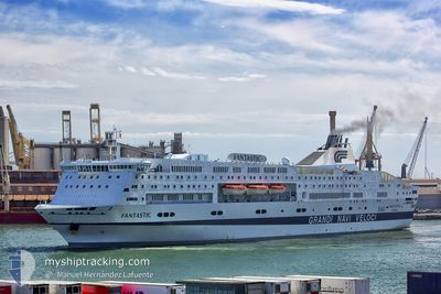
FANTASTIC
Ro-Ro/Passenger Ship
Current Trip
| Trip Time | 21 h, 31 mins |
|---|---|
| Trip Distance | 357.69 nm |
| AVG Speed | 14.7 Knots |
| MAX Speed | 18.4 Knots |
| Draught | 6.5 m |
| AVG Wind | 7.2 knots |
| MAX Wind | 16.8 knots |
| MIN Temp | 16.7°C / 62.06°F |
| MAX Temp | 19.3°C / 66.74°F |
| Position Received | Now |
Current Position
| Longitude | 8.91230° |
|---|---|
| Latitude | 44.40747° |
| Status | Moored |
| Speed | |
| Course | 104° |
| Area | Ligurian Sea |
| Station | T-AIS |
| Position Received | Now |
Info
Information
The current position of FANTASTIC is in Ligurian Sea with coordinates 44.40747° / 8.91230° as reported on 2024-05-19 05:22 by AIS to our vessel tracker app. The vessel's current speed is 0 Knots and is currently inside the port of GENOVA.
The vessel FANTASTIC (IMO: 9100267, MMSI: 247094000) is a Ro-Ro/Passenger Ship that was built in 1996 ( 28 years old ). It's sailing under the flag of [IT] Italy.
In this page you can find informations about the vessels current position, last detected port calls, and current voyage information. If the vessels is not in coverage by AIS you will find the latest position.
The current position of FANTASTIC is detected by our AIS receivers and we are not responsible for the reliability of the data. The last position was recorded while the vessel was in Coverage by the Ais receivers of our vessel tracking app.
The current draught of FANTASTIC as reported by AIS is 6.5 meters
Weather
| Temperature | 11.4°C / 52.52°F |
|---|---|
| Wind Speed | 4 knots |
| Direction | 26° NNE |
| Pressure | 1012.7 hPa |
| Humidity | 81.8 % |
| Cloud Coverage | 1 % |
Featured Company
Last Port Calls
| Port | Arrival | Departure | Time In Port |
|---|---|---|---|
| 2024-05-18 13:43 | |||
| 2024-05-17 04:12 | 2024-05-17 16:12 | 12 h | |
| 2024-05-15 13:18 | 2024-05-15 19:40 | 6 h | |
| 2024-05-13 10:13 | 2024-05-13 17:09 | 6 h | |
| 2024-05-12 21:14 | 2024-05-12 23:45 | 2 h | |
| 2024-05-11 10:45 | 2024-05-11 18:33 | 7 h | |
| 2024-05-10 03:01 | 2024-05-10 07:52 | 4 h | |
| 2024-05-09 09:52 | 2024-05-09 16:36 | 6 h | |
| 2024-05-07 08:36 | 2024-05-07 16:21 | 7 h | |
| 2024-05-05 05:41 | 2024-05-05 16:31 | 10 h |
Last Trips
| Origin | Departure | Destination | Arrival | Distance | |
|---|---|---|---|---|---|
| 2024-05-17 18:12 | 2024-05-18 15:43 | 357.69 nm | |||
| 2024-05-15 20:40 | 2024-05-17 06:12 | 538.04 nm | |||
| 2024-05-13 19:09 | 2024-05-15 14:18 | 681.11 nm | |||
| 2024-05-13 01:45 | 2024-05-13 12:13 | 156.00 nm | |||
| 2024-05-11 19:33 | 2024-05-12 23:14 | 442.36 nm | |||
| 2024-05-10 09:52 | 2024-05-11 11:45 | 441.87 nm | |||
| 2024-05-09 18:36 | 2024-05-10 05:01 | 155.98 nm | |||
| 2024-05-07 17:21 | 2024-05-09 11:52 | 684.90 nm | |||
| 2024-05-05 18:31 | 2024-05-07 09:36 | 683.57 nm | |||
| 2024-05-03 15:22 | 2024-05-05 07:41 | 594.00 nm |
Events
| Time | Event | Details | Position / Dest | Info |
|---|---|---|---|---|
| 2024-05-18 17:07 | Status Changed | Moored Under way using engine |
44.40680 / 8.91204
[IT] GENOVA
|
Speed: Course: 104° |
| 2024-05-18 14:10 | STOP Moving |
44.40682 / 8.91224
[IT] GENOVA
|
Speed: 0.3 kn Course: 103° |
|
| 2024-05-18 13:43 | PORT ARRIVAL |
|
44.38736 / 8.94669
[IT] GENOVA
|
Speed: 7.7 kn Course: 304.5° |
| 2024-05-18 09:04 | Change Sea Area | Italian part of the Ligurian Sea Italian part of the Mediterranean Sea - Western Basin |
43.66115 / 7.85901
Ligurian Sea
IT GOA
|
Speed: 15.1 kn Course: 49.9° |
| 2024-05-18 08:16 | Change Sea Area | Italian part of the Mediterranean Sea - Western Basin French part of the Mediterranean Sea - Western Basin |
43.52764 / 7.65257
Mediterranean Sea - Western Basin
IT GOA
|
Speed: 15 kn Course: 48.7° |
| 2024-05-18 07:58 | Change Sea Area | French part of the Mediterranean Sea - Western Basin Mon�gasque part of the Mediterranean Sea - Western Basin |
43.47797 / 7.57350
Mediterranean Sea - Western Basin
IT GOA
|
Speed: 15.4 kn Course: 49.5° |
| 2024-05-18 07:49 | Change Sea Area | Mon�gasque part of the Mediterranean Sea - Western Basin French part of the Mediterranean Sea - Western Basin |
43.45261 / 7.53247
Mediterranean Sea - Western Basin
IT GOA
|
Speed: 15.5 kn Course: 50.1° |
| 2024-05-18 04:29 | Status Changed | Under way using engine Default |
42.89752 / 6.52418
IT GOA
|
Speed: 16.9 kn Course: 63° |
| 2024-05-18 04:16 | IN Coverage |
42.89752 / 6.52418
Mediterranean Sea - Western Basin
IT GOA
|
Speed: 16.7 kn Course: 66.4° |
|
| 2024-05-18 02:49 | OUT of Coverage |
42.69061 / 5.95331
Mediterranean Sea - Western Basin
IT GOA
|
Speed: 17 kn Course: 63.2° |