
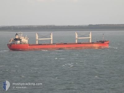
FEDERAL CARIBOU
Cargo
Current Trip
| Time Travelled | 32 days |
|---|---|
| Remaining Time | 21 h, 32 mins |
| Distance Travelled | 5632.06 nm |
| Remaining Distance | 233.31 nm |
| AVG Speed | 10.8 Knots |
| MAX Speed | 18.2 Knots |
| AVG Wind | 8.1 knots |
| MAX Wind | 21.9 knots |
| MIN Temp | 6.4°C / 43.52°F |
| MAX Temp | 33.2°C / 91.76°F |
| Draught | 6.3 m |
| Position Received | 1 d ago |
Current Position
| Longitude | -38.60314° |
|---|---|
| Latitude | -13.03881° |
| Status | At anchor |
| Speed | 0.2 Knots |
| Course | 141° |
| Area | South Atlantic Ocean |
| Station | T-AIS |
| Position Received | 1 d ago |
Info
Information
The current position of FEDERAL CARIBOU is in South Atlantic Ocean with coordinates -13.03881° / -38.60314° as reported on 2024-06-07 13:17 by AIS to our vessel tracker app. The vessel's current speed is 0.2 Knots and is heading at the port of SALVADOR. The estimated time of arrival as calculated by vessel tracking app is 2024-06-09 22:31 LT
The vessel FEDERAL CARIBOU (IMO: 9671096, MMSI: 538006472) is a Cargo It's sailing under the flag of [MH] Marshall Is.
In this page you can find informations about the vessels current position, last detected port calls, and current voyage information. If the vessels is not in coverage by AIS you will find the latest position.
The current position of FEDERAL CARIBOU is detected by our AIS receivers and we are not responsible for the reliability of the data. The last position was recorded while the vessel was in Coverage by the Ais receivers of our vessel tracking app.
The current draught of FEDERAL CARIBOU as reported by AIS is 6.3 meters
Weather
| Temperature | 26°C / 78.8°F |
|---|---|
| Wind Speed | 17 knots |
| Direction | 139° SE |
| Pressure | 1020.5 hPa |
| Humidity | 76.5 % |
| Cloud Coverage | 15 % |
Featured Company
Last Port Calls
| Port | Arrival | Departure | Time In Port |
|---|---|---|---|
| 2024-05-06 00:57 | 2024-05-07 01:58 | 1 d | |
| 2024-04-24 04:52 | 2024-04-24 06:58 | 2 h | |
| 2024-04-22 20:37 | 2024-04-22 21:12 | 35 m | |
| 2024-04-21 14:08 | 2024-04-21 18:16 | 4 h | |
| 2024-04-20 12:41 | 2024-04-20 13:37 | 56 m | |
| 2024-04-15 18:09 | 2024-04-19 12:02 | 3 d | |
| 2024-04-05 21:51 | 2024-04-10 12:55 | 4 d | |
| 2024-04-01 01:22 | 2024-04-01 02:05 | 43 m |
Most Visited Ports (Last year)
| Port | Arrivals | |
|---|---|---|
| 8 | ||
| 6 | ||
| 6 | ||
| 3 | ||
| 3 | ||
| 2 |
Last Trips
| Origin | Departure | Destination | Arrival | Distance | |
|---|---|---|---|---|---|
| 2024-04-24 02:58 | 2024-05-05 21:57 | 1265.54 nm | |||
| 2024-04-22 17:12 | 2024-04-24 00:52 | 296.75 nm | |||
| 2024-04-21 14:16 | 2024-04-22 16:37 | 229.50 nm | |||
| 2024-04-20 09:37 | 2024-04-21 10:08 | 283.56 nm | |||
| 2024-04-19 08:02 | 2024-04-20 08:41 | 211.93 nm | |||
| 2024-04-10 08:55 | 2024-04-15 14:09 | 244.41 nm | |||
| 2024-03-31 22:05 | 2024-04-05 17:51 | 573.84 nm | |||
| 2024-03-30 10:42 | 2024-03-31 21:22 | 297.10 nm |
Events
| Time | Event | Details | Position / Dest | Info |
|---|---|---|---|---|
| 2024-06-08 03:06 | START Moving | 2.56 nm, North West of SALVADOR |
-12.93900 / -38.54661
BR_SSA
|
Speed: 5.3 kn Course: 192° |
| 2024-06-07 19:58 | STOP Moving | 2.83 nm, North West of SALVADOR |
-12.93213 / -38.54605
BR_SSA
|
Speed: 0.3 kn Course: 156° |
| 2024-06-07 18:30 | START Moving | 6.49 nm, South West of SALVADOR |
-13.04042 / -38.59645
BR_SSA
|
Speed: 3.6 kn Course: 110° |
| 2024-06-07 13:20 | Status Changed | Default At anchor |
-13.03898 / -38.60329
BR_SSA
|
Speed: 0.2 kn Course: 141° |
| 2024-06-07 13:17 | OUT of Coverage |
-13.03881 / -38.60314
South Atlantic Ocean
|
Speed: 0.2 kn Course: 330° |
|
| 2024-06-07 13:08 | Change Sea Area | Brazilian part of the South Atlantic Ocean Brazilian part of the North Atlantic Ocean |
-13.03930 / -38.60364
South Atlantic Ocean
|
Speed: 0.3 kn Course: 104.3° |
| 2024-06-07 13:08 | Status Changed | At anchor Default |
-13.03930 / -38.60364
BR_SSA
|
Speed: 0.4 kn Course: 131° |
| 2024-06-07 12:50 | IN Coverage |
-13.03930 / -38.60364
South Atlantic Ocean
|
Speed: 0.3 kn Course: 104.3° |
|
| 2024-06-04 20:14 | STOP Moving | 6.87 nm, South West of SALVADOR |
-13.04167 / -38.60402
BR_SSA
|
Speed: 0.3 kn Course: 58° |