
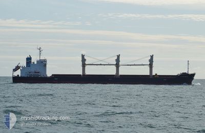
FERASET
Cargo
Current Trip
| Time Travelled | 4 days |
|---|---|
| Remaining Time | --- |
| Distance Travelled | 627.69 nm |
| Remaining Distance | --- |
| AVG Speed | 12 Knots |
| MAX Speed | 13.3 Knots |
| AVG Wind | 7.3 knots |
| MAX Wind | 16.9 knots |
| MIN Temp | 17°C / 62.6°F |
| MAX Temp | 23.6°C / 74.48°F |
| Draught | 5.7 m |
| Position Received | Now |
Current Position
| Longitude | 24.67245° |
|---|---|
| Latitude | 37.98943° |
| Status | Under way using engine |
| Speed | 11.8 Knots |
| Course | 26.8° |
| Area | Aegean Sea |
| Station | T-AIS |
| Position Received | Now |
Info
Information
The current position of FERASET is in Aegean Sea with coordinates 37.98943° / 24.67245° as reported on 2024-05-29 10:32 by AIS to our vessel tracker app. The vessel's current speed is 11.8 Knots and is heading at the port of CONSTANTA. The estimated time of arrival as calculated by vessel tracking app is 2024-05-31 05:00 LT
The vessel FERASET (IMO: 9747651, MMSI: 256621000) is a Cargo It's sailing under the flag of [MT] Malta.
In this page you can find informations about the vessels current position, last detected port calls, and current voyage information. If the vessels is not in coverage by AIS you will find the latest position.
The current position of FERASET is detected by our AIS receivers and we are not responsible for the reliability of the data. The last position was recorded while the vessel was in Coverage by the Ais receivers of our vessel tracking app.
The current draught of FERASET as reported by AIS is 5.7 meters
Weather
| Temperature | 20.7°C / 69.26°F |
|---|---|
| Wind Speed | 6 knots |
| Direction | 48° NE |
| Pressure | 1013 hPa |
| Humidity | 61.5 % |
| Cloud Coverage | 5 % |
Featured Company
Last Port Calls
| Port | Arrival | Departure | Time In Port |
|---|---|---|---|
| 2024-05-17 08:18 | 2024-05-24 13:16 | 7 d | |
| 2024-04-10 14:34 | 2024-04-21 02:11 | 10 d | |
| 2024-04-04 01:35 | 2024-04-05 19:05 | 1 d | |
| 2024-03-25 19:48 | 2024-03-27 13:36 | 1 d | |
| 2024-03-09 00:20 | 2024-03-15 16:24 | 6 d | |
| 2024-03-03 18:58 | 2024-03-07 20:27 | 4 d |
Most Visited Ports (Last year)
| Port | Arrivals | |
|---|---|---|
| 3 | ||
| 2 | ||
| 2 | ||
| 2 | ||
| 1 | ||
| 1 |
Last Trips
| Origin | Departure | Destination | Arrival | Distance | |
|---|---|---|---|---|---|
| 2024-04-20 23:11 | 2024-05-17 10:18 | 6177.96 nm | |||
| 2024-04-05 16:05 | 2024-04-10 11:34 | 1046.68 nm | |||
| 2024-03-27 10:36 | 2024-04-03 22:35 | 817.06 nm | |||
| 2024-03-15 13:24 | 2024-03-25 16:48 | 461.57 nm | |||
| 2024-03-07 17:27 | 2024-03-08 21:20 | 161.57 nm | |||
| 2024-02-25 08:38 | 2024-03-03 15:58 | 963.12 nm |
Events
| Time | Event | Details | Position / Dest | Info |
|---|---|---|---|---|
| 2024-05-29 09:06 | ETA Changed | 2024/05/31 05:00 2024/05/31 11:00 |
37.72925 / 24.51915
ROCND
|
Speed: 12.4 kn Course: 24.6° |
| 2024-05-29 08:44 | Destination Changed | ROCND TRIST |
37.65853 / 24.47892
ROCND
|
Speed: 12.3 kn Course: 24.9° |
| 2024-05-29 08:37 | ETA Changed | 2024/05/31 11:00 2024/05/30 10:00 |
37.63795 / 24.46723
TRIST
|
Speed: 12 kn Course: 24.7° |
| 2024-05-29 01:37 | Status Changed | Under way using engine Default |
36.52339 / 23.40216
TRIST
|
Speed: 12 kn Course: 39° |
| 2024-05-29 01:31 | Status Changed | Default Under way using engine |
36.50500 / 23.38333
TRIST
|
Speed: 12.3 kn Course: 38.7° |
| 2024-05-29 01:25 | Status Changed | Under way using engine Default |
36.49054 / 23.36941
TRIST
|
Speed: 12 kn Course: 40° |
| 2024-05-29 00:56 | Status Changed | Default Under way using engine |
36.41548 / 23.29054
TRIST
|
Speed: 11.9 kn Course: 56.5° |
| 2024-05-29 00:48 | Status Changed | Under way using engine Default |
36.39784 / 23.26396
TRIST
|
Speed: 12.4 kn Course: 75° |
| 2024-05-29 00:17 | Status Changed | Default Under way using engine |
36.38472 / 23.13777
TRIST
|
Speed: 12.4 kn Course: 91° |
| 2024-05-29 00:12 | Change Sea Area | Greek part of the Aegean Sea Greek part of the Ionian Sea |
36.38492 / 23.11485
Aegean Sea
TRIST
|
Speed: 12.4 kn Course: 91° |