
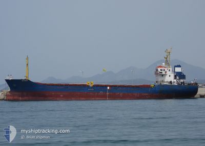
FG SEFA
General Cargo
Current Trip
| Time Travelled | 1 day |
|---|---|
| Remaining Time | --- |
| Distance Travelled | 220.60 nm |
| Remaining Distance | --- |
| AVG Speed | 8 Knots |
| MAX Speed | 11.6 Knots |
| AVG Wind | 5.5 knots |
| MAX Wind | 20 knots |
| MIN Temp | 13.2°C / 55.76°F |
| MAX Temp | 19.3°C / 66.74°F |
| Draught | 5 m |
| Position Received | 5 m ago |
Current Position
| Longitude | 29.17357° |
|---|---|
| Latitude | 40.88177° |
| Status | At anchor |
| Speed | |
| Course | 145° |
| Area | Sea of Marmara |
| Station | T-AIS |
| Position Received | 5 m ago |
Info
Information
The current position of FG SEFA is in Sea of Marmara with coordinates 40.88177° / 29.17357° as reported on 2024-05-29 04:12 by AIS to our vessel tracker app. The vessel's current speed is 0 Knots and is heading at the port of POZZALLO. The estimated time of arrival as calculated by vessel tracking app is 2024-06-03 19:00 LT
The vessel FG SEFA (IMO: 9359210, MMSI: 352001626) is a General Cargo that was built in 2005 ( 19 years old ). It's sailing under the flag of [PA] Panama.
In this page you can find informations about the vessels current position, last detected port calls, and current voyage information. If the vessels is not in coverage by AIS you will find the latest position.
The current position of FG SEFA is detected by our AIS receivers and we are not responsible for the reliability of the data. The last position was recorded while the vessel was in Coverage by the Ais receivers of our vessel tracking app.
The current draught of FG SEFA as reported by AIS is 5 meters
Weather
| Temperature | 14.9°C / 58.82°F |
|---|---|
| Wind Speed | 2 knots |
| Direction | 140° SE |
| Pressure | 1013.8 hPa |
| Humidity | 81.1 % |
| Cloud Coverage | --- |
Featured Company
Last Port Calls
| Port | Arrival | Departure | Time In Port |
|---|---|---|---|
| 2024-05-25 19:56 | 2024-05-27 08:44 | 1 d | |
| 2024-05-17 04:48 | 2024-05-21 16:44 | 4 d | |
| 2024-05-11 11:11 | 2024-05-13 08:11 | 1 d | |
| 2024-05-07 14:16 | 2024-05-09 19:04 | 2 d | |
| 2024-04-23 12:04 | 2024-04-27 09:00 | 3 d | |
| 2024-04-17 04:40 | 2024-04-19 14:09 | 2 d | |
| 2024-04-01 17:36 | 2024-04-04 04:05 | 2 d | |
| 2024-03-13 17:28 | 2024-03-14 11:52 | 18 h | |
| 2024-03-03 16:07 | 2024-03-08 07:45 | 4 d |
Last Trips
| Origin | Departure | Destination | Arrival | Distance | |
|---|---|---|---|---|---|
| 2024-05-21 19:44 | 2024-05-25 22:56 | 600.47 nm | |||
| 2024-05-13 10:11 | 2024-05-17 07:48 | 681.23 nm | |||
| 2024-05-09 22:04 | 2024-05-11 13:11 | 293.40 nm | |||
| 2024-04-27 12:00 | 2024-05-07 17:16 | 952.71 nm | |||
| 2024-04-19 17:09 | 2024-04-23 15:04 | 273.49 nm | |||
| 2024-04-04 07:05 | 2024-04-17 07:40 | 450.46 nm | |||
| 2024-03-14 14:52 | 2024-04-01 20:36 | 602.01 nm | |||
| 2024-03-08 09:45 | 2024-03-13 20:28 | 586.58 nm | |||
| 2024-02-22 18:56 | 2024-03-03 18:07 | 484.19 nm |
Events
| Time | Event | Details | Position / Dest | Info |
|---|---|---|---|---|
| 2024-05-29 02:30 | Status Changed | At anchor Default |
40.88172 / 29.17346
ITPZL
|
Speed: Course: 172° |
| 2024-05-29 02:24 | Status Changed | Default At anchor |
40.88171 / 29.17341
ITPZL
|
Speed: Course: 174° |
| 2024-05-29 01:33 | Status Changed | At anchor Under way using engine |
40.88127 / 29.17349
ITPZL
|
Speed: 0.7 kn Course: 119° |
| 2024-05-29 01:28 | STOP Moving | 1.37 nm, West of KARTAL |
40.88091 / 29.17363
ITPZL
|
Speed: 0.3 kn Course: 116° |
| 2024-05-28 22:33 | START Moving | 0.71 nm, South of BAKIRKOY |
40.96176 / 28.88203
ITPZL
|
Speed: 4.2 kn Course: 127° |
| 2024-05-28 22:19 | Status Changed | Under way using engine At anchor |
40.96296 / 28.87842
ITPZL
|
Speed: 0.2 kn Course: 74° |
| 2024-05-28 09:48 | Status Changed | At anchor Under way using engine |
40.96366 / 28.88056
ITPZL
|
Speed: 0.7 kn Course: 255° |
| 2024-05-28 09:41 | STOP Moving | 0.6 nm, South of BAKIRKOY |
40.96336 / 28.87974
ITPZL
|
Speed: 0.3 kn Course: 235° |
| 2024-05-28 07:08 | Change Sea Area | Turkish part of the Sea of Marmara Turkish part of the Black Sea |
41.23189 / 29.13278
Sea of Marmara
ITPZL
|
Speed: 8.5 kn Course: 207° |
| 2024-05-28 04:00 | Change Sea Area | Turkish part of the Black Sea Romanian part of the Black Sea |
41.46837 / 29.02941
Black Sea
ITPZL
|
Speed: 7.9 kn Course: 172.6° |