
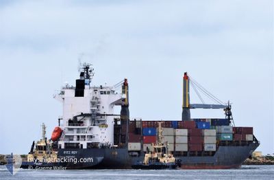
FITZ ROY
Container Ship
Current Trip
| Time Travelled | 5 days |
|---|---|
| Remaining Time | --- |
| Distance Travelled | 1473.74 nm |
| Remaining Distance | --- |
| AVG Speed | 11.6 Knots |
| MAX Speed | 17.9 Knots |
| AVG Wind | 10.1 knots |
| MAX Wind | 19.5 knots |
| MIN Temp | 25.6°C / 78.08°F |
| MAX Temp | 30.1°C / 86.18°F |
| Draught | 9.2 m |
| Position Received | 1 d ago |
Current Position
| Longitude | 98.99237° |
|---|---|
| Latitude | 5.70230° |
| Status | Under way using engine |
| Speed | 11.7 Knots |
| Course | 147.9° |
| Area | Malacca Strait |
| Station | T-AIS |
| Position Received | 1 d ago |
Info
Information
The current position of FITZ ROY is in Malacca Strait with coordinates 5.70230° / 98.99237° as reported on 2024-06-25 17:55 by AIS to our vessel tracker app. The vessel's current speed is 11.7 Knots
The vessel FITZ ROY (IMO: 9516739, MMSI: 636018769) is a Container Ship that was built in 2011 ( 13 years old ). It's sailing under the flag of [LR] Liberia.
In this page you can find informations about the vessels current position, last detected port calls, and current voyage information. If the vessels is not in coverage by AIS you will find the latest position.
The current position of FITZ ROY is detected by our AIS receivers and we are not responsible for the reliability of the data. The last position was recorded while the vessel was in Coverage by the Ais receivers of our vessel tracking app.
The current draught of FITZ ROY as reported by AIS is 9.2 meters
Weather
| Temperature | 29.8°C / 85.64°F |
|---|---|
| Wind Speed | 9 knots |
| Direction | 137° SE |
| Pressure | 1007.4 hPa |
| Humidity | 69.7 % |
| Cloud Coverage | 100 % |
Featured Company
Last Port Calls
| Port | Arrival | Departure | Time In Port |
|---|---|---|---|
| 2024-06-19 02:20 | 2024-06-22 04:54 | 3 d | |
| 2024-06-10 07:35 | 2024-06-11 12:16 | 1 d | |
| 2024-06-01 00:00 | 2024-06-04 01:32 | 3 d | |
| 2024-05-25 01:08 | 2024-05-26 03:33 | 1 d | |
| 2024-05-17 10:48 | 2024-05-20 02:12 | 2 d | |
| 2024-05-08 07:41 | 2024-05-09 06:22 | 22 h | |
| 2024-04-28 07:41 | 2024-05-01 10:52 | 3 d | |
| 2024-04-22 11:24 | 2024-04-23 11:31 | 1 d | |
| 2024-04-14 06:42 | 2024-04-16 23:55 | 2 d | |
| 2024-04-08 00:53 | 2024-04-08 21:51 | 20 h |
Most Visited Ports (Last year)
| Port | Arrivals | |
|---|---|---|
| 19 | ||
| 11 | ||
| 8 | ||
| 1 |
Last Trips
| Origin | Departure | Destination | Arrival | Distance | |
|---|---|---|---|---|---|
| 2024-06-11 20:16 | 2024-06-19 08:20 | 1560.47 nm | |||
| 2024-06-04 07:32 | 2024-06-10 15:35 | 1513.17 nm | |||
| 2024-05-26 11:33 | 2024-06-01 06:00 | 1521.45 nm | |||
| 2024-05-20 08:12 | 2024-05-25 09:08 | 1518.41 nm | |||
| 2024-05-09 14:22 | 2024-05-17 16:48 | 1556.27 nm | |||
| 2024-05-01 16:52 | 2024-05-08 15:41 | 1543.47 nm | |||
| 2024-04-23 19:31 | 2024-04-28 13:41 | 1504.30 nm | |||
| 2024-04-17 05:55 | 2024-04-22 19:24 | 1503.31 nm | |||
| 2024-04-09 05:51 | 2024-04-14 12:42 | 1531.49 nm | |||
| 2024-04-03 16:37 | 2024-04-08 08:53 | 1508.79 nm |
Events
| Time | Event | Details | Position / Dest | Info |
|---|---|---|---|---|
| 2024-06-25 18:01 | Status Changed | Default Under way using engine |
5.68667 / 99.00225
SGSIN PWBGA
|
Speed: 11.7 kn Course: 147.9° |
| 2024-06-25 17:55 | OUT of Coverage |
5.70230 / 98.99237
Malacca Strait
SGSIN PWBGA
|
Speed: 11.7 kn Course: 147.9° |
|
| 2024-06-25 17:53 | Status Changed | Under way using engine Default |
5.70832 / 98.98856
SGSIN PWBGA
|
Speed: 11.6 kn Course: 148° |
| 2024-06-25 17:50 | Status Changed | Default Under way using engine |
5.71743 / 98.98277
SGSIN PWBGA
|
Speed: 11.6 kn Course: 147.7° |
| 2024-06-25 17:40 | Change Sea Area | Malaysian part of the Malacca Strait Bangladeshi part of the Bay of Bengal |
5.74349 / 98.96625
Malacca Strait
SGSIN PWBGA
|
Speed: 11.6 kn Course: 148.1° |
| 2024-06-25 17:40 | Status Changed | Under way using engine Default |
5.74349 / 98.96625
SGSIN PWBGA
|
Speed: 11.5 kn Course: 148° |
| 2024-06-25 17:34 | IN Coverage |
5.74349 / 98.96625
Malacca Strait
SGSIN PWBGA
|
Speed: 11.6 kn Course: 148.1° |
|
| 2024-06-22 06:45 | Status Changed | Default Under way using engine |
22.10771 / 91.74829
SGSIN PWBGA
|
Speed: 10.2 kn Course: 192.5° |
| 2024-06-22 06:40 | OUT of Coverage |
22.12236 / 91.75243
Bay of Bengal
SGSIN PWBGA
|
Speed: 10.2 kn Course: 192.5° |
|
| 2024-06-22 06:09 | START Moving | 3.36 nm, South West of CHITTAGONG |
22.19904 / 91.76998
SGSIN PWBGA
|
Speed: 3.5 kn Course: 182° |