
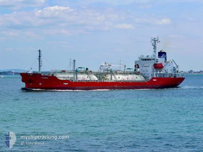
FORBIN
Lpg Tanker
Current Trip
| Time Travelled | 1 day |
|---|---|
| Remaining Time | --- |
| Distance Travelled | 484.72 nm |
| Remaining Distance | 61.84 nm |
| AVG Speed | 11 Knots |
| MAX Speed | 13.4 Knots |
| AVG Wind | 17.2 knots |
| MAX Wind | 29 knots |
| MIN Temp | 9.8°C / 49.64°F |
| MAX Temp | 14.6°C / 58.28°F |
| Draught | 6.5 m |
| Position Received | 2 m ago |
Current Position
| Longitude | 3.35145° |
|---|---|
| Latitude | 51.81693° |
| Status | At anchor |
| Speed | 0.3 Knots |
| Course | 211° |
| Area | North Sea |
| Station | T-AIS |
| Position Received | 2 m ago |
Info
Information
The current position of FORBIN is in North Sea with coordinates 51.81693° / 3.35145° as reported on 2024-06-15 13:26 by AIS to our vessel tracker app. The vessel's current speed is 0.3 Knots and is heading at the port of ANTWERP. The estimated time of arrival as calculated by vessel tracking app is 2024-06-15 10:00 LT
The vessel FORBIN (IMO: 9559652, MMSI: 248976000) is a Lpg Tanker that was built in 2011 ( 13 years old ). It's sailing under the flag of [MT] Malta.
In this page you can find informations about the vessels current position, last detected port calls, and current voyage information. If the vessels is not in coverage by AIS you will find the latest position.
The current position of FORBIN is detected by our AIS receivers and we are not responsible for the reliability of the data. The last position was recorded while the vessel was in Coverage by the Ais receivers of our vessel tracking app.
The current draught of FORBIN as reported by AIS is 6.5 meters
Weather
| Temperature | 14.6°C / 58.28°F |
|---|---|
| Wind Speed | 29 knots |
| Direction | 216° SW |
| Pressure | 1002.1 hPa |
| Humidity | 80.6 % |
| Cloud Coverage | 98 % |
Featured Company
Last Port Calls
| Port | Arrival | Departure | Time In Port |
|---|---|---|---|
| 2024-06-12 19:44 | 2024-06-13 16:30 | 20 h | |
| 2024-06-09 04:45 | 2024-06-10 12:52 | 1 d | |
| 2024-05-30 23:14 | 2024-05-31 22:38 | 23 h | |
| 2024-05-24 22:51 | 2024-05-29 20:03 | 4 d | |
| 2024-05-18 17:51 | 2024-05-20 19:48 | 2 d | |
| 2024-05-15 05:29 | 2024-05-16 04:22 | 22 h | |
| 2024-05-11 08:02 | 2024-05-13 10:36 | 2 d | |
| 2024-05-04 16:09 | 2024-05-05 04:19 | 12 h | |
| 2024-04-20 20:17 | 2024-04-22 06:29 | 1 d | |
| 2024-04-17 20:48 | 2024-04-18 15:16 | 18 h |
Last Trips
| Origin | Departure | Destination | Arrival | Distance | |
|---|---|---|---|---|---|
| 2024-06-10 14:52 | 2024-06-12 21:44 | 548.21 nm | |||
| 2024-06-01 00:38 | 2024-06-09 06:45 | 660.79 nm | |||
| 2024-05-29 22:03 | 2024-05-31 01:14 | 39.05 nm | |||
| 2024-05-20 21:48 | 2024-05-25 00:51 | 689.68 nm | |||
| 2024-05-16 06:22 | 2024-05-18 19:51 | 550.02 nm | |||
| 2024-05-13 12:36 | 2024-05-15 07:29 | 547.15 nm | |||
| 2024-05-05 06:19 | 2024-05-11 10:02 | 562.88 nm | |||
| 2024-04-22 08:29 | 2024-05-04 18:09 | 675.86 nm | |||
| 2024-04-18 16:16 | 2024-04-20 22:17 | 320.82 nm | |||
| 2024-04-16 18:42 | 2024-04-17 21:48 | 308.65 nm |
Events
| Time | Event | Details | Position / Dest | Info |
|---|---|---|---|---|
| 2024-06-15 10:59 | Status Changed | At anchor Default |
51.81657 / 3.35081
BEANR VIA STEENBANK
|
Speed: 0.2 kn Course: 209° |
| 2024-06-15 10:53 | Status Changed | Default At anchor |
51.81661 / 3.35079
BEANR VIA STEENBANK
|
Speed: 0.2 kn Course: 209° |
| 2024-06-15 10:32 | STOP Moving | 17.31 nm, North West of NEELTJE JANS |
51.81630 / 3.35104
BEANR VIA STEENBANK
|
Speed: 0.3 kn Course: 225° |
| 2024-06-15 10:25 | Status Changed | At anchor Under way using engine |
51.81559 / 3.34767
BEANR VIA STEENBANK
|
Speed: 2.1 kn Course: 174° |
| 2024-06-15 10:24 | Status Changed | Under way using engine At anchor |
51.81529 / 3.34690
BEANR VIA STEENBANK
|
Speed: 1.1 kn Course: 191° |
| 2024-06-15 10:23 | Status Changed | At anchor Under way using engine |
51.81558 / 3.34757
BEANR VIA STEENBANK
|
Speed: 1.8 kn Course: 180° |
| 2024-06-15 07:31 | Change Sea Area | Dutch part of the North Sea United Kingdom part of the North Sea |
52.00240 / 2.64492
North Sea
BEANR VIA STEENBANK
|
Speed: 11.5 kn Course: 127.1° |
| 2024-06-15 06:58 | Status Changed | Under way using engine Default |
52.09690 / 2.63950
BEANR VIA STEENBANK
|
Speed: 10.9 kn Course: 181° |
| 2024-06-15 06:55 | Status Changed | Default Under way using engine |
52.10645 / 2.63992
BEANR VIA STEENBANK
|
Speed: 11 kn Course: 180° |
| 2024-06-15 06:44 | Detected in Sea | United Kingdom part of the North Sea |
52.13989 / 2.64076
North Sea
BEANR VIA STEENBANK
|
Speed: 11.1 kn Course: 179.5° |