
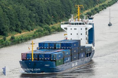
FREJ
General Cargo
Current Trip
| Time Travelled | 1 day |
|---|---|
| Remaining Time | 1 day |
| Distance Travelled | 497.06 nm |
| Remaining Distance | 447.82 nm |
| AVG Speed | 13 Knots |
| MAX Speed | 14.3 Knots |
| AVG Wind | 6 knots |
| MAX Wind | 14.1 knots |
| MIN Temp | 11.6°C / 52.88°F |
| MAX Temp | 16.3°C / 61.34°F |
| Draught | 5.9 m |
| Position Received | 1 m ago |
Current Position
| Longitude | 10.14416° |
|---|---|
| Latitude | 57.80256° |
| Status | Under way using engine |
| Speed | 12.7 Knots |
| Course | 236.7° |
| Area | Skaggerak |
| Station | T-AIS |
| Position Received | 1 m ago |
Info
Information
The current position of FREJ is in Skaggerak with coordinates 57.80256° / 10.14416° as reported on 2024-05-28 05:58 by AIS to our vessel tracker app. The vessel's current speed is 12.7 Knots and is heading at the port of HULL. The estimated time of arrival as calculated by vessel tracking app is 2024-05-29 17:04 LT
The vessel FREJ (IMO: 9101156, MMSI: 304010515) is a General Cargo that was built in 1994 ( 30 years old ). It's sailing under the flag of [AG] Antigua Barbuda.
In this page you can find informations about the vessels current position, last detected port calls, and current voyage information. If the vessels is not in coverage by AIS you will find the latest position.
The current position of FREJ is detected by our AIS receivers and we are not responsible for the reliability of the data. The last position was recorded while the vessel was in Coverage by the Ais receivers of our vessel tracking app.
The current draught of FREJ as reported by AIS is 5.9 meters
Weather
| Temperature | 14.1°C / 57.38°F |
|---|---|
| Wind Speed | 5 knots |
| Direction | 357° N |
| Pressure | 1015.2 hPa |
| Humidity | 87 % |
| Cloud Coverage | 87 % |
Featured Company
Last Port Calls
| Port | Arrival | Departure | Time In Port |
|---|---|---|---|
| 2024-05-24 15:26 | 2024-05-26 15:45 | 2 d | |
| 2024-05-24 06:56 | 2024-05-24 11:12 | 4 h | |
| 2024-05-21 07:35 | 2024-05-21 12:27 | 4 h | |
| 2024-05-19 12:10 | 2024-05-20 14:28 | 1 d | |
| 2024-05-17 20:34 | 2024-05-17 21:10 | 35 m | |
| 2024-05-15 23:13 | 2024-05-16 11:42 | 12 h | |
| 2024-05-15 18:10 | 2024-05-15 18:56 | 46 m | |
| 2024-05-13 21:58 | 2024-05-15 13:38 | 1 d | |
| 2024-05-13 10:51 | 2024-05-13 17:53 | 7 h | |
| 2024-05-12 00:30 | 2024-05-12 00:33 | 2 m |
Last Trips
| Origin | Departure | Destination | Arrival | Distance | |
|---|---|---|---|---|---|
| 2024-05-24 13:12 | 2024-05-24 17:26 | 52.64 nm | |||
| 2024-05-21 14:27 | 2024-05-24 08:56 | 730.86 nm | |||
| 2024-05-20 15:28 | 2024-05-21 09:35 | 207.89 nm | |||
| 2024-05-17 23:10 | 2024-05-19 13:10 | 403.47 nm | |||
| 2024-05-16 13:42 | 2024-05-17 22:34 | 416.77 nm | |||
| 2024-05-15 20:56 | 2024-05-16 01:13 | 52.34 nm | |||
| 2024-05-15 15:38 | 2024-05-15 20:10 | 48.79 nm | |||
| 2024-05-13 19:53 | 2024-05-13 23:58 | 48.98 nm | |||
| 2024-05-12 02:33 | 2024-05-13 12:51 | 444.88 nm | |||
| 2024-05-10 22:42 | 2024-05-12 02:30 | 288.16 nm |
Events
| Time | Event | Details | Position / Dest | Info |
|---|---|---|---|---|
| 2024-05-28 03:53 | Change Sea Area | Danish part of the Skaggerak Danish part of the Kattegat |
57.79948 / 10.92358
Skaggerak
GBHUL VIA SKAW
|
Speed: 12.9 kn Course: 312° |
| 2024-05-28 02:44 | Detected in Sea | Danish part of the Kattegat |
57.61400 / 11.23730
Kattegat
GBHUL VIA SKAW
|
Speed: 13.3 kn Course: 317.8° |
| 2024-05-27 19:08 | Change Sea Area | Swedish part of the Kattegat Danish part of the Kattegat |
56.14144 / 12.50177
Kattegat
GBHUL VIA SKAW
|
Speed: 14 kn Course: 315.9° |
| 2024-05-27 18:53 | Change Sea Area | Danish part of the Kattegat Swedish part of the Kattegat |
56.09983 / 12.57454
Kattegat
GBHUL VIA SKAW
|
Speed: 14 kn Course: 314° |
| 2024-05-27 17:31 | Change Sea Area | Swedish part of the Kattegat Danish part of the Kattegat |
55.82743 / 12.72335
Kattegat
GBHUL VIA SKAW
|
Speed: 13.6 kn Course: 12° |
| 2024-05-27 15:52 | Change Sea Area | Danish part of the Kattegat Swedish part of the Kattegat |
55.48823 / 12.70924
Kattegat
GBHUL VIA SKAW
|
Speed: 12.8 kn Course: 357.9° |
| 2024-05-27 15:10 | Change Sea Area | Swedish part of the Kattegat Swedish part of the Baltic Sea |
55.33715 / 12.67595
Kattegat
GBHUL VIA SKAW
|
Speed: 13.2 kn Course: 5° |
| 2024-05-27 11:45 | Draught Changed | 5.9 5.8 |
55.23716 / 13.94560
GBHUL VIA SKAW
|
Speed: 13.6 kn Course: 271.6° |
| 2024-05-27 08:58 | Change Sea Area | Swedish part of the Baltic Sea Danish part of the Kattegat |
55.52743 / 14.78636
Baltic Sea
GBHUL VIA SKAW
|
Speed: 13 kn Course: 235.9° |
| 2024-05-27 07:52 | Detected in Sea | Danish part of the Kattegat |
55.66721 / 15.13392
Kattegat
GBHUL VIA SKAW
|
Speed: 13.2 kn Course: 235.8° |