
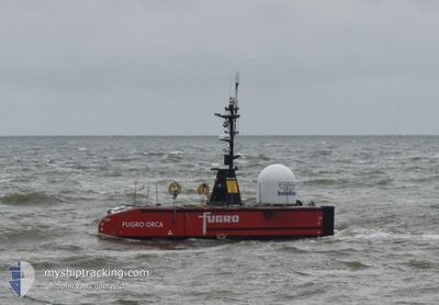
FUGRO ORCA
Other Type
Current Trip
SURVEY SITE
| Time Travelled | 9 days |
|---|---|
| Remaining Time | --- |
| Distance Travelled | 147.01 nm |
| Remaining Distance | --- |
| AVG Speed | 4.4 Knots |
| MAX Speed | 6.6 Knots |
| AVG Wind | 8.9 knots |
| MAX Wind | 12.8 knots |
| MIN Temp | 14°C / 57.2°F |
| MAX Temp | 18.9°C / 66.02°F |
| Draught | 2.5 m |
| Position Received | 1 h, 54 m ago |
Current Position
| Longitude | 2.27668° |
|---|---|
| Latitude | 52.37557° |
| Status | Restricted manoeuverability |
| Speed | 1.3 Knots |
| Course | 331° |
| Area | North Sea |
| Station | T-AIS |
| Position Received | 1 h, 54 m ago |
Info
Information
The current position of FUGRO ORCA is in North Sea with coordinates 52.37557° / 2.27668° as reported on 2024-06-26 09:53 by AIS to our vessel tracker app. The vessel's current speed is 1.3 Knots
The vessel FUGRO ORCA (MMSI: 232034242) is a Other Type It's sailing under the flag of [GB] United Kingdom.
In this page you can find informations about the vessels current position, last detected port calls, and current voyage information. If the vessels is not in coverage by AIS you will find the latest position.
The current position of FUGRO ORCA is detected by our AIS receivers and we are not responsible for the reliability of the data. The last position was recorded while the vessel was in Coverage by the Ais receivers of our vessel tracking app.
The current draught of FUGRO ORCA as reported by AIS is 2.5 meters
Weather
| Temperature | 15.1°C / 59.18°F |
|---|---|
| Wind Speed | 10 knots |
| Direction | 45° NE |
| Pressure | 1013 hPa |
| Humidity | 95.5 % |
| Cloud Coverage | --- |
Featured Company
Most Visited Ports (Last year)
| Port | Arrivals | |
|---|---|---|
| 23 | ||
| 11 | ||
| 3 | ||
| 2 | ||
| 1 |
Events
| Time | Event | Details | Position / Dest | Info |
|---|---|---|---|---|
| 2024-06-26 09:53 | OUT of Coverage |
52.37557 / 2.27668
North Sea
|
Speed: 1.3 kn Course: 282.8° |
|
| 2024-06-26 09:53 | IN Coverage |
52.37557 / 2.27668
North Sea
|
Speed: 1.3 kn Course: 282.8° |
|
| 2024-06-26 04:59 | OUT of Coverage |
52.37673 / 2.27983
North Sea
|
Speed: 0.1 kn Course: 240.9° |
|
| 2024-06-25 23:41 | Status Changed | Under way using engine Restricted manoeuverability |
52.37758 / 2.27840
SURVEY SITE
|
Speed: 0.4 kn Course: 20° |
| 2024-06-25 23:13 | STOP Moving | 20.63 nm, East of LOWESTOFT |
52.37763 / 2.27845
SURVEY SITE
|
Speed: 0.3 kn Course: 9° |
| 2024-06-25 22:27 | START Moving | 20.63 nm, East of LOWESTOFT |
52.37671 / 2.27786
SURVEY SITE
|
Speed: 3.3 kn Course: 268° |
| 2024-06-25 22:19 | STOP Moving | 20.75 nm, East of LOWESTOFT |
52.37521 / 2.28066
SURVEY SITE
|
Speed: 0.3 kn Course: 11° |
| 2024-06-25 22:16 | START Moving | 20.69 nm, East of LOWESTOFT |
52.37591 / 2.27909
SURVEY SITE
|
Speed: 3.1 kn Course: 243° |
| 2024-06-25 22:12 | STOP Moving | 20.69 nm, East of LOWESTOFT |
52.37769 / 2.28012
SURVEY SITE
|
Speed: 0.2 kn Course: 10° |
| 2024-06-25 21:00 | START Moving | 20.71 nm, East of LOWESTOFT |
52.37756 / 2.28051
SURVEY SITE
|
Speed: 3.3 kn Course: 180° |