
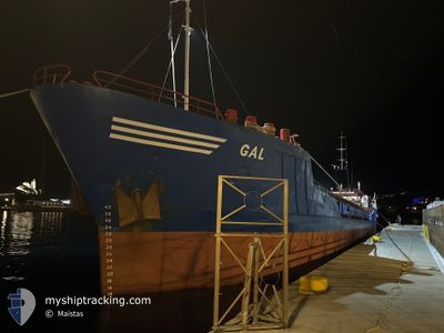
GAL
General Cargo
Current Trip
| Time Travelled | 7 days |
|---|---|
| Remaining Time | --- |
| Distance Travelled | 957.78 nm |
| Remaining Distance | --- |
| AVG Speed | 6 Knots |
| MAX Speed | 6 Knots |
| AVG Wind | 10 knots |
| MAX Wind | 21.6 knots |
| MIN Temp | 18.2°C / 64.76°F |
| MAX Temp | 30.1°C / 86.18°F |
| Draught | 1.6 m |
| Position Received | 3 m ago |
Current Position
| Longitude | 29.12374° |
|---|---|
| Latitude | 40.43156° |
| Status | At anchor |
| Speed | 0.1 Knots |
| Course | 63° |
| Area | Sea of Marmara |
| Station | T-AIS |
| Position Received | 3 m ago |
Info
Information
The current position of GAL is in Sea of Marmara with coordinates 40.43156° / 29.12374° as reported on 2024-06-18 13:46 by AIS to our vessel tracker app. The vessel's current speed is 0.1 Knots
The vessel GAL (IMO: 8502145, MMSI: 630001035) is a General Cargo that was built in 1986 ( 38 years old ). It's sailing under the flag of [GW] Guinea-Bissau.
In this page you can find informations about the vessels current position, last detected port calls, and current voyage information. If the vessels is not in coverage by AIS you will find the latest position.
The current position of GAL is detected by our AIS receivers and we are not responsible for the reliability of the data. The last position was recorded while the vessel was in Coverage by the Ais receivers of our vessel tracking app.
The current draught of GAL as reported by AIS is 1.6 meters
Weather
| Temperature | 28.7°C / 83.66°F |
|---|---|
| Wind Speed | 17 knots |
| Direction | 48° NE |
| Pressure | 1015.1 hPa |
| Humidity | 35.6 % |
| Cloud Coverage | --- |
Featured Company
Last Port Calls
| Port | Arrival | Departure | Time In Port |
|---|---|---|---|
| 2024-06-09 23:28 | 2024-06-10 18:01 | 18 h | |
| 2024-06-09 21:46 | 2024-06-09 23:26 | 1 h | |
| 2024-06-09 02:41 | 2024-06-09 02:43 | 2 m | |
| 2024-06-09 02:34 | 2024-06-09 02:36 | 2 m | |
| 2024-06-09 02:32 | 2024-06-09 02:33 | 0 m | |
| 2024-06-09 02:29 | 2024-06-09 02:30 | 1 m | |
| 2024-06-09 02:21 | 2024-06-09 02:26 | 5 m | |
| 2024-06-05 03:40 | 2024-06-05 03:43 | 2 m | |
| 2024-05-30 04:20 | 2024-05-31 12:48 | 1 d | |
| 2024-05-28 16:12 | 2024-05-29 04:40 | 12 h |
Most Visited Ports (Last year)
| Port | Arrivals | |
|---|---|---|
| 10 | ||
| 9 | ||
| 4 | ||
| 4 | ||
| 3 | ||
| 2 |
Last Trips
| Origin | Departure | Destination | Arrival | Distance | |
|---|---|---|---|---|---|
| 2024-06-10 02:26 | 2024-06-10 02:28 | 1.21 nm | |||
| 2024-06-09 05:43 | 2024-06-10 00:46 | 228.07 nm | |||
| 2024-06-09 05:36 | 2024-06-09 05:41 | 0.78 nm | |||
| 2024-06-09 05:33 | 2024-06-09 05:34 | 2.03 nm | |||
| 2024-06-09 05:33 | 2024-06-09 05:32 | 2.03 nm | |||
| 2024-06-09 05:26 | 2024-06-09 05:29 | 1.66 nm | |||
| 2024-06-05 06:43 | 2024-06-09 05:21 | 917.83 nm | |||
| 2024-05-31 15:48 | 2024-06-05 06:40 | 603.20 nm | |||
| 2024-05-29 07:40 | 2024-05-30 07:20 | 130.48 nm | |||
| 2024-05-26 09:14 | 2024-05-28 19:12 | 338.57 nm |
Events
| Time | Event | Details | Position / Dest | Info |
|---|---|---|---|---|
| 2024-06-18 12:28 | Status Changed | At anchor Default |
40.43160 / 29.12381
TR GEM
|
Speed: 0.5 kn Course: 45° |
| 2024-06-18 12:25 | Status Changed | Default At anchor |
40.43156 / 29.12394
TR GEM
|
Speed: 0.4 kn Course: 33° |
| 2024-06-18 07:46 | Status Changed | At anchor Default |
40.43184 / 29.12418
TR GEM
|
Speed: Course: 14° |
| 2024-06-18 07:37 | Status Changed | Default At anchor |
40.43189 / 29.12420
TR GEM
|
Speed: Course: 3° |
| 2024-06-18 07:16 | Status Changed | At anchor Default |
40.43180 / 29.12425
TR GEM
|
Speed: Course: 8° |
| 2024-06-18 07:07 | Status Changed | Default At anchor |
40.43191 / 29.12409
TR GEM
|
Speed: Course: 16° |
| 2024-06-18 06:40 | Status Changed | At anchor Default |
40.43204 / 29.12369
TR GEM
|
Speed: 0.1 kn Course: 66° |
| 2024-06-18 06:37 | Status Changed | Default At anchor |
40.43219 / 29.12362
TR GEM
|
Speed: 0.1 kn Course: 80° |
| 2024-06-18 01:16 | Status Changed | At anchor Default |
40.43246 / 29.12345
TR GEM
|
Speed: 0.3 kn Course: 85° |
| 2024-06-18 01:07 | Status Changed | Default At anchor |
40.43240 / 29.12340
TR GEM
|
Speed: Course: 76° |