
GAVRINIS
Dredging or underwater ops
Current Trip
Unknown
| Time Travelled | --- |
|---|---|
| Remaining Time | --- |
| Distance Travelled | 545.06 nm |
| Remaining Distance | --- |
| AVG Speed | 9.6 Knots |
| MAX Speed | 14.8 Knots |
| AVG Wind | 12.3 knots |
| MAX Wind | 27.6 knots |
| MIN Temp | 8.2°C / 46.76°F |
| MAX Temp | 17.3°C / 63.14°F |
| Draught | 0 m |
| Position Received | 1 m ago |
Current Position
| Longitude | -2.75222° |
|---|---|
| Latitude | 47.59181° |
| Status | Default |
| Speed | 0.3 Knots |
| Course | 228° |
| Area | Bay of Biscay |
| Station | T-AIS |
| Position Received | 1 m ago |
Info
Information
The current position of GAVRINIS is in Bay of Biscay with coordinates 47.59181° / -2.75222° as reported on 2024-05-29 07:44 by AIS to our vessel tracker app. The vessel's current speed is 0.3 Knots
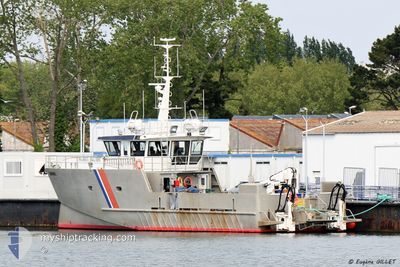
The vessel GAVRINIS (MMSI: 227820970) is a Dredging or underwater ops It's sailing under the flag of [FR] France.
In this page you can find informations about the vessels current position, last detected port calls, and current voyage information. If the vessels is not in coverage by AIS you will find the latest position.
The current position of GAVRINIS is detected by our AIS receivers and we are not responsible for the reliability of the data. The last position was recorded while the vessel was in Coverage by the Ais receivers of our vessel tracking app.
Weather
| Temperature | 16.1°C / 60.98°F |
|---|---|
| Wind Speed | 18 knots |
| Direction | 255° WSW |
| Pressure | 1014.2 hPa |
| Humidity | 95.4 % |
| Cloud Coverage | 100 % |
Featured Company
Events
| Time | Event | Details | Position / Dest | Info |
|---|---|---|---|---|
| 2024-05-29 06:51 | STOP Moving | 2.22 nm, South East of PORT ANNA |
47.59176 / -2.75233
|
Speed: 0.3 kn Course: 256° |
| 2024-05-29 06:13 | START Moving | 1.7 nm, South East of LE MOUSTOIR |
47.60363 / -2.82974
|
Speed: 9.7 kn Course: 190.5° |
| 2024-05-28 13:05 | STOP Moving | 1.59 nm, South East of LE MOUSTOIR |
47.60558 / -2.83088
|
Speed: 0.3 kn Course: 207° |
| 2024-05-28 12:34 | START Moving | 2.3 nm, South of PORT ANNA |
47.58664 / -2.76584
|
Speed: 6.9 kn Course: 246.7° |
| 2024-05-28 06:42 | STOP Moving | 2.29 nm, South of PORT ANNA |
47.58731 / -2.76327
|
Speed: 0.2 kn Course: 60° |
| 2024-05-28 06:13 | START Moving | 1.7 nm, South East of LE MOUSTOIR |
47.60367 / -2.82962
|
Speed: 8.9 kn Course: 182.5° |
| 2024-05-27 14:54 | STOP Moving | 1.61 nm, South East of LE MOUSTOIR |
47.60559 / -2.82999
|
Speed: 0.2 kn Course: 298° |
| 2024-05-27 13:29 | START Moving | 1.52 nm, North East of QUIBERON |
47.48826 / -3.09168
|
Speed: 9.1 kn Course: 75.3° |
| 2024-05-27 12:06 | STOP Moving | 1.4 nm, North East of QUIBERON |
47.48766 / -3.09460
|
Speed: 0.2 kn Course: 37° |
| 2024-05-27 09:33 | START Moving | 0.43 nm, North of LORIENT |
47.74524 / -3.34862
|
Speed: 3.3 kn Course: 175° |