
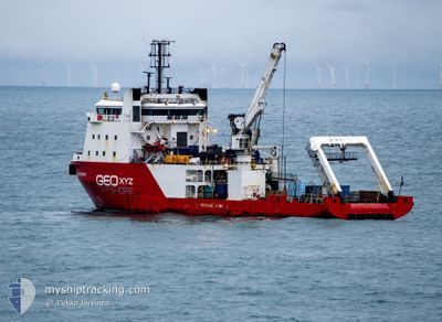
GEO OCEAN III
Offshore Supply Ship
Current Trip
SURVEY CPA 1 NM
| Time Travelled | 11 days |
|---|---|
| Remaining Time | --- |
| Distance Travelled | 653.58 nm |
| Remaining Distance | --- |
| AVG Speed | 4.8 Knots |
| MAX Speed | 9.5 Knots |
| AVG Wind | 7.4 knots |
| MAX Wind | 17.1 knots |
| MIN Temp | 9.7°C / 49.46°F |
| MAX Temp | 13.3°C / 55.94°F |
| Draught | 5.7 m |
| Position Received | 5 h, 7 m ago |
Current Position
| Longitude | -0.77006° |
|---|---|
| Latitude | 55.54156° |
| Status | Restricted manoeuverability |
| Speed | 4.3 Knots |
| Course | 158° |
| Area | North Sea |
| Station | T-AIS |
| Position Received | 5 h, 7 m ago |
Info
Information
The current position of GEO OCEAN III is in North Sea with coordinates 55.54156° / -0.77006° as reported on 2024-05-19 18:10 by AIS to our vessel tracker app. The vessel's current speed is 4.3 Knots
The vessel GEO OCEAN III (IMO: 9285586, MMSI: 253596000) is a Offshore Supply Ship that was built in 2004 ( 20 years old ). It's sailing under the flag of [LU] Luxembourg.
In this page you can find informations about the vessels current position, last detected port calls, and current voyage information. If the vessels is not in coverage by AIS you will find the latest position.
The current position of GEO OCEAN III is detected by our AIS receivers and we are not responsible for the reliability of the data. The last position was recorded while the vessel was in Coverage by the Ais receivers of our vessel tracking app.
The current draught of GEO OCEAN III as reported by AIS is 5.7 meters
Weather
| Temperature | 10.7°C / 51.26°F |
|---|---|
| Wind Speed | 8 knots |
| Direction | 23° NNE |
| Pressure | 1018.3 hPa |
| Humidity | 92.2 % |
| Cloud Coverage | 76 % |
Featured Company
Last Port Calls
| Port | Arrival | Departure | Time In Port |
|---|---|---|---|
| 2024-05-08 05:51 | 2024-05-08 17:11 | 11 h | |
| 2024-04-19 08:24 | 2024-04-21 09:24 | 2 d | |
| 2024-04-15 14:59 | 2024-04-17 12:20 | 1 d | |
| 2024-04-09 09:07 | 2024-04-11 05:14 | 1 d | |
| 2024-04-02 18:34 | 2024-04-03 17:30 | 22 h | |
| 2024-03-30 17:39 | 2024-04-02 09:41 | 2 d | |
| 2024-03-09 11:33 | 2024-03-30 11:12 | 20 d |
Most Visited Ports (Last year)
| Port | Arrivals | |
|---|---|---|
| 12 | ||
| 5 | ||
| 4 | ||
| 3 | ||
| 2 | ||
| 2 |
Last Trips
| Origin | Departure | Destination | Arrival | Distance | |
|---|---|---|---|---|---|
| 2024-04-21 10:24 | 2024-05-08 06:51 | 167.75 nm | |||
| 2024-04-17 13:20 | 2024-04-19 09:24 | 48.33 nm | |||
| 2024-04-11 06:14 | 2024-04-15 15:59 | 75.63 nm | |||
| 2024-04-03 19:30 | 2024-04-09 10:07 | 402.93 nm | |||
| 2024-04-02 11:41 | 2024-04-02 20:34 | 16.53 nm | |||
| 2024-03-30 12:12 | 2024-03-30 18:39 | 14.71 nm | |||
| 2024-02-27 11:24 | 2024-03-09 12:33 | 562.01 nm |
Events
| Time | Event | Details | Position / Dest | Info |
|---|---|---|---|---|
| 2024-05-19 18:10 | OUT of Coverage |
55.54156 / -.77006
North Sea
|
Speed: 4.3 kn Course: 158.5° |
|
| 2024-05-19 18:10 | IN Coverage |
55.54156 / -.77006
North Sea
|
Speed: 4.3 kn Course: 158.5° |
|
| 2024-05-19 16:37 | OUT of Coverage |
55.47697 / -.67064
North Sea
|
Speed: 5.3 kn Course: 316.7° |
|
| 2024-05-19 13:06 | START Moving |
55.63777 / -.81836
SURVEY CPA 1 NM
|
Speed: 3.1 kn Course: 134° |
|
| 2024-05-19 12:53 | STOP Moving |
55.63677 / -.82143
SURVEY CPA 1 NM
|
Speed: 0.3 kn Course: 358° |
|
| 2024-05-19 07:07 | IN Coverage |
55.44677 / -.64761
North Sea
|
Speed: 4.8 kn Course: 330.2° |
|
| 2024-05-19 05:54 | OUT of Coverage |
55.44266 / -.64356
North Sea
|
Speed: 3.8 kn Course: 150.5° |
|
| 2024-05-18 17:31 | Destination Changed | SURVEY CPA 1 NM SURVEY CPA 1NM |
55.43574 / -.63933
SURVEY CPA 1 NM
|
Speed: 3.9 kn Course: 144° |
| 2024-05-18 17:31 | ETA Changed | 2024/05/18 02:00 2024/05/08 23:00 |
55.43574 / -.63933
SURVEY CPA 1 NM
|
Speed: 3.9 kn Course: 144° |
| 2024-05-18 14:22 | OUT of Coverage |
55.38195 / -.56559
North Sea
|
Speed: 0.2 kn Course: 347.1° |