
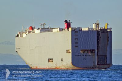
GEORGIA HIGHWAY
Vehicles Carrier
Current Trip
| Time Travelled | 2 days |
|---|---|
| Remaining Time | --- |
| Distance Travelled | 1240.30 nm |
| Remaining Distance | --- |
| AVG Speed | 17.2 Knots |
| MAX Speed | 19.1 Knots |
| AVG Wind | 8.6 knots |
| MAX Wind | 15.9 knots |
| MIN Temp | 12.1°C / 53.78°F |
| MAX Temp | 14.8°C / 58.64°F |
| Draught | 9.5 m |
| Position Received | 1 d ago |
Current Position
| Longitude | -6.29918° |
|---|---|
| Latitude | 49.40199° |
| Status | Under way using engine |
| Speed | 16.4 Knots |
| Course | 260° |
| Area | Celtic Sea |
| Station | T-AIS |
| Position Received | 1 d ago |
Info
Information
The current position of GEORGIA HIGHWAY is in Celtic Sea with coordinates 49.40199° / -6.29918° as reported on 2024-05-18 15:04 by AIS to our vessel tracker app. The vessel's current speed is 16.4 Knots and is heading at the port of BRUNSWICK. The estimated time of arrival as calculated by vessel tracking app is 2024-05-26 23:00 LT
The vessel GEORGIA HIGHWAY (IMO: 9339820, MMSI: 432629000) is a Vehicles Carrier that was built in 2007 ( 17 years old ). It's sailing under the flag of [JP] Japan.
In this page you can find informations about the vessels current position, last detected port calls, and current voyage information. If the vessels is not in coverage by AIS you will find the latest position.
The current position of GEORGIA HIGHWAY is detected by our AIS receivers and we are not responsible for the reliability of the data. The last position was recorded while the vessel was in Coverage by the Ais receivers of our vessel tracking app.
The current draught of GEORGIA HIGHWAY as reported by AIS is 9.5 meters
Weather
| Temperature | 12.8°C / 55.04°F |
|---|---|
| Wind Speed | 11 knots |
| Direction | 196° SSW |
| Pressure | 1016.5 hPa |
| Humidity | 78.1 % |
| Cloud Coverage | 100 % |
Featured Company
Last Port Calls
| Port | Arrival | Departure | Time In Port |
|---|---|---|---|
| 2024-05-15 11:46 | 2024-05-17 00:46 | 1 d | |
| 2024-05-11 05:19 | 2024-05-12 20:00 | 1 d | |
| 2024-05-08 11:39 | 2024-05-11 00:13 | 2 d | |
| 2024-05-06 02:59 | 2024-05-06 17:18 | 14 h | |
| 2024-04-30 16:47 | 2024-05-02 05:45 | 1 d | |
| 2024-03-22 21:03 | 2024-03-26 09:16 | 3 d | |
| 2024-03-17 06:26 | 2024-03-19 02:28 | 1 d | |
| 2024-03-15 08:37 | 2024-03-16 04:31 | 19 h | |
| 2024-03-14 22:14 | 2024-03-15 06:24 | 8 h | |
| 2024-03-07 04:30 | 2024-03-11 19:09 | 4 d |
Last Trips
| Origin | Departure | Destination | Arrival | Distance | |
|---|---|---|---|---|---|
| 2024-05-12 22:00 | 2024-05-15 13:46 | 357.39 nm | |||
| 2024-05-11 02:13 | 2024-05-11 07:19 | 55.46 nm | |||
| 2024-05-06 18:18 | 2024-05-08 13:39 | 596.15 nm | |||
| 2024-05-02 07:45 | 2024-05-06 03:59 | 1614.55 nm | |||
| 2024-03-26 18:16 | 2024-04-30 18:47 | 14737.22 nm | |||
| 2024-03-19 11:28 | 2024-03-23 06:03 | 496.51 nm | |||
| 2024-03-16 13:31 | 2024-03-17 15:26 | 202.19 nm | |||
| 2024-03-15 15:24 | 2024-03-15 17:37 | 21.14 nm | |||
| 2024-03-12 03:09 | 2024-03-15 07:14 | 1209.16 nm | |||
| 2024-03-02 21:01 | 2024-03-07 12:30 | 256.41 nm |
Events
| Time | Event | Details | Position / Dest | Info |
|---|---|---|---|---|
| 2024-05-18 15:11 | Status Changed | Default Under way using engine |
49.39669 / -6.34698
USSSI
|
Speed: 16.4 kn Course: 260° |
| 2024-05-18 15:04 | OUT of Coverage |
49.40199 / -6.29918
Celtic Sea
USSSI
|
Speed: 16.4 kn Course: 260° |
|
| 2024-05-18 15:03 | Status Changed | Under way using engine Default |
49.40287 / -6.29150
USSSI
|
Speed: 16.4 kn Course: 260° |
| 2024-05-18 14:55 | Status Changed | Default Under way using engine |
49.40912 / -6.23573
USSSI
|
Speed: 16.4 kn Course: 260° |
| 2024-05-18 14:23 | Status Changed | Under way using engine Default |
49.43371 / -6.01438
USSSI
|
Speed: 17.3 kn Course: 260° |
| 2024-05-18 14:02 | Status Changed | Default Under way using engine |
49.44935 / -5.86261
USSSI
|
Speed: 17.2 kn Course: 261° |
| 2024-05-18 13:10 | Status Changed | Under way using engine Default |
49.49392 / -5.43879
USSSI
|
Speed: 17.1 kn Course: 260° |
| 2024-05-18 13:07 | Status Changed | Default Under way using engine |
49.49166 / -5.46041
USSSI
|
Speed: 17.1 kn Course: 261° |
| 2024-05-18 13:00 | Change Sea Area | United Kingdom part of the Celtic Sea United Kingdom part of the English Channel |
49.49714 / -5.40835
Celtic Sea
USSSI
|
Speed: 17.1 kn Course: 261° |
| 2024-05-18 13:00 | Status Changed | Under way using engine Default |
49.49714 / -5.40835
USSSI
|
Speed: 17.1 kn Course: 261° |