
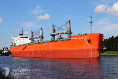
GLOBAL PRIME
Cargo
Current Trip
| Time Travelled | 3 days |
|---|---|
| Remaining Time | --- |
| Distance Travelled | 422.94 nm |
| Remaining Distance | --- |
| AVG Speed | 10.2 Knots |
| MAX Speed | 13.6 Knots |
| AVG Wind | 8.9 knots |
| MAX Wind | 19 knots |
| MIN Temp | 24.2°C / 75.56°F |
| MAX Temp | 27.4°C / 81.32°F |
| Draught | 7 m |
| Position Received | 20 m ago |
Current Position
| Longitude | 31.69327° |
|---|---|
| Latitude | 31.68577° |
| Status | At anchor |
| Speed | |
| Course | 292° |
| Area | Mediterranean Sea - Eastern Basin |
| Station | T-AIS |
| Position Received | 20 m ago |
Info
Information
The current position of GLOBAL PRIME is in Mediterranean Sea - Eastern Basin with coordinates 31.68577° / 31.69327° as reported on 2024-06-26 02:42 by AIS to our vessel tracker app. The vessel's current speed is 0 Knots
The vessel GLOBAL PRIME (IMO: 9658941, MMSI: 311000144) is a Cargo It's sailing under the flag of [BS] Bahamas.
In this page you can find informations about the vessels current position, last detected port calls, and current voyage information. If the vessels is not in coverage by AIS you will find the latest position.
The current position of GLOBAL PRIME is detected by our AIS receivers and we are not responsible for the reliability of the data. The last position was recorded while the vessel was in Coverage by the Ais receivers of our vessel tracking app.
The current draught of GLOBAL PRIME as reported by AIS is 7 meters
Weather
| Temperature | 25.5°C / 77.9°F |
|---|---|
| Wind Speed | 8 knots |
| Direction | 302° WNW |
| Pressure | 1006.5 hPa |
| Humidity | 74.6 % |
| Cloud Coverage | --- |
Featured Company
Last Port Calls
| Port | Arrival | Departure | Time In Port |
|---|---|---|---|
| 2024-06-17 15:21 | 2024-06-22 12:53 | 4 d | |
| 2024-06-01 15:31 | 2024-06-06 01:43 | 4 d | |
| 2024-05-30 10:37 | 2024-05-30 12:08 | 1 h | |
| 2024-05-25 11:48 | 2024-05-29 06:47 | 3 d | |
| 2024-05-02 20:02 | 2024-05-05 22:37 | 3 d | |
| 2024-04-24 12:01 | 2024-04-27 20:51 | 3 d |
Most Visited Ports (Last year)
| Port | Arrivals | |
|---|---|---|
| 3 | ||
| 2 | ||
| 1 | ||
| 1 | ||
| 1 | ||
| 1 |
Last Trips
| Origin | Departure | Destination | Arrival | Distance | |
|---|---|---|---|---|---|
| 2024-06-06 03:43 | 2024-06-17 18:21 | 3497.24 nm | |||
| 2024-05-30 14:08 | 2024-06-01 17:31 | 361.78 nm | |||
| 2024-05-29 08:47 | 2024-05-30 12:37 | 206.87 nm | |||
| 2024-05-05 17:37 | 2024-05-25 13:48 | 5539.81 nm | |||
| 2024-04-27 15:51 | 2024-05-02 15:02 | 558.81 nm | |||
| 2024-02-24 14:45 | 2024-04-24 07:01 | 14857.76 nm |
Events
| Time | Event | Details | Position / Dest | Info |
|---|---|---|---|---|
| 2024-06-26 02:48 | Status Changed | Default At anchor |
31.68580 / 31.69327
EG DAM
|
Speed: Course: 292° |
| 2024-06-26 02:36 | Status Changed | At anchor Default |
31.68569 / 31.69323
EG DAM
|
Speed: Course: 297° |
| 2024-06-26 02:27 | Status Changed | Default At anchor |
31.68573 / 31.69321
EG DAM
|
Speed: Course: 294° |
| 2024-06-26 02:03 | Status Changed | At anchor Default |
31.68559 / 31.69308
EG DAM
|
Speed: Course: 305° |
| 2024-06-26 02:03 | IN Coverage |
31.68559 / 31.69308
Mediterranean Sea - Eastern Basin
|
Speed: Course: 285.4° |
|
| 2024-06-26 00:57 | Status Changed | Default At anchor |
31.68581 / 31.69333
EG DAM
|
Speed: 0.1 kn Course: 301° |
| 2024-06-26 00:54 | Status Changed | At anchor Default |
31.68573 / 31.69327
EG DAM
|
Speed: Course: 308° |
| 2024-06-26 00:54 | OUT of Coverage |
31.68573 / 31.69327
Mediterranean Sea - Eastern Basin
|
Speed: 0.1 kn Course: 41.1° |
|
| 2024-06-26 00:33 | Status Changed | Default At anchor |
31.68563 / 31.69314
EG DAM
|
Speed: Course: 301° |
| 2024-06-26 00:30 | Status Changed | At anchor Default |
31.68570 / 31.69314
EG DAM
|
Speed: Course: 298° |