
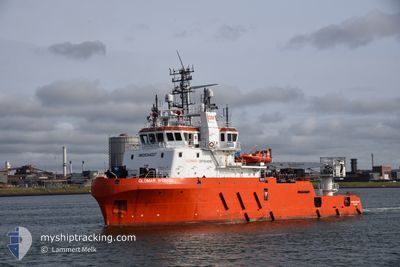
GLOMAR WORKER
Dredging or underwater ops
Current Trip
| Time Travelled | 9 h, 2 mins |
|---|---|
| Remaining Time | 3 days |
| Distance Travelled | 90.33 nm |
| Remaining Distance | 737.97 nm |
| AVG Speed | 10.2 Knots |
| MAX Speed | 11.7 Knots |
| AVG Wind | 16.5 knots |
| MAX Wind | 17.9 knots |
| MIN Temp | 10.7°C / 51.26°F |
| MAX Temp | 15.2°C / 59.36°F |
| Draught | 4.7 m |
| Position Received | 11 m ago |
Current Position
| Longitude | 17.20398° |
|---|---|
| Latitude | 54.91040° |
| Status | Under way using engine |
| Speed | 10.2 Knots |
| Course | 254.8° |
| Area | Baltic Sea |
| Station | T-AIS |
| Position Received | 11 m ago |
Info
Information
The current position of GLOMAR WORKER is in Baltic Sea with coordinates 54.91040° / 17.20398° as reported on 2024-05-17 02:11 by AIS to our vessel tracker app. The vessel's current speed is 10.2 Knots and is heading at the port of DEN HELDER. The estimated time of arrival as calculated by vessel tracking app is 2024-05-20 02:52 LT
The vessel GLOMAR WORKER (IMO: 9344227, MMSI: 352110000) is a Dredging or underwater ops It's sailing under the flag of [PA] Panama.
In this page you can find informations about the vessels current position, last detected port calls, and current voyage information. If the vessels is not in coverage by AIS you will find the latest position.
The current position of GLOMAR WORKER is detected by our AIS receivers and we are not responsible for the reliability of the data. The last position was recorded while the vessel was in Coverage by the Ais receivers of our vessel tracking app.
The current draught of GLOMAR WORKER as reported by AIS is 4.7 meters
Weather
| Temperature | 10.8°C / 51.44°F |
|---|---|
| Wind Speed | 14 knots |
| Direction | 115° ESE |
| Pressure | 1020 hPa |
| Humidity | 80.2 % |
| Cloud Coverage | 6 % |
Featured Company
Events
| Time | Event | Details | Position / Dest | Info |
|---|---|---|---|---|
| 2024-05-16 17:48 | Destination Changed | NLDHR KIEL CANAL I |
54.52730 / 18.68307
NLDHR
|
Speed: 9.7 kn Course: 89.9° |
| 2024-05-16 17:21 | PORT DEPARTURE |
|
54.51646 / 18.56515
KIEL CANAL I
|
Speed: 6.4 kn Course: 88° |
| 2024-05-16 17:16 | Status Changed | Under way using engine Moored |
54.52287 / 18.56057
[PL] GDYNIA
|
Speed: 5 kn Course: 177° |
| 2024-05-16 17:15 | START Moving |
54.52478 / 18.55985
[PL] GDYNIA
|
Speed: 3.8 kn Course: 126° |
|
| 2024-05-16 16:53 | ETA Changed | 2024/05/19 16:00 2024/05/13 16:00 |
54.52414 / 18.55681
[PL] GDYNIA
|
Speed: Course: 83° |
| 2024-05-16 16:47 | Destination Changed | KIEL CANAL I PLGDY |
54.52414 / 18.55679
[PL] GDYNIA
|
Speed: Course: 84° |
| 2024-05-15 00:30 | IN Coverage |
54.52406 / 18.55684
Baltic Sea
[PL] GDYNIA
|
Speed: 0.1 kn Course: 154.1° |
|
| 2024-05-14 23:18 | OUT of Coverage |
54.52406 / 18.55671
Baltic Sea
[PL] GDYNIA
|
Speed: 1.3 kn Course: 196.3° |
|
| 2024-05-14 14:10 | Status Changed | Moored Under way using engine |
54.52407 / 18.55673
[PL] GDYNIA
|
Speed: Course: 261° |
| 2024-05-14 13:55 | STOP Moving |
54.52439 / 18.55659
[PL] GDYNIA
|
Speed: 0.3 kn Course: 245° |