
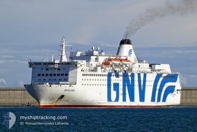
GNV ALLEGRA
Ro-Ro/Passenger Ship
Current Trip
| Trip Time | 12 h, 3 mins |
|---|---|
| Trip Distance | 215.15 nm |
| AVG Speed | 18 Knots |
| MAX Speed | 18.9 Knots |
| Draught | 6.5 m |
| AVG Wind | 9.5 knots |
| MAX Wind | 13 knots |
| MIN Temp | 19.1°C / 66.38°F |
| MAX Temp | 20.6°C / 69.08°F |
| Position Received | 8 h, 24 m ago |
Current Position
| Longitude | 8.40021° |
|---|---|
| Latitude | 41.72769° |
| Status | Under way using engine |
| Speed | 18 Knots |
| Course | 174.7° |
| Area | Mediterranean Sea - Western Basin |
| Station | T-AIS |
| Position Received | 8 h, 24 m ago |
Info
Information
The current position of GNV ALLEGRA is in Mediterranean Sea - Western Basin with coordinates 41.72769° / 8.40021° as reported on 2024-06-16 02:24 by AIS to our vessel tracker app. The vessel's current speed is 18 Knots and is currently inside the port of PORTO TORRES.
The vessel GNV ALLEGRA (IMO: 8506311, MMSI: 247392600) is a Ro-Ro/Passenger Ship that was built in 1987 ( 37 years old ). It's sailing under the flag of [IT] Italy.
In this page you can find informations about the vessels current position, last detected port calls, and current voyage information. If the vessels is not in coverage by AIS you will find the latest position.
The current position of GNV ALLEGRA is detected by our AIS receivers and we are not responsible for the reliability of the data. The last position was recorded while the vessel was in Coverage by the Ais receivers of our vessel tracking app.
The current draught of GNV ALLEGRA as reported by AIS is 6.5 meters
Weather
| Temperature | 25.2°C / 77.36°F |
|---|---|
| Wind Speed | 8 knots |
| Direction | 337° NNW |
| Pressure | 1013.6 hPa |
| Humidity | 47.9 % |
| Cloud Coverage | 86 % |
Featured Company
Last Port Calls
| Port | Arrival | Departure | Time In Port |
|---|---|---|---|
| 2024-06-16 05:28 | |||
| 2024-06-15 12:40 | 2024-06-15 17:25 | 4 h | |
| 2024-06-15 04:36 | 2024-06-15 08:56 | 4 h | |
| 2024-06-14 05:39 | 2024-06-14 16:45 | 11 h | |
| 2024-06-13 04:49 | 2024-06-13 17:41 | 12 h | |
| 2024-06-12 05:32 | 2024-06-12 16:41 | 11 h | |
| 2024-06-11 04:29 | 2024-06-11 17:35 | 13 h | |
| 2024-06-10 05:26 | 2024-06-10 16:46 | 11 h | |
| 2024-06-09 04:36 | 2024-06-09 17:22 | 12 h | |
| 2024-06-08 05:37 | 2024-06-08 16:37 | 11 h |
Most Visited Ports (Last year)
| Port | Arrivals | |
|---|---|---|
| 77 | ||
| 63 | ||
| 5 | ||
| 5 | ||
| 3 | ||
| 1 |
Last Trips
| Origin | Departure | Destination | Arrival | Distance | |
|---|---|---|---|---|---|
| 2024-06-15 19:25 | 2024-06-16 07:28 | 215.15 nm | |||
| 2024-06-15 10:56 | 2024-06-15 14:40 | 30.12 nm | |||
| 2024-06-14 18:45 | 2024-06-15 06:36 | 215.22 nm | |||
| 2024-06-13 19:41 | 2024-06-14 07:39 | 216.38 nm | |||
| 2024-06-12 18:41 | 2024-06-13 06:49 | 215.79 nm | |||
| 2024-06-11 19:35 | 2024-06-12 07:32 | 227.77 nm | |||
| 2024-06-10 18:46 | 2024-06-11 06:29 | 215.38 nm | |||
| 2024-06-09 19:22 | 2024-06-10 07:26 | 216.23 nm | |||
| 2024-06-08 18:37 | 2024-06-09 06:36 | 211.39 nm | |||
| 2024-06-07 19:25 | 2024-06-08 07:37 | 213.91 nm |
Events
| Time | Event | Details | Position / Dest | Info |
|---|---|---|---|---|
| 2024-06-16 05:46 | STOP Moving |
40.84167 / 8.39333
[IT] PORTO TORRES
|
Speed: Course: -1° |
|
| 2024-06-16 05:28 | PORT ARRIVAL |
|
40.84333 / 8.39500
[IT] PORTO TORRES
|
Speed: 17 kn Course: 175° |
| 2024-06-16 03:16 | Status Changed | Default Under way using engine |
41.47666 / 8.42666
ITPTO
|
Speed: 18 kn Course: 174.7° |
| 2024-06-16 02:24 | OUT of Coverage |
41.72769 / 8.40021
Mediterranean Sea - Western Basin
ITPTO
|
Speed: 18 kn Course: 174.7° |
|
| 2024-06-16 00:54 | Status Changed | Under way using engine Default |
42.17271 / 8.34431
ITPTO
|
Speed: 17 kn Course: 174° |
| 2024-06-16 00:43 | IN Coverage |
42.16925 / 8.34477
Mediterranean Sea - Western Basin
ITPTO
|
Speed: 17.8 kn Course: 174.3° |
|
| 2024-06-15 23:52 | Status Changed | Default Under way using engine |
42.46500 / 8.37167
ITPTO
|
Speed: 18.1 kn Course: 193.7° |
| 2024-06-15 23:21 | Status Changed | Under way using engine Default |
42.61449 / 8.42074
ITPTO
|
Speed: 18 kn Course: 193° |
| 2024-06-15 23:21 | OUT of Coverage |
42.61449 / 8.42074
Mediterranean Sea - Western Basin
ITPTO
|
Speed: 18.1 kn Course: 193.7° |
|
| 2024-06-15 23:16 | Status Changed | Default Under way using engine |
42.64167 / 8.42833
ITPTO
|
Speed: 18.1 kn Course: 193.2° |