
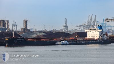
GOLDEN FROST
Cargo
Current Trip
| Time Travelled | 18 days |
|---|---|
| Remaining Time | --- |
| Distance Travelled | 5119.15 nm |
| Remaining Distance | 33.72 nm |
| AVG Speed | 12 Knots |
| MAX Speed | 14.8 Knots |
| AVG Wind | 13.8 knots |
| MAX Wind | 40 knots |
| MIN Temp | 4.2°C / 39.56°F |
| MAX Temp | 28.6°C / 83.48°F |
| Draught | 7.9 m |
| Position Received | 10 m ago |
Current Position
| Longitude | -94.49094° |
|---|---|
| Latitude | 29.27313° |
| Status | At anchor |
| Speed | 0.1 Knots |
| Course | 165° |
| Area | Gulf of Mexico |
| Station | T-AIS |
| Position Received | 10 m ago |
Info
Information
The current position of GOLDEN FROST is in Gulf of Mexico with coordinates 29.27313° / -94.49094° as reported on 2024-05-20 02:55 by AIS to our vessel tracker app. The vessel's current speed is 0.1 Knots and is heading at the port of HOUSTON. The estimated time of arrival as calculated by vessel tracking app is 2024-05-19 10:00 LT
The vessel GOLDEN FROST (IMO: 9849899, MMSI: 538009063) is a Cargo It's sailing under the flag of [MH] Marshall Is.
In this page you can find informations about the vessels current position, last detected port calls, and current voyage information. If the vessels is not in coverage by AIS you will find the latest position.
The current position of GOLDEN FROST is detected by our AIS receivers and we are not responsible for the reliability of the data. The last position was recorded while the vessel was in Coverage by the Ais receivers of our vessel tracking app.
The current draught of GOLDEN FROST as reported by AIS is 7.9 meters
Weather
| Temperature | 26.1°C / 78.98°F |
|---|---|
| Wind Speed | 12 knots |
| Direction | 143° SE |
| Pressure | 1011.8 hPa |
| Humidity | 79.2 % |
| Cloud Coverage | --- |
Featured Company
Last Port Calls
| Port | Arrival | Departure | Time In Port |
|---|---|---|---|
| 2024-04-26 23:20 | 2024-05-01 23:58 | 5 d | |
| 2024-04-19 20:00 | 2024-04-23 00:08 | 3 d | |
| 2024-04-11 09:02 | 2024-04-15 16:01 | 4 d | |
| 2024-03-24 01:23 | 2024-03-29 00:54 | 4 d | |
| 2024-03-07 23:07 | 2024-03-09 04:54 | 1 d |
Most Visited Ports (Last year)
| Port | Arrivals | |
|---|---|---|
| 3 | ||
| 2 | ||
| 2 | ||
| 2 | ||
| 1 | ||
| 1 |
Last Trips
| Origin | Departure | Destination | Arrival | Distance | |
|---|---|---|---|---|---|
| 2024-04-23 02:08 | 2024-04-27 01:20 | 1045.32 nm | |||
| 2024-04-15 18:01 | 2024-04-19 22:00 | 1104.43 nm | |||
| 2024-03-29 01:54 | 2024-04-11 11:02 | 1401.14 nm | |||
| 2024-03-08 23:54 | 2024-03-24 02:23 | 3252.90 nm | |||
| 2024-02-27 14:49 | 2024-03-07 18:07 | 68.90 nm |
Events
| Time | Event | Details | Position / Dest | Info |
|---|---|---|---|---|
| 2024-05-20 03:02 | Status Changed | Default At anchor |
29.27314 / -94.49092
US HOU
|
Speed: 0.1 kn Course: 165° |
| 2024-05-20 01:58 | Status Changed | At anchor Default |
29.27306 / -94.49111
US HOU
|
Speed: 0.1 kn Course: 154° |
| 2024-05-20 01:52 | Status Changed | Default At anchor |
29.27304 / -94.49129
US HOU
|
Speed: Course: 156° |
| 2024-05-20 01:49 | Status Changed | At anchor Default |
29.27299 / -94.49126
US HOU
|
Speed: Course: 157° |
| 2024-05-20 01:46 | Status Changed | Default At anchor |
29.27298 / -94.49125
US HOU
|
Speed: 0.1 kn Course: 152° |
| 2024-05-20 01:07 | Status Changed | At anchor Default |
29.27277 / -94.49163
US HOU
|
Speed: 0.1 kn Course: 140° |
| 2024-05-20 01:04 | Status Changed | Default At anchor |
29.27275 / -94.49168
US HOU
|
Speed: 0.1 kn Course: 141° |
| 2024-05-20 00:55 | Status Changed | At anchor Default |
29.27273 / -94.49163
US HOU
|
Speed: 0.1 kn Course: 145° |
| 2024-05-20 00:52 | Status Changed | Default At anchor |
29.27274 / -94.49159
US HOU
|
Speed: 0.1 kn Course: 148° |
| 2024-05-20 00:49 | Status Changed | At anchor Default |
29.27278 / -94.49154
US HOU
|
Speed: 0.1 kn Course: 148° |