
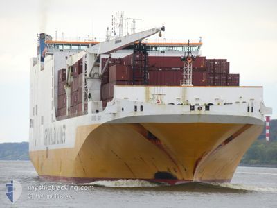
GRANDE TOGO
Ro-Ro Cargo
Current Trip
| Time Travelled | 1 day |
|---|---|
| Remaining Time | --- |
| Distance Travelled | 168.33 nm |
| Remaining Distance | --- |
| AVG Speed | 13.3 Knots |
| MAX Speed | 17 Knots |
| AVG Wind | 9.6 knots |
| MAX Wind | 17 knots |
| MIN Temp | 10.8°C / 51.44°F |
| MAX Temp | 16.2°C / 61.16°F |
| Draught | 8.5 m |
| Position Received | 21 h, 29 m ago |
Current Position
| Longitude | -72.96240° |
|---|---|
| Latitude | 40.41360° |
| Status | Under way using engine |
| Speed | 14.7 Knots |
| Course | 78° |
| Area | North Atlantic Ocean |
| Station | T-AIS |
| Position Received | 21 h, 29 m ago |
Info
Information
The current position of GRANDE TOGO is in North Atlantic Ocean with coordinates 40.41360° / -72.96240° as reported on 2024-05-18 01:00 by AIS to our vessel tracker app. The vessel's current speed is 14.7 Knots
The vessel GRANDE TOGO (IMO: 9465370, MMSI: 247304200) is a Ro-Ro Cargo that was built in 2011 ( 13 years old ). It's sailing under the flag of [IT] Italy.
In this page you can find informations about the vessels current position, last detected port calls, and current voyage information. If the vessels is not in coverage by AIS you will find the latest position.
The current position of GRANDE TOGO is detected by our AIS receivers and we are not responsible for the reliability of the data. The last position was recorded while the vessel was in Coverage by the Ais receivers of our vessel tracking app.
The current draught of GRANDE TOGO as reported by AIS is 8.5 meters
Weather
| Temperature | 11.3°C / 52.34°F |
|---|---|
| Wind Speed | 16 knots |
| Direction | 29° NNE |
| Pressure | 1014.8 hPa |
| Humidity | 94.7 % |
| Cloud Coverage | 100 % |
Featured Company
Last Port Calls
| Port | Arrival | Departure | Time In Port |
|---|---|---|---|
| 2024-05-17 10:49 | 2024-05-17 21:23 | 10 h | |
| 2024-05-11 07:16 | 2024-05-12 09:44 | 1 d | |
| 2024-05-05 10:05 | 2024-05-05 23:09 | 13 h | |
| 2024-04-22 20:15 | 2024-04-24 00:41 | 1 d | |
| 2024-04-11 10:02 | 2024-04-12 19:07 | 1 d | |
| 2024-04-07 23:06 | 2024-04-08 17:40 | 18 h | |
| 2024-04-04 04:14 | 2024-04-04 20:48 | 16 h | |
| 2024-03-29 23:31 | 2024-03-31 02:32 | 1 d | |
| 2024-03-20 08:48 | 2024-03-20 22:55 | 14 h | |
| 2024-03-13 05:01 | 2024-03-14 09:44 | 1 d |
Last Trips
| Origin | Departure | Destination | Arrival | Distance | |
|---|---|---|---|---|---|
| 2024-05-12 04:44 | 2024-05-17 06:49 | 2184.16 nm | |||
| 2024-05-05 19:09 | 2024-05-11 02:16 | 2117.01 nm | |||
| 2024-04-23 19:41 | 2024-05-05 06:05 | 2149.29 nm | |||
| 2024-04-12 15:07 | 2024-04-22 15:15 | 2377.19 nm | |||
| 2024-04-08 13:40 | 2024-04-11 06:02 | 188.61 nm | |||
| 2024-04-04 16:48 | 2024-04-07 19:06 | 1017.60 nm | |||
| 2024-03-30 20:32 | 2024-04-04 00:14 | 1499.33 nm | |||
| 2024-03-20 18:55 | 2024-03-29 17:31 | 2205.93 nm | |||
| 2024-03-14 03:44 | 2024-03-20 04:48 | 2122.85 nm | |||
| 2024-03-08 01:23 | 2024-03-12 23:01 | 923.65 nm |
Events
| Time | Event | Details | Position / Dest | Info |
|---|---|---|---|---|
| 2024-05-18 09:37 | STOP Moving | 8.57 nm, South of NEWPORT (RI) |
41.34233 / -71.30343
USNYC>USDVV
|
Speed: 0.1 kn Course: 42° |
| 2024-05-18 01:04 | Status Changed | Default Under way using engine |
40.41672 / -72.94276
USNYC>USDVV
|
Speed: 14.7 kn Course: 78° |
| 2024-05-18 01:00 | Status Changed | Under way using engine Default |
40.41360 / -72.96240
USNYC>USDVV
|
Speed: 14.5 kn Course: 76° |
| 2024-05-18 01:00 | OUT of Coverage |
40.41360 / -72.96240
North Atlantic Ocean
USNYC>USDVV
|
Speed: 14.7 kn Course: 78° |
|
| 2024-05-18 00:47 | IN Coverage |
40.41360 / -72.96240
North Atlantic Ocean
USNYC>USDVV
|
Speed: 14.7 kn Course: 78° |
|
| 2024-05-18 00:07 | Status Changed | Default Under way using engine |
40.37588 / -73.24486
USNYC>USDVV
|
Speed: 14.9 kn Course: 99.5° |
| 2024-05-17 23:56 | OUT of Coverage |
40.38142 / -73.30238
North Atlantic Ocean
USNYC>USDVV
|
Speed: 14.9 kn Course: 99.5° |
|
| 2024-05-17 23:50 | Status Changed | Under way using engine Default |
40.38507 / -73.33384
USNYC>USDVV
|
Speed: 15.1 kn Course: 100° |
| 2024-05-17 23:44 | Status Changed | Default Under way using engine |
40.38976 / -73.36568
USNYC>USDVV
|
Speed: 15.1 kn Course: 99.3° |
| 2024-05-17 21:23 | PORT DEPARTURE |
|
40.57742 / -74.03189
USNYC>USDVV
|
Speed: 16.2 kn Course: 166° |