
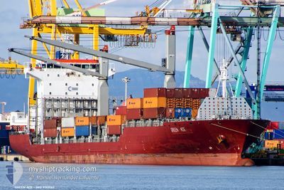
GREEN ACE
Container Ship
Current Trip
| Time Travelled | 7 days |
|---|---|
| Remaining Time | --- |
| Distance Travelled | 2368.12 nm |
| Remaining Distance | 1146.24 nm |
| AVG Speed | 14.2 Knots |
| MAX Speed | 14.2 Knots |
| AVG Wind | 8.6 knots |
| MAX Wind | 17.2 knots |
| MIN Temp | 26.4°C / 79.52°F |
| MAX Temp | 30.7°C / 87.26°F |
| Draught | 8 m |
| Position Received | 1 d ago |
Current Position
| Longitude | 77.18448° |
|---|---|
| Latitude | 7.53690° |
| Status | Under way using engine |
| Speed | 16.6 Knots |
| Course | 131° |
| Area | Laccadive Sea |
| Station | T-AIS |
| Position Received | 1 d ago |
Info
Information
The current position of GREEN ACE is in Laccadive Sea with coordinates 7.53690° / 77.18448° as reported on 2024-05-15 07:28 by AIS to our vessel tracker app. The vessel's current speed is 16.6 Knots and is heading at the port of TANJUNG PELEPAS. The estimated time of arrival as calculated by vessel tracking app is 2024-05-20 01:00 LT
The vessel GREEN ACE (IMO: 9309162, MMSI: 636019697) is a Container Ship that was built in 2005 ( 19 years old ). It's sailing under the flag of [LR] Liberia.
In this page you can find informations about the vessels current position, last detected port calls, and current voyage information. If the vessels is not in coverage by AIS you will find the latest position.
The current position of GREEN ACE is detected by our AIS receivers and we are not responsible for the reliability of the data. The last position was recorded while the vessel was in Coverage by the Ais receivers of our vessel tracking app.
The current draught of GREEN ACE as reported by AIS is 8 meters
Weather
| Temperature | 29.4°C / 84.92°F |
|---|---|
| Wind Speed | 11 knots |
| Direction | 224° SW |
| Pressure | 1010.2 hPa |
| Humidity | 76.2 % |
| Cloud Coverage | 100 % |
Featured Company
Last Port Calls
| Port | Arrival | Departure | Time In Port |
|---|---|---|---|
| 2024-05-09 14:37 | 2024-05-10 03:16 | 12 h | |
| 2024-05-07 20:33 | 2024-05-08 07:01 | 10 h | |
| 2024-05-06 07:39 | 2024-05-06 14:00 | 6 h | |
| 2024-05-05 01:27 | 2024-05-05 09:06 | 7 h | |
| 2024-05-03 11:48 | 2024-05-04 16:15 | 1 d | |
| 2024-04-30 15:52 | 2024-05-01 04:20 | 12 h | |
| 2024-04-26 11:20 | 2024-04-27 06:56 | 19 h | |
| 2024-04-23 21:51 | 2024-04-24 22:06 | 1 d | |
| 2024-04-18 07:04 | 2024-04-18 17:44 | 10 h | |
| 2024-04-13 12:32 | 2024-04-16 10:52 | 2 d |
Most Visited Ports (Last year)
| Port | Arrivals | |
|---|---|---|
| 9 | ||
| 8 | ||
| 7 | ||
| 6 | ||
| 6 | ||
| 4 |
Last Trips
| Origin | Departure | Destination | Arrival | Distance | |
|---|---|---|---|---|---|
| 2024-05-08 10:01 | 2024-05-09 18:37 | 341.89 nm | |||
| 2024-05-06 18:00 | 2024-05-07 23:33 | 353.78 nm | |||
| 2024-05-05 12:06 | 2024-05-06 11:39 | 281.14 nm | |||
| 2024-05-04 19:15 | 2024-05-05 04:27 | 96.52 nm | |||
| 2024-05-01 08:20 | 2024-05-03 14:48 | 597.52 nm | |||
| 2024-04-27 12:26 | 2024-04-30 19:52 | 995.06 nm | |||
| 2024-04-25 03:36 | 2024-04-26 16:50 | 429.82 nm | |||
| 2024-04-18 20:44 | 2024-04-24 03:21 | 1231.32 nm | |||
| 2024-04-16 13:52 | 2024-04-18 10:04 | 101.63 nm | |||
| 2024-04-12 03:58 | 2024-04-13 15:32 | 529.92 nm |
Events
| Time | Event | Details | Position / Dest | Info |
|---|---|---|---|---|
| 2024-05-15 07:35 | Status Changed | Default Under way using engine |
7.51498 / 77.21137
MYTPP
|
Speed: 16.6 kn Course: 131° |
| 2024-05-15 07:28 | OUT of Coverage |
7.53690 / 77.18448
Laccadive Sea
MYTPP
|
Speed: 16.6 kn Course: 131° |
|
| 2024-05-15 05:36 | Draught Changed | 8 7.7 |
7.87606 / 76.81048
MYTPP
|
Speed: 16.4 kn Course: 130.9° |
| 2024-05-15 05:36 | ETA Changed | 2024/05/20 01:00 2024/05/20 02:00 |
7.87606 / 76.81048
MYTPP
|
Speed: 16.4 kn Course: 130.9° |
| 2024-05-15 04:42 | Change Sea Area | Indian part of the Laccadive Sea Iranian part of the Gulf of Oman |
8.02650 / 76.61073
Laccadive Sea
MYTPP
|
Speed: 16.4 kn Course: 116.4° |
| 2024-05-15 04:42 | Status Changed | Under way using engine Default |
8.02650 / 76.61073
MYTPP
|
Speed: 16.5 kn Course: 129° |
| 2024-05-15 04:42 | IN Coverage |
8.02650 / 76.61073
Laccadive Sea
MYTPP
|
Speed: 16.4 kn Course: 116.4° |
|
| 2024-05-11 07:56 | Status Changed | Default At anchor |
25.10174 / 57.36987
MYTPP
|
Speed: 17.3 kn Course: 131.2° |
| 2024-05-11 07:51 | OUT of Coverage |
25.11753 / 57.34995
Gulf of Oman
MYTPP
|
Speed: 17.3 kn Course: 131.2° |
|
| 2024-05-11 05:08 | Change Sea Area | Iranian part of the Gulf of Oman Omani part of the Gulf of Oman |
25.71263 / 56.85058
Gulf of Oman
MYTPP
|
Speed: 16.9 kn Course: 159.1° |