
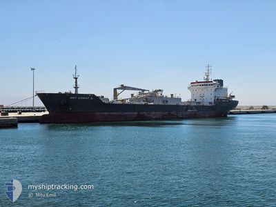
GRIT CEMENT III
Cement Carrier
Current Trip
| Time Travelled | 4 days |
|---|---|
| Remaining Time | 1 day |
| Distance Travelled | 1328.43 nm |
| Remaining Distance | 516.50 nm |
| AVG Speed | 11 Knots |
| MAX Speed | 13.8 Knots |
| AVG Wind | 13.3 knots |
| MAX Wind | 20 knots |
| MIN Temp | 11.5°C / 52.7°F |
| MAX Temp | 18.2°C / 64.76°F |
| Draught | 8.9 m |
| Position Received | 1 m ago |
Current Position
| Longitude | -9.22462° |
|---|---|
| Latitude | 36.55040° |
| Status | Under way using engine |
| Speed | 11 Knots |
| Course | 105.6° |
| Area | North Atlantic Ocean |
| Station | T-AIS |
| Position Received | 1 m ago |
Info
Information
The current position of GRIT CEMENT III is in North Atlantic Ocean with coordinates 36.55040° / -9.22462° as reported on 2024-06-06 10:14 by AIS to our vessel tracker app. The vessel's current speed is 11 Knots and is heading at the port of ALICANTE. The estimated time of arrival as calculated by vessel tracking app is 2024-06-08 09:51 LT
The vessel GRIT CEMENT III (IMO: 9116515, MMSI: 352003075) is a Cement Carrier that was built in 1996 ( 28 years old ). It's sailing under the flag of [PA] Panama.
In this page you can find informations about the vessels current position, last detected port calls, and current voyage information. If the vessels is not in coverage by AIS you will find the latest position.
The current position of GRIT CEMENT III is detected by our AIS receivers and we are not responsible for the reliability of the data. The last position was recorded while the vessel was in Coverage by the Ais receivers of our vessel tracking app.
The current draught of GRIT CEMENT III as reported by AIS is 8.9 meters
Weather
| Temperature | 18.1°C / 64.58°F |
|---|---|
| Wind Speed | 16 knots |
| Direction | 359° N |
| Pressure | 1013.3 hPa |
| Humidity | 81 % |
| Cloud Coverage | 100 % |
Featured Company
Last Trips
| Origin | Departure | Destination | Arrival | Distance | |
|---|---|---|---|---|---|
| 2024-05-20 13:44 | 2024-05-28 08:42 | 1846.01 nm | |||
| 2024-04-22 14:30 | 2024-05-04 14:14 | 1834.93 nm | |||
| 2024-04-08 01:21 | 2024-04-15 17:59 | 1868.65 nm | |||
| 2024-03-24 12:00 | 2024-04-03 11:37 | 2006.85 nm |
Events
| Time | Event | Details | Position / Dest | Info |
|---|---|---|---|---|
| 2024-06-06 03:16 | Status Changed | Under way using engine Default |
37.70171 / -9.81608
ES ALC
|
Speed: 11.7 kn Course: 165° |
| 2024-06-06 03:08 | Status Changed | Default Under way using engine |
37.72590 / -9.82437
ES ALC
|
Speed: 11.5 kn Course: 165.4° |
| 2024-06-05 14:55 | Status Changed | Under way using engine Default |
40.01811 / -10.10776
ES ALC
|
Speed: 11.4 kn Course: 179° |
| 2024-06-05 14:11 | Status Changed | Default Under way using engine |
40.15680 / -10.10849
ES ALC
|
Speed: 11.9 kn Course: 180.8° |
| 2024-06-05 10:51 | Status Changed | Under way using engine Default |
40.79538 / -10.10761
ES ALC
|
Speed: 11.7 kn Course: 180° |
| 2024-06-05 10:43 | Status Changed | Default Under way using engine |
40.82187 / -10.10803
ES ALC
|
Speed: 11.5 kn Course: 180.3° |
| 2024-06-05 09:35 | Change Sea Area | Portuguese part of the North Atlantic Ocean Spanish part of the North Atlantic Ocean |
41.03912 / -10.10712
North Atlantic Ocean
ES ALC
|
Speed: 11.5 kn Course: 177.8° |
| 2024-06-05 09:33 | Status Changed | Under way using engine Default |
41.04444 / -10.10735
ES ALC
|
Speed: 11.5 kn Course: 180° |
| 2024-06-05 09:33 | IN Coverage |
41.03912 / -10.10712
North Atlantic Ocean
ES ALC
|
Speed: 11.5 kn Course: 177.8° |
|
| 2024-06-04 22:49 | OUT of Coverage |
43.05264 / -10.10548
North Atlantic Ocean
ES ALC
|
Speed: 11.4 kn Course: 177.6° |