
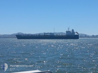
HAFNIA AMBER
Tanker B
Current Trip
| Time Travelled | 55 days |
|---|---|
| Remaining Time | --- |
| Distance Travelled | 6673.08 nm |
| Remaining Distance | --- |
| AVG Speed | 11.8 Knots |
| MAX Speed | 14.6 Knots |
| AVG Wind | 12 knots |
| MAX Wind | 27.8 knots |
| MIN Temp | 8.9°C / 48.02°F |
| MAX Temp | 30.9°C / 87.62°F |
| Draught | 10 m |
| Position Received | 22 m ago |
Current Position
| Longitude | -123.74039° |
|---|---|
| Latitude | 37.40411° |
| Status | Under way using engine |
| Speed | 8.5 Knots |
| Course | 292.9° |
| Area | North Pacific Ocean |
| Station | T-AIS |
| Position Received | 22 m ago |
Info
Information
The current position of HAFNIA AMBER is in North Pacific Ocean with coordinates 37.40411° / -123.74039° as reported on 2024-06-19 19:08 by AIS to our vessel tracker app. The vessel's current speed is 8.5 Knots and is heading at the port of SAN FRANCISCO.
The vessel HAFNIA AMBER (IMO: 9714056, MMSI: 538005771) is a Tanker B It's sailing under the flag of [MH] Marshall Is.
In this page you can find informations about the vessels current position, last detected port calls, and current voyage information. If the vessels is not in coverage by AIS you will find the latest position.
The current position of HAFNIA AMBER is detected by our AIS receivers and we are not responsible for the reliability of the data. The last position was recorded while the vessel was in Coverage by the Ais receivers of our vessel tracking app.
The current draught of HAFNIA AMBER as reported by AIS is 10 meters
Weather
| Temperature | 12.3°C / 54.14°F |
|---|---|
| Wind Speed | 12 knots |
| Direction | 307° NW |
| Pressure | 1014.2 hPa |
| Humidity | 91 % |
| Cloud Coverage | 90 % |
Featured Company
Last Port Calls
| Port | Arrival | Departure | Time In Port |
|---|---|---|---|
| 2024-04-22 19:01 | 2024-04-24 22:34 | 2 d | |
| 2024-04-11 16:13 | 2024-04-13 09:32 | 1 d | |
| 2024-04-08 19:31 | 2024-04-10 19:34 | 2 d | |
| 2024-04-06 15:40 | 2024-04-08 19:05 | 2 d | |
| 2024-04-01 12:54 | 2024-04-01 13:25 | 31 m |
Last Trips
| Origin | Departure | Destination | Arrival | Distance | |
|---|---|---|---|---|---|
| 2024-04-13 10:32 | 2024-04-22 20:01 | 1755.57 nm | |||
| 2024-04-10 20:34 | 2024-04-11 17:13 | 21.00 nm | |||
| 2024-04-08 20:05 | 2024-04-08 20:31 | 2.99 nm | |||
| 2024-04-01 15:25 | 2024-04-06 16:40 | 722.53 nm | |||
| 2024-03-16 16:40 | 2024-04-01 14:54 | 1255.26 nm |
Events
| Time | Event | Details | Position / Dest | Info |
|---|---|---|---|---|
| 2024-06-19 19:14 | Status Changed | Default Under way using engine |
37.40976 / -123.75590
USSFO
|
Speed: 8.5 kn Course: 292.9° |
| 2024-06-19 19:07 | Status Changed | Under way using engine Default |
37.40313 / -123.73771
USSFO
|
Speed: 8.6 kn Course: 297° |
| 2024-06-19 18:56 | Status Changed | Default Under way using engine |
37.39102 / -123.70582
USSFO
|
Speed: 8.6 kn Course: 293.8° |
| 2024-06-19 18:50 | Status Changed | Under way using engine Default |
37.38506 / -123.69029
USSFO
|
Speed: 8.6 kn Course: 292° |
| 2024-06-19 18:13 | Status Changed | Default Under way using engine |
37.34243 / -123.58362
USSFO
|
Speed: 11.1 kn Course: 298.4° |
| 2024-06-19 17:37 | Status Changed | Under way using engine Default |
37.29379 / -123.46351
USSFO
|
Speed: 8.8 kn Course: 297° |
| 2024-06-19 17:30 | Status Changed | Default Under way using engine |
37.28648 / -123.44622
USSFO
|
Speed: 8.8 kn Course: 300.5° |
| 2024-06-19 15:35 | START Moving |
37.16001 / -123.14296
USSFO
|
Speed: 3.4 kn Course: 320° |
|
| 2024-06-19 15:24 | STOP Moving |
37.15473 / -123.14410
USSFO
|
Speed: 0.3 kn Course: 8° |
|
| 2024-06-19 14:03 | Status Changed | Under way using engine Default |
37.15400 / -123.16236
USSFO
|
Speed: 0.7 kn Course: 16° |