
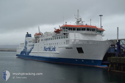
HAMNAVOE
Ro-Ro/Passenger Ship
Current Trip
| Trip Time | 1 h, 23 mins |
|---|---|
| Trip Distance | 24.87 nm |
| AVG Speed | 14.6 Knots |
| MAX Speed | 19.1 Knots |
| Draught | 4.5 m |
| AVG Wind | 12.2 knots |
| MAX Wind | 13 knots |
| MIN Temp | 10.7°C / 51.26°F |
| MAX Temp | 11.2°C / 52.16°F |
| Position Received | 1 m ago |
Current Position
| Longitude | -3.29501° |
|---|---|
| Latitude | 58.96351° |
| Status | Under way using engine |
| Speed | |
| Course | 355° |
| Area | North Sea |
| Station | T-AIS |
| Position Received | 1 m ago |
Info
Information
The current position of HAMNAVOE is in North Sea with coordinates 58.96351° / -3.29501° as reported on 2024-06-01 05:22 by AIS to our vessel tracker app. The vessel's current speed is 0 Knots and is currently inside the port of STROMNESS.
The vessel HAMNAVOE (IMO: 9246061, MMSI: 235449000) is a Ro-Ro/Passenger Ship that was built in 2002 ( 22 years old ). It's sailing under the flag of [GB] United Kingdom.
In this page you can find informations about the vessels current position, last detected port calls, and current voyage information. If the vessels is not in coverage by AIS you will find the latest position.
The current position of HAMNAVOE is detected by our AIS receivers and we are not responsible for the reliability of the data. The last position was recorded while the vessel was in Coverage by the Ais receivers of our vessel tracking app.
The current draught of HAMNAVOE as reported by AIS is 4.5 meters
Weather
| Temperature | 10.4°C / 50.72°F |
|---|---|
| Wind Speed | 12 knots |
| Direction | 287° WNW |
| Pressure | 1026.7 hPa |
| Humidity | 91.1 % |
| Cloud Coverage | 85 % |
Featured Company
Last Port Calls
| Port | Arrival | Departure | Time In Port |
|---|---|---|---|
| 2024-05-31 19:26 | |||
| 2024-05-31 17:04 | 2024-05-31 18:03 | 58 m | |
| 2024-05-31 13:32 | 2024-05-31 15:38 | 2 h | |
| 2024-05-31 11:24 | 2024-05-31 12:06 | 42 m | |
| 2024-05-31 09:05 | 2024-05-31 10:04 | 58 m | |
| 2024-05-31 06:50 | 2024-05-31 07:45 | 55 m | |
| 2024-05-30 19:21 | 2024-05-31 05:31 | 10 h | |
| 2024-05-30 17:03 | 2024-05-30 17:58 | 54 m | |
| 2024-05-30 13:34 | 2024-05-30 15:37 | 2 h | |
| 2024-05-30 11:25 | 2024-05-30 12:06 | 40 m |
Last Trips
| Origin | Departure | Destination | Arrival | Distance | |
|---|---|---|---|---|---|
| 2024-05-31 19:03 | 2024-05-31 20:26 | 24.87 nm | |||
| 2024-05-31 16:38 | 2024-05-31 18:04 | 24.93 nm | |||
| 2024-05-31 13:06 | 2024-05-31 14:32 | 24.73 nm | |||
| 2024-05-31 11:04 | 2024-05-31 12:24 | 24.69 nm | |||
| 2024-05-31 08:45 | 2024-05-31 10:05 | 24.67 nm | |||
| 2024-05-31 06:31 | 2024-05-31 07:50 | 24.68 nm | |||
| 2024-05-30 18:58 | 2024-05-30 20:21 | 24.21 nm | |||
| 2024-05-30 16:37 | 2024-05-30 18:03 | 24.86 nm | |||
| 2024-05-30 13:06 | 2024-05-30 14:34 | 24.82 nm | |||
| 2024-05-30 11:07 | 2024-05-30 12:25 | 24.48 nm |
Events
| Time | Event | Details | Position / Dest | Info |
|---|---|---|---|---|
| 2024-06-01 05:19 | Status Changed | Under way using engine Moored |
58.96351 / -3.29502
[GB] STROMNESS
|
Speed: Course: 355° |
| 2024-06-01 05:19 | ETA Changed | 2024/06/01 08:00 2024/06/01 08:15 |
58.96351 / -3.29502
[GB] STROMNESS
|
Speed: Course: 355° |
| 2024-05-31 19:40 | ETA Changed | 2024/06/01 08:15 2024/05/31 20:30 |
58.96351 / -3.29501
[GB] STROMNESS
|
Speed: Course: 355° |
| 2024-05-31 19:34 | Status Changed | Moored Under way using engine |
58.96351 / -3.29501
[GB] STROMNESS
|
Speed: Course: 355° |
| 2024-05-31 19:32 | STOP Moving |
58.96349 / -3.29501
[GB] STROMNESS
|
Speed: 0.2 kn Course: 355° |
|
| 2024-05-31 19:26 | PORT ARRIVAL |
|
58.95796 / -3.29588
[GB] STROMNESS
|
Speed: 7.3 kn Course: 2.8° |
| 2024-05-31 19:13 | Change Sea Area | United Kingdom part of the North Sea United Kingdom part of the North Atlantic Ocean |
58.94493 / -3.35188
North Sea
STROMNESS SCRABSTER
|
Speed: 17.4 kn Course: 77.1° |
| 2024-05-31 18:52 | ETA Changed | 2024/05/31 20:30 2024/05/31 18:15 |
58.86633 / -3.47362
STROMNESS SCRABSTER
|
Speed: 18.5 kn Course: 9.8° |
| 2024-05-31 18:03 | PORT DEPARTURE |
|
58.61452 / -3.53117
STROMNESS SCRABSTER
|
Speed: 7.2 kn Course: 38° |
| 2024-05-31 18:01 | START Moving |
58.60936 / -3.53884
[GB] SCRABSTER
|
Speed: 7 kn Course: 107° |