
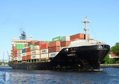
HARRISON
Container Ship
Current Trip
| Time Travelled | 25 mins |
|---|---|
| Remaining Time | 5 h, 13 mins |
| Distance Travelled | 3.65 nm |
| Remaining Distance | 79.75 nm |
| AVG Speed | 15.6 Knots |
| MAX Speed | 15.9 Knots |
| AVG Wind | 11 knots |
| MAX Wind | 12 knots |
| MIN Temp | 15.4°C / 59.72°F |
| MAX Temp | 16.2°C / 61.16°F |
| Draught | 9.3 m |
| Position Received | 2 m ago |
Current Position
| Longitude | 9.02346° |
|---|---|
| Latitude | 53.86029° |
| Status | Under way using engine |
| Speed | 16.3 Knots |
| Course | 246.7° |
| Area | Baltic Sea |
| Station | T-AIS |
| Position Received | 2 m ago |
Info
Information
The current position of HARRISON is in Baltic Sea with coordinates 53.86029° / 9.02346° as reported on 2024-06-04 13:50 by AIS to our vessel tracker app. The vessel's current speed is 16.3 Knots and is heading at the port of BREMERHAVEN. The estimated time of arrival as calculated by vessel tracking app is 2024-06-04 19:06 LT
The vessel HARRISON (IMO: 9220079, MMSI: 538001652) is a Container Ship that was built in 2002 ( 22 years old ). It's sailing under the flag of [MH] Marshall Is.
In this page you can find informations about the vessels current position, last detected port calls, and current voyage information. If the vessels is not in coverage by AIS you will find the latest position.
The current position of HARRISON is detected by our AIS receivers and we are not responsible for the reliability of the data. The last position was recorded while the vessel was in Coverage by the Ais receivers of our vessel tracking app.
The current draught of HARRISON as reported by AIS is 9.3 meters
Weather
| Temperature | 16.2°C / 61.16°F |
|---|---|
| Wind Speed | 11 knots |
| Direction | 197° SSW |
| Pressure | 1011.3 hPa |
| Humidity | 84.2 % |
| Cloud Coverage | 100 % |
Featured Company
Last Port Calls
| Port | Arrival | Departure | Time In Port |
|---|---|---|---|
| 2024-06-04 12:05 | 2024-06-04 13:28 | 1 h | |
| 2024-06-01 05:31 | 2024-06-02 10:14 | 1 d | |
| 2024-05-30 03:47 | 2024-05-30 13:52 | 10 h | |
| 2024-05-28 16:11 | 2024-05-29 00:55 | 8 h | |
| 2024-05-28 06:03 | 2024-05-28 06:05 | 2 m | |
| 2024-05-25 22:42 | 2024-05-27 16:05 | 1 d | |
| 2024-05-24 19:17 | 2024-05-25 13:37 | 18 h | |
| 2024-05-24 11:57 | 2024-05-24 13:14 | 1 h | |
| 2024-05-21 17:06 | 2024-05-22 16:38 | 23 h | |
| 2024-05-20 04:14 | 2024-05-20 21:14 | 17 h |
Most Visited Ports (Last year)
| Port | Arrivals | |
|---|---|---|
| 25 | ||
| 16 | ||
| 14 | ||
| 14 | ||
| 13 | ||
| 9 |
Last Trips
| Origin | Departure | Destination | Arrival | Distance | |
|---|---|---|---|---|---|
| 2024-06-02 12:14 | 2024-06-04 14:05 | 677.37 nm | |||
| 2024-05-30 15:52 | 2024-06-01 07:31 | 450.43 nm | |||
| 2024-05-29 02:55 | 2024-05-30 05:47 | 435.66 nm | |||
| 2024-05-28 08:05 | 2024-05-28 18:11 | 135.23 nm | |||
| 2024-05-27 18:05 | 2024-05-28 08:03 | 91.19 nm | |||
| 2024-05-25 15:37 | 2024-05-26 00:42 | 115.36 nm | |||
| 2024-05-24 15:14 | 2024-05-24 21:17 | 82.84 nm | |||
| 2024-05-22 18:38 | 2024-05-24 13:57 | 517.41 nm | |||
| 2024-05-20 23:14 | 2024-05-21 19:06 | 268.03 nm | |||
| 2024-05-18 20:04 | 2024-05-20 06:14 | 448.44 nm |
Events
| Time | Event | Details | Position / Dest | Info |
|---|---|---|---|---|
| 2024-06-04 13:29 | START Moving | 0.92 nm, South West of BRUNSBUETTEL |
53.89226 / 9.14121
DEBRV VIA DENOK
|
Speed: 3.1 kn Course: 224° |
| 2024-06-04 13:28 | PORT DEPARTURE |
|
53.89251 / 9.14170
DEBRV VIA DENOK
|
Speed: 2.1 kn Course: 230° |
| 2024-06-04 13:28 | Change Sea Area | German part of the North Sea German part of the Baltic Sea |
53.89274 / 9.14232
North Sea
DEBRV VIA DENOK
|
Speed: 2.1 kn Course: 233.1° |
| 2024-06-04 12:40 | STOP Moving |
53.89397 / 9.14458
[DE] BRUNSBUETTEL
|
Speed: 0.3 kn Course: 225° |
|
| 2024-06-04 12:22 | START Moving |
53.90139 / 9.15796
[DE] BRUNSBUETTEL
|
Speed: 3.6 kn Course: 222° |
|
| 2024-06-04 12:05 | STOP Moving |
53.90285 / 9.16017
[DE] BRUNSBUETTEL
|
Speed: 0.3 kn Course: 228° |
|
| 2024-06-04 12:05 | PORT ARRIVAL |
|
53.90286 / 9.16018
[DE] BRUNSBUETTEL
|
Speed: 0.7 kn Course: 227° |
| 2024-06-04 10:16 | Status Changed | Under way using engine Default |
54.05802 / 9.30887
DEBRV VIA DENOK
|
Speed: 6.5 kn Course: 195° |
| 2024-06-04 10:12 | Status Changed | Default Under way using engine |
54.06518 / 9.31169
DEBRV VIA DENOK
|
Speed: 6.7 kn Course: 196.4° |
| 2024-06-04 10:05 | Status Changed | Under way using engine Default |
54.07730 / 9.31765
DEBRV VIA DENOK
|
Speed: 6.7 kn Course: 198° |