
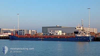
HAV GROUPER
General Cargo
Current Trip
| Time Travelled | 4 days |
|---|---|
| Remaining Time | 3 days |
| Distance Travelled | 907.45 nm |
| Remaining Distance | 694.38 nm |
| AVG Speed | 8.2 Knots |
| MAX Speed | 11.6 Knots |
| AVG Wind | 12.8 knots |
| MAX Wind | 20 knots |
| MIN Temp | 12.3°C / 54.14°F |
| MAX Temp | 22.2°C / 71.96°F |
| Draught | 4.6 m |
| Position Received | 1 m ago |
Current Position
| Longitude | -6.08899° |
|---|---|
| Latitude | 48.57157° |
| Status | Under way using engine |
| Speed | 8.9 Knots |
| Course | 204.8° |
| Area | Celtic Sea |
| Station | T-AIS |
| Position Received | 1 m ago |
Info
Information
The current position of HAV GROUPER is in Celtic Sea with coordinates 48.57157° / -6.08899° as reported on 2024-05-19 22:20 by AIS to our vessel tracker app. The vessel's current speed is 8.9 Knots and is heading at the port of SETUBAL. The estimated time of arrival as calculated by vessel tracking app is 2024-05-22 22:40 LT
The vessel HAV GROUPER (IMO: 9001837, MMSI: 304633000) is a General Cargo that was built in 1991 ( 33 years old ). It's sailing under the flag of [AG] Antigua Barbuda.
In this page you can find informations about the vessels current position, last detected port calls, and current voyage information. If the vessels is not in coverage by AIS you will find the latest position.
The current position of HAV GROUPER is detected by our AIS receivers and we are not responsible for the reliability of the data. The last position was recorded while the vessel was in Coverage by the Ais receivers of our vessel tracking app.
The current draught of HAV GROUPER as reported by AIS is 4.6 meters
Weather
| Temperature | 14.5°C / 58.1°F |
|---|---|
| Wind Speed | 9 knots |
| Direction | 33° NNE |
| Pressure | 1013.6 hPa |
| Humidity | 80.9 % |
| Cloud Coverage | --- |
Featured Company
Last Port Calls
| Port | Arrival | Departure | Time In Port |
|---|---|---|---|
| 2024-05-12 16:38 | 2024-05-15 15:03 | 2 d | |
| 2024-05-09 13:17 | 2024-05-10 13:36 | 1 d | |
| 2024-04-30 20:02 | 2024-05-01 12:55 | 16 h | |
| 2024-04-27 11:39 | 2024-04-29 14:47 | 2 d | |
| 2024-04-23 23:25 | 2024-04-24 11:13 | 11 h | |
| 2024-04-23 19:15 | 2024-04-23 19:57 | 41 m | |
| 2024-04-05 16:22 | 2024-04-23 18:56 | 18 d | |
| 2024-04-02 20:59 | 2024-04-05 15:40 | 2 d | |
| 2024-04-02 19:56 | 2024-04-02 20:15 | 18 m | |
| 2024-04-02 18:54 | 2024-04-02 19:35 | 41 m |
Most Visited Ports (Last year)
| Port | Arrivals | |
|---|---|---|
| 6 | ||
| 5 | ||
| 4 | ||
| 4 | ||
| 4 | ||
| 2 |
Last Trips
| Origin | Departure | Destination | Arrival | Distance | |
|---|---|---|---|---|---|
| 2024-05-10 15:36 | 2024-05-12 18:38 | 151.74 nm | |||
| 2024-05-01 14:55 | 2024-05-09 15:17 | 1030.24 nm | |||
| 2024-04-29 16:47 | 2024-04-30 22:02 | 124.49 nm | |||
| 2024-04-23 20:57 | 2024-04-27 13:39 | 653.44 nm | |||
| 2024-04-23 20:57 | 2024-04-24 00:25 | 26.84 nm | |||
| 2024-04-23 19:56 | 2024-04-23 20:15 | 1.95 nm | |||
| 2024-04-05 16:40 | 2024-04-05 17:22 | 4.68 nm | |||
| 2024-04-02 21:15 | 2024-04-02 21:59 | 4.17 nm | |||
| 2024-04-02 20:35 | 2024-04-02 20:56 | 1.95 nm | |||
| 2024-03-27 20:40 | 2024-04-02 19:54 | 1043.89 nm |
Events
| Time | Event | Details | Position / Dest | Info |
|---|---|---|---|---|
| 2024-05-19 20:43 | Status Changed | Under way using engine Default |
48.79316 / -5.91237
SETUBAL
|
Speed: 9.6 kn Course: 208° |
| 2024-05-19 20:37 | Status Changed | Default Under way using engine |
48.80888 / -5.89964
SETUBAL
|
Speed: 9.7 kn Course: 207.5° |
| 2024-05-19 16:41 | ETA Changed | 2024/05/23 12:00 2024/05/23 17:00 |
49.16038 / -5.10307
SETUBAL
|
Speed: 9.2 kn Course: 239.5° |
| 2024-05-19 16:34 | Status Changed | Under way using engine Default |
49.16855 / -5.08144
SETUBAL
|
Speed: 9 kn Course: 240° |
| 2024-05-19 16:30 | Status Changed | Default Under way using engine |
49.17300 / -5.06978
SETUBAL
|
Speed: 8.9 kn Course: 238.9° |
| 2024-05-19 16:16 | Detected in Sea | French part of the Celtic Sea |
49.19102 / -5.02358
Celtic Sea
SETUBAL
|
Speed: 8.8 kn Course: 240.2° |
| 2024-05-19 12:29 | Detected in Sea | French part of the English Channel |
49.46977 / -4.33490
English Channel
SETUBAL
|
Speed: 8.5 kn Course: 237.6° |
| 2024-05-19 12:09 | Detected in Sea | United Kingdom part of the English Channel |
49.49578 / -4.27266
English Channel
SETUBAL
|
Speed: 8.8 kn Course: 239.2° |
| 2024-05-19 11:53 | Detected in Sea | French part of the English Channel |
49.51689 / -4.22194
English Channel
SETUBAL
|
Speed: 8.9 kn Course: 237.5° |
| 2024-05-19 07:13 | Status Changed | Under way using engine Default |
49.89583 / -3.22401
SETUBAL
|
Speed: 9 kn Course: 239° |