
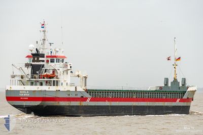
HEKLA
General Cargo
Current Trip
| Time Travelled | 2 days |
|---|---|
| Remaining Time | 33 mins |
| Distance Travelled | 519.49 nm |
| Remaining Distance | 5.98 nm |
| AVG Speed | 7.6 Knots |
| MAX Speed | 11.6 Knots |
| AVG Wind | 13.7 knots |
| MAX Wind | 21.3 knots |
| MIN Temp | 11.6°C / 52.88°F |
| MAX Temp | 15.8°C / 60.44°F |
| Draught | 5.5 m |
| Position Received | Now |
Current Position
| Longitude | 8.49148° |
|---|---|
| Latitude | 53.43048° |
| Status | Under way using engine |
| Speed | 7.2 Knots |
| Course | 175.9° |
| Area | North Sea |
| Station | T-AIS |
| Position Received | Now |
Info
Information
The current position of HEKLA is in North Sea with coordinates 53.43048° / 8.49148° as reported on 2024-06-16 03:21 by AIS to our vessel tracker app. The vessel's current speed is 7.2 Knots and is heading at the port of BRAKE. The estimated time of arrival as calculated by vessel tracking app is 2024-06-16 03:55 LT
The vessel HEKLA (IMO: 9356505, MMSI: 245281000) is a General Cargo that was built in 2008 ( 16 years old ). It's sailing under the flag of [NL] Netherlands.
In this page you can find informations about the vessels current position, last detected port calls, and current voyage information. If the vessels is not in coverage by AIS you will find the latest position.
The current position of HEKLA is detected by our AIS receivers and we are not responsible for the reliability of the data. The last position was recorded while the vessel was in Coverage by the Ais receivers of our vessel tracking app.
The current draught of HEKLA as reported by AIS is 5.5 meters
Weather
| Temperature | 12.3°C / 54.14°F |
|---|---|
| Wind Speed | 9 knots |
| Direction | 180° S |
| Pressure | 1005.8 hPa |
| Humidity | 86.5 % |
| Cloud Coverage | 100 % |
Featured Company
Last Port Calls
| Port | Arrival | Departure | Time In Port |
|---|---|---|---|
| 2024-06-13 04:15 | 2024-06-13 13:11 | 8 h | |
| 2024-05-29 16:00 | 2024-05-31 17:29 | 2 d | |
| 2024-05-27 11:53 | 2024-05-29 15:44 | 2 d | |
| 2024-05-20 04:57 | 2024-05-23 17:58 | 3 d | |
| 2024-05-17 14:58 | 2024-05-18 14:41 | 23 h | |
| 2024-05-12 01:28 | 2024-05-13 11:48 | 1 d | |
| 2024-05-08 16:15 | 2024-05-10 13:25 | 1 d | |
| 2024-05-02 07:00 | 2024-05-03 19:22 | 1 d | |
| 2024-04-25 00:14 | 2024-04-26 14:10 | 1 d | |
| 2024-04-19 02:35 | 2024-04-21 15:05 | 2 d |
Most Visited Ports (Last year)
| Port | Arrivals | |
|---|---|---|
| 8 | ||
| 5 | ||
| 3 | ||
| 3 | ||
| 3 | ||
| 3 |
Last Trips
| Origin | Departure | Destination | Arrival | Distance | |
|---|---|---|---|---|---|
| 2024-05-31 19:29 | 2024-06-13 06:15 | 1712.38 nm | |||
| 2024-05-29 17:44 | 2024-05-29 18:00 | 3.24 nm | |||
| 2024-05-23 19:58 | 2024-05-27 13:53 | 855.86 nm | |||
| 2024-05-18 16:41 | 2024-05-20 06:57 | 384.70 nm | |||
| 2024-05-13 13:48 | 2024-05-17 16:58 | 662.06 nm | |||
| 2024-05-10 15:25 | 2024-05-12 03:28 | 320.04 nm | |||
| 2024-05-03 20:22 | 2024-05-08 18:15 | 972.71 nm | |||
| 2024-04-26 15:10 | 2024-05-02 08:00 | 1043.65 nm | |||
| 2024-04-21 17:05 | 2024-04-25 01:14 | 765.35 nm | |||
| 2024-04-19 01:12 | 2024-04-19 04:35 | 31.81 nm |
Events
| Time | Event | Details | Position / Dest | Info |
|---|---|---|---|---|
| 2024-06-15 22:12 | Status Changed | Under way using engine Default |
54.00465 / 7.97569
BRAKE
|
Speed: 9.8 kn Course: 268° |
| 2024-06-15 21:42 | Status Changed | Default Under way using engine |
54.00834 / 8.11500
BRAKE
|
Speed: 10.3 kn Course: 271.4° |
| 2024-06-15 21:33 | Status Changed | Under way using engine Default |
54.00868 / 8.15714
BRAKE
|
Speed: 10.3 kn Course: 274° |
| 2024-06-15 21:25 | Status Changed | Default Under way using engine |
54.00806 / 8.19868
BRAKE
|
Speed: 10.5 kn Course: 279.3° |
| 2024-06-15 17:14 | START Moving | 0.88 nm, South West of BRUNSBUETTEL |
53.89106 / 9.14574
BRAKE
|
Speed: 3.7 kn Course: 215° |
| 2024-06-15 16:55 | STOP Moving | 0.76 nm, South West of BRUNSBUETTEL |
53.89255 / 9.14790
BRAKE
|
Speed: 0.3 kn Course: 219° |
| 2024-06-15 16:52 | Change Sea Area | German part of the North Sea German part of the Baltic Sea |
53.89307 / 9.14854
North Sea
BRAKE
|
Speed: 1.7 kn Course: 216.1° |
| 2024-06-15 14:50 | Status Changed | Under way using engine Default |
54.07679 / 9.31708
BRAKE
|
Speed: 6.4 kn Course: 199° |
| 2024-06-15 14:28 | Status Changed | Default Under way using engine |
54.11790 / 9.32794
BRAKE
|
Speed: 6.9 kn Course: 190.4° |
| 2024-06-15 13:00 | START Moving | 6.69 nm, North East of FISCHERHUTTE |
54.19754 / 9.54808
BRAKE
|
Speed: 3.6 kn Course: 235° |