
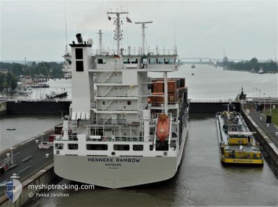
HENNEKE RAMBOW
Container Ship
Current Trip
| Time Travelled | 1 day |
|---|---|
| Remaining Time | --- |
| Distance Travelled | 443.75 nm |
| Remaining Distance | --- |
| AVG Speed | 15 Knots |
| MAX Speed | 16.2 Knots |
| AVG Wind | 14.1 knots |
| MAX Wind | 21 knots |
| MIN Temp | 16.8°C / 62.24°F |
| MAX Temp | 21.5°C / 70.7°F |
| Draught | 7.4 m |
| Position Received | 7 h, 35 m ago |
Current Position
| Longitude | -9.78577° |
|---|---|
| Latitude | 42.12259° |
| Status | Under way using engine |
| Speed | 9.1 Knots |
| Course | 0.8° |
| Area | North Atlantic Ocean |
| Station | T-AIS |
| Position Received | 7 h, 35 m ago |
Info
Information
The current position of HENNEKE RAMBOW is in North Atlantic Ocean with coordinates 42.12259° / -9.78577° as reported on 2024-06-06 20:36 by AIS to our vessel tracker app. The vessel's current speed is 9.1 Knots
The vessel HENNEKE RAMBOW (IMO: 9354430, MMSI: 218044000) is a Container Ship that was built in 2007 ( 17 years old ). It's sailing under the flag of [DE] Germany.
In this page you can find informations about the vessels current position, last detected port calls, and current voyage information. If the vessels is not in coverage by AIS you will find the latest position.
The current position of HENNEKE RAMBOW is detected by our AIS receivers and we are not responsible for the reliability of the data. The last position was recorded while the vessel was in Coverage by the Ais receivers of our vessel tracking app.
The current draught of HENNEKE RAMBOW as reported by AIS is 7.4 meters
Weather
| Temperature | 15.1°C / 59.18°F |
|---|---|
| Wind Speed | 31 knots |
| Direction | 43° NE |
| Pressure | 1014.9 hPa |
| Humidity | 85.7 % |
| Cloud Coverage | 100 % |
Featured Company
Last Port Calls
| Port | Arrival | Departure | Time In Port |
|---|---|---|---|
| 2024-06-04 16:52 | 2024-06-05 14:51 | 21 h | |
| 2024-06-04 05:08 | 2024-06-04 13:36 | 8 h | |
| 2024-06-02 19:16 | 2024-06-03 13:29 | 18 h | |
| 2024-06-01 21:58 | 2024-06-02 03:57 | 5 h | |
| 2024-05-30 20:34 | 2024-05-31 12:18 | 15 h | |
| 2024-05-30 04:52 | 2024-05-30 16:25 | 11 h | |
| 2024-05-24 01:02 | 2024-05-24 14:55 | 13 h | |
| 2024-05-24 00:28 | |||
| 2024-05-21 12:55 | 2024-05-22 13:19 | 1 d | |
| 2024-05-19 16:42 | 2024-05-20 08:58 | 16 h |
Most Visited Ports (Last year)
| Port | Arrivals | |
|---|---|---|
| 27 | ||
| 19 | ||
| 17 | ||
| 13 | ||
| 11 | ||
| 9 |
Last Trips
| Origin | Departure | Destination | Arrival | Distance | |
|---|---|---|---|---|---|
| 2024-06-04 15:36 | 2024-06-04 18:52 | 47.49 nm | |||
| 2024-06-03 15:29 | 2024-06-04 07:08 | 94.97 nm | |||
| 2024-06-02 04:57 | 2024-06-02 21:16 | 193.61 nm | |||
| 2024-05-31 13:18 | 2024-06-01 22:58 | 552.75 nm | |||
| 2024-05-30 17:25 | 2024-05-30 21:34 | 53.45 nm | |||
| 2024-05-24 16:55 | 2024-05-30 05:52 | 1832.72 nm | |||
| 2024-05-22 15:19 | 2024-05-24 03:02 | 330.61 nm | |||
| 2024-05-22 15:19 | 2024-05-24 02:28 | 330.43 nm | |||
| 2024-05-20 09:58 | 2024-05-21 14:55 | 418.65 nm | |||
| 2024-05-15 14:27 | 2024-05-19 17:42 | 1277.91 nm |
Events
| Time | Event | Details | Position / Dest | Info |
|---|---|---|---|---|
| 2024-06-06 20:36 | OUT of Coverage |
42.12259 / -9.78577
North Atlantic Ocean
ESFRO
|
Speed: 9.1 kn Course: 0.8° |
|
| 2024-06-06 18:31 | Change Sea Area | Spanish part of the North Atlantic Ocean Portuguese part of the North Atlantic Ocean |
41.78487 / -9.78617
North Atlantic Ocean
ESFRO
|
Speed: 9.9 kn Course: 359.7° |
| 2024-06-06 18:30 | ETA Changed | 2024/06/07 13:00 2024/06/07 07:00 |
41.78032 / -9.78606
ESFRO
|
Speed: 9.8 kn Course: 0.1° |
| 2024-06-06 15:47 | IN Coverage |
41.32889 / -9.78531
North Atlantic Ocean
ESFRO
|
Speed: 15.9 kn Course: 0.1° |
|
| 2024-06-06 13:50 | OUT of Coverage |
40.81058 / -9.79688
North Atlantic Ocean
ESFRO
|
Speed: 16 kn Course: 0.8° |
|
| 2024-06-06 12:15 | IN Coverage |
40.39241 / -9.80053
North Atlantic Ocean
ESFRO
|
Speed: 15.7 kn Course: 2° |
|
| 2024-06-06 11:02 | OUT of Coverage |
40.06447 / -9.81075
North Atlantic Ocean
ESFRO
|
Speed: 15.6 kn Course: 2.7° |
|
| 2024-06-05 16:47 | Change Sea Area | Portuguese part of the North Atlantic Ocean Spanish part of the North Atlantic Ocean |
36.95551 / -7.36859
North Atlantic Ocean
ESFRO
|
Speed: 15.8 kn Course: 258.4° |
| 2024-06-05 14:51 | PORT DEPARTURE |
|
37.12234 / -6.83529
ESFRO
|
Speed: 7.4 kn Course: 159° |
| 2024-06-05 14:51 | Status Changed | Under way using engine Moored |
37.12389 / -6.83611
[ES] HUELVA
|
Speed: 7.4 kn Course: 158° |