
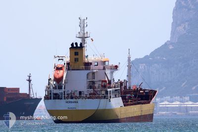
HERBANIA
Oil/Chemical Tanker
Current Trip
| Time Travelled | 9 h, 23 mins |
|---|---|
| Remaining Time | 22 h, 50 mins |
| Distance Travelled | 72.36 nm |
| Remaining Distance | 205.08 nm |
| AVG Speed | 9.2 Knots |
| MAX Speed | 11.8 Knots |
| AVG Wind | 11.1 knots |
| MAX Wind | 15.8 knots |
| MIN Temp | 16.7°C / 62.06°F |
| MAX Temp | 18.3°C / 64.94°F |
| Draught | 7.1 m |
| Position Received | Now |
Current Position
| Longitude | -9.80739° |
|---|---|
| Latitude | 38.44588° |
| Status | Under way using engine |
| Speed | 8.5 Knots |
| Course | 334.1° |
| Area | North Atlantic Ocean |
| Station | T-AIS |
| Position Received | Now |
Info
Information
The current position of HERBANIA is in North Atlantic Ocean with coordinates 38.44588° / -9.80739° as reported on 2024-06-01 04:28 by AIS to our vessel tracker app. The vessel's current speed is 8.5 Knots and is heading at the port of VIANA DO CASTELO. The estimated time of arrival as calculated by vessel tracking app is 2024-06-02 03:18 LT
The vessel HERBANIA (IMO: 9674828, MMSI: 255834000) is a Oil/Chemical Tanker that was built in 2013 ( 11 years old ). It's sailing under the flag of [PT] Portugal.
In this page you can find informations about the vessels current position, last detected port calls, and current voyage information. If the vessels is not in coverage by AIS you will find the latest position.
The current position of HERBANIA is detected by our AIS receivers and we are not responsible for the reliability of the data. The last position was recorded while the vessel was in Coverage by the Ais receivers of our vessel tracking app.
The current draught of HERBANIA as reported by AIS is 7.1 meters
Weather
| Temperature | 17.3°C / 63.14°F |
|---|---|
| Wind Speed | 13 knots |
| Direction | 351° N |
| Pressure | 1008.9 hPa |
| Humidity | 89.2 % |
| Cloud Coverage | 2 % |
Featured Company
Last Port Calls
| Port | Arrival | Departure | Time In Port |
|---|---|---|---|
| 2024-05-30 02:23 | 2024-05-31 19:05 | 1 d | |
| 2024-05-27 05:09 | 2024-05-28 04:56 | 23 h | |
| 2024-05-23 15:51 | 2024-05-26 02:57 | 2 d | |
| 2024-05-19 15:02 | 2024-05-20 12:31 | 21 h | |
| 2024-05-15 18:52 | 2024-05-17 08:03 | 1 d | |
| 2024-05-11 09:32 | 2024-05-13 18:34 | 2 d | |
| 2024-05-08 00:30 | 2024-05-09 21:51 | 1 d | |
| 2024-05-05 09:21 | 2024-05-06 02:04 | 16 h | |
| 2024-05-03 12:16 | 2024-05-03 18:53 | 6 h | |
| 2024-04-29 20:24 | 2024-04-30 11:53 | 15 h |
Most Visited Ports (Last year)
| Port | Arrivals | |
|---|---|---|
| 19 | ||
| 8 | ||
| 8 | ||
| 7 | ||
| 5 | ||
| 4 |
Last Trips
| Origin | Departure | Destination | Arrival | Distance | |
|---|---|---|---|---|---|
| 2024-05-28 06:56 | 2024-05-30 03:23 | 303.24 nm | |||
| 2024-05-26 03:57 | 2024-05-27 07:09 | 217.20 nm | |||
| 2024-05-20 14:31 | 2024-05-23 16:51 | 688.41 nm | |||
| 2024-05-17 09:03 | 2024-05-19 17:02 | 679.34 nm | |||
| 2024-05-13 19:34 | 2024-05-15 19:52 | 334.62 nm | |||
| 2024-05-09 23:51 | 2024-05-11 10:32 | 408.14 nm | |||
| 2024-05-06 04:04 | 2024-05-08 02:30 | 502.77 nm | |||
| 2024-05-03 20:53 | 2024-05-05 11:21 | 29.21 nm | |||
| 2024-04-30 13:53 | 2024-05-03 14:16 | 820.51 nm | |||
| 2024-04-28 11:11 | 2024-04-29 22:24 | 350.06 nm |
Events
| Time | Event | Details | Position / Dest | Info |
|---|---|---|---|---|
| 2024-06-01 00:04 | ETA Changed | 2025/05/30 05:00 2024/05/30 05:00 |
38.02023 / -9.11227
VIANA DO CASTELO
|
Speed: 11.3 kn Course: 303.5° |
| 2024-05-31 22:48 | START Moving | 1.61 nm, South of SINES |
37.91722 / -8.87110
VIANA DO CASTELO
|
Speed: 3.1 kn Course: 292° |
| 2024-05-31 22:46 | Destination Changed | VIANA DO CASTELO SINES |
37.91706 / -8.86928
VIANA DO CASTELO
|
Speed: 1.5 kn Course: 272° |
| 2024-05-31 22:40 | Status Changed | Under way using engine At anchor |
37.91692 / -8.86733
SINES
|
Speed: 0.3 kn Course: 249° |
| 2024-05-31 21:38 | STOP Moving | 1.62 nm, South of SINES |
37.91689 / -8.86704
SINES
|
Speed: 0.1 kn Course: 255° |
| 2024-05-31 21:26 | Status Changed | At anchor Under way using engine |
37.91681 / -8.86787
SINES
|
Speed: 0.8 kn Course: 305° |
| 2024-05-31 20:37 | START Moving | 7.09 nm, South West of SINES |
37.84954 / -8.95651
SINES
|
Speed: 3.3 kn Course: 288° |
| 2024-05-31 20:31 | STOP Moving | 6.99 nm, South West of SINES |
37.85058 / -8.95462
SINES
|
Speed: 0.3 kn Course: 166° |
| 2024-05-31 20:22 | START Moving | 7.21 nm, South West of SINES |
37.84793 / -8.95790
SINES
|
Speed: 3.2 kn Course: 267° |
| 2024-05-31 20:13 | STOP Moving | 7.2 nm, South West of SINES |
37.85065 / -8.96211
SINES
|
Speed: 0.3 kn Course: 343° |