
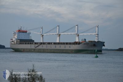
HERBERT
Cargo
Current Trip
| Time Travelled | 13 days |
|---|---|
| Remaining Time | 2 days |
| Distance Travelled | 2949.01 nm |
| Remaining Distance | 277.76 nm |
| AVG Speed | 9.9 Knots |
| MAX Speed | 15.1 Knots |
| AVG Wind | 12.8 knots |
| MAX Wind | 28 knots |
| MIN Temp | 4.7°C / 40.46°F |
| MAX Temp | 19.5°C / 67.1°F |
| Draught | 7.4 m |
| Position Received | 21 h, 45 m ago |
Current Position
| Longitude | 0.40587° |
|---|---|
| Latitude | 36.78318° |
| Status | Under way using engine |
| Speed | 5.1 Knots |
| Course | 75° |
| Area | Mediterranean Sea - Western Basin |
| Station | T-AIS |
| Position Received | 21 h, 45 m ago |
Info
Information
The current position of HERBERT is in Mediterranean Sea - Western Basin with coordinates 36.78318° / 0.40587° as reported on 2024-05-18 20:14 by AIS to our vessel tracker app. The vessel's current speed is 5.1 Knots and is heading at the port of ANNABA. The estimated time of arrival as calculated by vessel tracking app is 2024-05-21 21:34 LT
The vessel HERBERT (IMO: 9931551, MMSI: 636020696) is a Cargo It's sailing under the flag of [LR] Liberia.
In this page you can find informations about the vessels current position, last detected port calls, and current voyage information. If the vessels is not in coverage by AIS you will find the latest position.
The current position of HERBERT is detected by our AIS receivers and we are not responsible for the reliability of the data. The last position was recorded while the vessel was in Coverage by the Ais receivers of our vessel tracking app.
The current draught of HERBERT as reported by AIS is 7.4 meters
Weather
| Temperature | 19.2°C / 66.56°F |
|---|---|
| Wind Speed | 3 knots |
| Direction | 333° NNW |
| Pressure | 1009.3 hPa |
| Humidity | 68.2 % |
| Cloud Coverage | 58 % |
Featured Company
Most Visited Ports (Last year)
| Port | Arrivals | |
|---|---|---|
| 2 | ||
| 2 | ||
| 2 | ||
| 2 | ||
| 1 | ||
| 1 |
Events
| Time | Event | Details | Position / Dest | Info |
|---|---|---|---|---|
| 2024-05-18 20:20 | Status Changed | Default Under way using engine |
36.78507 / .41691
DZ AAE
|
Speed: 5.1 kn Course: 75° |
| 2024-05-18 20:14 | OUT of Coverage |
36.78318 / .40587
Mediterranean Sea - Western Basin
DZ AAE
|
Speed: 5.1 kn Course: 75° |
|
| 2024-05-18 20:09 | Status Changed | Under way using engine Default |
36.78160 / .39785
DZ AAE
|
Speed: 5.1 kn Course: 74° |
| 2024-05-18 19:59 | IN Coverage |
36.78196 / .39959
Mediterranean Sea - Western Basin
DZ AAE
|
Speed: 5.1 kn Course: 75.5° |
|
| 2024-05-18 17:00 | Status Changed | Default Under way using engine |
36.71503 / .06826
DZ AAE
|
Speed: 5.1 kn Course: 81.4° |
| 2024-05-18 16:53 | Status Changed | Under way using engine Default |
36.71326 / .05569
DZ AAE
|
Speed: 5.1 kn Course: 82° |
| 2024-05-18 16:53 | OUT of Coverage |
36.71326 / .05569
Mediterranean Sea - Western Basin
DZ AAE
|
Speed: 5.1 kn Course: 81.4° |
|
| 2024-05-18 16:49 | Status Changed | Default Under way using engine |
36.71229 / .04750
DZ AAE
|
Speed: 5.1 kn Course: 82.2° |
| 2024-05-18 16:43 | Status Changed | Under way using engine Default |
36.71117 / .03750
DZ AAE
|
Speed: 5.1 kn Course: 83° |
| 2024-05-18 16:41 | Status Changed | Default Under way using engine |
36.71075 / .03339
DZ AAE
|
Speed: 5.2 kn Course: 82.7° |