
HERMANOS MALONDA
Fishing
Current Trip
CULLERA
| Time Travelled | 7 h, 23 mins |
|---|---|
| Remaining Time | --- |
| Distance Travelled | 21.61 nm |
| Remaining Distance | --- |
| AVG Speed | 4.5 Knots |
| MAX Speed | 8.9 Knots |
| AVG Wind | 3.1 knots |
| MAX Wind | 5.3 knots |
| MIN Temp | 16.5°C / 61.7°F |
| MAX Temp | 19.7°C / 67.46°F |
| Draught | 0 m |
| Position Received | 53 m ago |
Current Position
| Longitude | 0.03719° |
|---|---|
| Latitude | 38.99875° |
| Status | Engaged in Fishing |
| Speed | 3.4 Knots |
| Course | 329.3° |
| Area | Balearic Sea |
| Station | T-AIS |
| Position Received | 53 m ago |
Info
Information
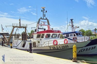
The current position of HERMANOS MALONDA is in Balearic Sea with coordinates 38.99875° / 0.03719° as reported on 2024-06-03 09:30 by AIS to our vessel tracker app. The vessel's current speed is 3.4 Knots
The vessel HERMANOS MALONDA (MMSI: 224008250) is a Fishing It's sailing under the flag of [ES] Spain.
In this page you can find informations about the vessels current position, last detected port calls, and current voyage information. If the vessels is not in coverage by AIS you will find the latest position.
The current position of HERMANOS MALONDA is detected by our AIS receivers and we are not responsible for the reliability of the data. The last position was recorded while the vessel was in Coverage by the Ais receivers of our vessel tracking app.
Weather
| Temperature | 19.6°C / 67.28°F |
|---|---|
| Wind Speed | 5 knots |
| Direction | 100° E |
| Pressure | 1018.3 hPa |
| Humidity | 66.4 % |
| Cloud Coverage | --- |
Featured Company
Last Port Calls
| Port | Arrival | Departure | Time In Port |
|---|---|---|---|
| 2024-05-30 14:54 | 2024-06-03 03:00 | 3 d | |
| 2024-05-28 14:45 | 2024-05-29 02:58 | 12 h | |
| 2024-05-21 02:59 | |||
| 2024-05-10 03:00 | |||
| 2024-05-07 02:59 | |||
| 2024-05-06 02:59 | |||
| 2024-05-06 02:59 | |||
| 2024-05-03 02:59 | |||
| 2024-04-29 03:01 | |||
| 2024-04-17 02:59 |
Events
| Time | Event | Details | Position / Dest | Info |
|---|---|---|---|---|
| 2024-06-03 08:42 | START Moving | 8.08 nm, North of DENIA |
38.96726 / .05094
CULLERA
|
Speed: 8.9 kn Course: 86.9° |
| 2024-06-03 08:33 | STOP Moving | 8.06 nm, North West of DENIA |
38.96623 / .04870
CULLERA
|
Speed: Course: 511° |
| 2024-06-03 08:30 | START Moving | 8.12 nm, North West of DENIA |
38.96701 / .04761
CULLERA
|
Speed: 5.6 kn Course: 184° |
| 2024-06-03 08:28 | STOP Moving | 8.23 nm, North West of DENIA |
38.96816 / .04558
CULLERA
|
Speed: 0.2 kn Course: 511° |
| 2024-06-03 04:57 | IN Coverage |
39.11216 / -.08288
Balearic Sea
|
Speed: 3.2 kn Course: 163.5° |
|
| 2024-06-03 03:08 | OUT of Coverage |
39.15661 / -.21260
Balearic Sea
|
Speed: 9 kn Course: 75.6° |
|
| 2024-06-03 03:00 | PORT DEPARTURE |
|
39.15096 / -.23545
CULLERA
|
Speed: 5.4 kn Course: 102.5° |
| 2024-06-03 02:51 | IN Coverage |
39.15463 / -.24863
Balearic Sea
[ES] CULLERA
|
Speed: 4.3 kn Course: 127° |
|
| 2024-05-30 15:00 | OUT of Coverage |
39.16061 / -.25504
Balearic Sea
[ES] CULLERA
|
Speed: Course: 0° |
|
| 2024-05-30 14:54 | STOP Moving |
39.16062 / -.25503
[ES] CULLERA
|
Speed: Course: 511° |