
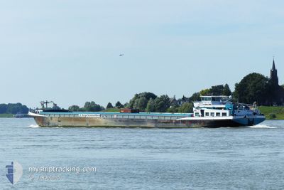
HERMINA
Cargo
Current Trip
| Time Travelled | 16 h, 25 mins |
|---|---|
| Remaining Time | 6 h, 29 mins |
| Distance Travelled | 95.66 nm |
| Remaining Distance | 39.85 nm |
| AVG Speed | 6 Knots |
| MAX Speed | 8.5 Knots |
| AVG Wind | 5.3 knots |
| MAX Wind | 11.4 knots |
| MIN Temp | 12°C / 53.6°F |
| MAX Temp | 21.6°C / 70.88°F |
| Draught | 4.2 m |
| Position Received | Now |
Current Position
| Longitude | 6.04436° |
|---|---|
| Latitude | 51.56075° |
| Status | Under way using engine |
| Speed | 5.9 Knots |
| Course | 140.9° |
| Area | North Sea |
| Station | T-AIS |
| Position Received | Now |
Info
Information
The current position of HERMINA is in North Sea with coordinates 51.56075° / 6.04436° as reported on 2024-05-18 15:04 by AIS to our vessel tracker app. The vessel's current speed is 5.9 Knots and is heading at the port of BARGE TERMINAL BORN. The estimated time of arrival as calculated by vessel tracking app is 2024-05-18 21:33 LT
The vessel HERMINA (MMSI: 244750786) is a Cargo It's sailing under the flag of [NL] Netherlands.
In this page you can find informations about the vessels current position, last detected port calls, and current voyage information. If the vessels is not in coverage by AIS you will find the latest position.
The current position of HERMINA is detected by our AIS receivers and we are not responsible for the reliability of the data. The last position was recorded while the vessel was in Coverage by the Ais receivers of our vessel tracking app.
The current draught of HERMINA as reported by AIS is 4.2 meters
Weather
| Temperature | 20.9°C / 69.62°F |
|---|---|
| Wind Speed | 9 knots |
| Direction | 22° NNE |
| Pressure | 1009.3 hPa |
| Humidity | 58.3 % |
| Cloud Coverage | 57 % |
Featured Company
Last Port Calls
| Port | Arrival | Departure | Time In Port |
|---|---|---|---|
| 2024-05-17 16:44 | 2024-05-17 22:39 | 5 h | |
| 2024-05-17 09:40 | 2024-05-17 13:26 | 3 h | |
| 2024-05-17 06:49 | 2024-05-17 07:26 | 36 m | |
| 2024-05-16 19:33 | 2024-05-17 04:59 | 9 h | |
| 2024-05-16 10:38 | 2024-05-16 11:46 | 1 h | |
| 2024-05-15 19:28 | 2024-05-16 01:20 | 5 h | |
| 2024-05-15 07:09 | 2024-05-15 08:22 | 1 h | |
| 2024-05-14 14:28 | 2024-05-14 21:59 | 7 h | |
| 2024-05-13 11:49 | 2024-05-14 10:04 | 22 h | |
| 2024-05-12 09:34 | 2024-05-12 15:38 | 6 h |
Most Visited Ports (Last year)
| Port | Arrivals | |
|---|---|---|
| 189 | ||
| 134 | ||
| 96 | ||
| 84 | ||
| 37 | ||
| 19 |
Last Trips
| Origin | Departure | Destination | Arrival | Distance | |
|---|---|---|---|---|---|
| 2024-05-17 15:26 | 2024-05-17 18:44 | 30.48 nm | |||
| 2024-05-17 09:26 | 2024-05-17 11:40 | 20.16 nm | |||
| 2024-05-17 06:59 | 2024-05-17 08:49 | 15.17 nm | |||
| 2024-05-16 13:46 | 2024-05-16 21:33 | 75.08 nm | |||
| 2024-05-16 03:20 | 2024-05-16 12:38 | 56.96 nm | |||
| 2024-05-15 10:22 | 2024-05-15 21:28 | 54.38 nm | |||
| 2024-05-14 23:59 | 2024-05-15 09:09 | 53.06 nm | |||
| 2024-05-14 12:04 | 2024-05-14 16:28 | 30.47 nm | |||
| 2024-05-12 17:38 | 2024-05-13 13:49 | 132.31 nm | |||
| 2024-05-11 14:26 | 2024-05-12 11:34 | 111.95 nm |
Events
| Time | Event | Details | Position / Dest | Info |
|---|---|---|---|---|
| 2024-05-18 14:07 | START Moving | 2.04 nm, South East of BOXMEER |
51.63980 / 5.98557
HOLTUM GULYCKGELDERH
|
Speed: 3.1 kn Course: 126.8° |
| 2024-05-18 13:48 | STOP Moving | 1.89 nm, South East of BOXMEER |
51.64133 / 5.98153
HOLTUM GULYCKGELDERH
|
Speed: Course: 511° |
| 2024-05-18 11:14 | Destination Changed | HOLTUM GULYCKGELDERH VOORHAVEN SLUIS WEUR |
51.84405 / 5.81457
HOLTUM GULYCKGELDERH
|
Speed: 6.3 kn Course: 206.6° |
| 2024-05-18 11:14 | ETA Changed | 2024/05/20 06:52 2024/05/18 13:54 |
51.84405 / 5.81457
HOLTUM GULYCKGELDERH
|
Speed: 6.3 kn Course: 206.6° |
| 2024-05-18 11:08 | START Moving | 0.33 nm, North of NIJMEGEN |
51.85258 / 5.82199
VOORHAVEN SLUIS WEUR
|
Speed: 3.2 kn Course: 208.3° |
| 2024-05-18 10:54 | STOP Moving | 0.42 nm, North of NIJMEGEN |
51.85420 / 5.82332
VOORHAVEN SLUIS WEUR
|
Speed: 0.3 kn Course: 511° |
| 2024-05-17 22:39 | PORT DEPARTURE |
|
51.94751 / 4.07994
VOORHAVEN SLUIS WEUR
|
Speed: 7.8 kn Course: 178.3° |
| 2024-05-17 22:16 | Destination Changed | VOORHAVEN SLUIS WEUR HOLTUM GULYCKGELDERH |
51.97462 / 4.01699
[NL] MAASVLAKTE - ROTTERDAM
|
Speed: 7.9 kn Course: 110.3° |
| 2024-05-17 22:16 | ETA Changed | 2024/05/18 13:54 2024/05/20 09:11 |
51.97462 / 4.01699
[NL] MAASVLAKTE - ROTTERDAM
|
Speed: 7.9 kn Course: 110.3° |
| 2024-05-17 21:58 | START Moving |
51.95898 / 4.00788
[NL] MAASVLAKTE - ROTTERDAM
|
Speed: 3.1 kn Course: 279.2° |