
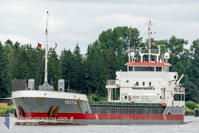
HESTIA
General Cargo
Current Trip
| Time Travelled | 2 days |
|---|---|
| Remaining Time | --- |
| Distance Travelled | 554.41 nm |
| Remaining Distance | --- |
| AVG Speed | 9.8 Knots |
| MAX Speed | 12.1 Knots |
| AVG Wind | 15.6 knots |
| MAX Wind | 22.8 knots |
| MIN Temp | 12.7°C / 54.86°F |
| MAX Temp | 14.8°C / 58.64°F |
| Draught | 3.5 m |
| Position Received | 11 h, 1 m ago |
Current Position
| Longitude | -10.28298° |
|---|---|
| Latitude | 51.43564° |
| Status | Under way using engine |
| Speed | 9.4 Knots |
| Course | 306.2° |
| Area | North Atlantic Ocean |
| Station | T-AIS |
| Position Received | 11 h, 1 m ago |
Info
Information
The current position of HESTIA is in North Atlantic Ocean with coordinates 51.43564° / -10.28298° as reported on 2024-06-18 02:49 by AIS to our vessel tracker app. The vessel's current speed is 9.4 Knots and is heading at the port of GALWAY. The estimated time of arrival as calculated by vessel tracking app is 2024-06-19 03:00 LT
The vessel HESTIA (IMO: 9411783, MMSI: 246827000) is a General Cargo that was built in 2011 ( 13 years old ). It's sailing under the flag of [NL] Netherlands.
In this page you can find informations about the vessels current position, last detected port calls, and current voyage information. If the vessels is not in coverage by AIS you will find the latest position.
The current position of HESTIA is detected by our AIS receivers and we are not responsible for the reliability of the data. The last position was recorded while the vessel was in Coverage by the Ais receivers of our vessel tracking app.
The current draught of HESTIA as reported by AIS is 3.5 meters
Weather
| Temperature | 12.7°C / 54.86°F |
|---|---|
| Wind Speed | 19 knots |
| Direction | 352° N |
| Pressure | 1017.5 hPa |
| Humidity | 88.5 % |
| Cloud Coverage | 70 % |
Featured Company
Last Port Calls
| Port | Arrival | Departure | Time In Port |
|---|---|---|---|
| 2024-06-14 16:47 | 2024-06-15 18:30 | 1 d | |
| 2024-06-13 06:39 | 2024-06-13 23:07 | 16 h | |
| 2024-06-12 05:33 | 2024-06-12 17:05 | 11 h | |
| 2024-06-10 07:46 | 2024-06-11 14:23 | 1 d | |
| 2024-06-09 03:03 | 2024-06-09 17:10 | 14 h | |
| 2024-06-07 10:03 | 2024-06-08 11:02 | 1 d | |
| 2024-06-05 17:37 | 2024-06-06 17:02 | 23 h | |
| 2024-06-05 17:16 | 2024-06-05 17:21 | 5 m | |
| 2024-06-04 04:53 | 2024-06-04 21:32 | 16 h | |
| 2024-06-01 07:55 | 2024-06-03 23:43 | 2 d |
Last Trips
| Origin | Departure | Destination | Arrival | Distance | |
|---|---|---|---|---|---|
| 2024-06-14 01:07 | 2024-06-14 17:47 | 146.87 nm | |||
| 2024-06-12 18:05 | 2024-06-13 08:39 | 147.35 nm | |||
| 2024-06-11 16:23 | 2024-06-12 06:33 | 145.76 nm | |||
| 2024-06-09 18:10 | 2024-06-10 09:46 | 145.83 nm | |||
| 2024-06-08 13:02 | 2024-06-09 04:03 | 146.29 nm | |||
| 2024-06-06 18:02 | 2024-06-07 12:03 | 146.34 nm | |||
| 2024-06-05 18:21 | 2024-06-05 18:37 | 0.59 nm | |||
| 2024-06-04 23:32 | 2024-06-05 18:16 | 145.32 nm | |||
| 2024-06-04 01:43 | 2024-06-04 06:53 | 33.02 nm | |||
| 2024-05-27 20:25 | 2024-06-01 09:55 | 1011.63 nm |
Events
| Time | Event | Details | Position / Dest | Info |
|---|---|---|---|---|
| 2024-06-18 02:49 | OUT of Coverage |
51.43564 / -10.28298
North Atlantic Ocean
IEGWY
|
Speed: 9.4 kn Course: 306.2° |
|
| 2024-06-18 02:49 | Detected in Sea | Irish part of the North Atlantic Ocean |
51.43564 / -10.28298
North Atlantic Ocean
IEGWY
|
Speed: 9.4 kn Course: 306.2° |
| 2024-06-18 02:49 | IN Coverage |
51.43564 / -10.28298
North Atlantic Ocean
IEGWY
|
Speed: 9.4 kn Course: 306.2° |
|
| 2024-06-18 01:05 | OUT of Coverage |
51.26992 / -9.92718
Celtic Sea
IEGWY
|
Speed: 10.1 kn Course: 305.1° |
|
| 2024-06-18 00:51 | IN Coverage |
51.24810 / -9.87819
Celtic Sea
IEGWY
|
Speed: 10.1 kn Course: 305.7° |
|
| 2024-06-17 22:54 | OUT of Coverage |
51.05438 / -9.45364
Celtic Sea
IEGWY
|
Speed: 10.3 kn Course: 306.1° |
|
| 2024-06-17 22:08 | Detected in Sea | Irish part of the Celtic Sea |
50.97507 / -9.28759
Celtic Sea
IEGWY
|
Speed: 10 kn Course: 306.8° |
| 2024-06-17 22:06 | IN Coverage |
50.97507 / -9.28759
Celtic Sea
IEGWY
|
Speed: 10 kn Course: 306.8° |
|
| 2024-06-17 14:59 | Status Changed | Default Under way using engine |
50.23905 / -7.72739
IEGWY
|
Speed: 10.4 kn Course: 306.4° |
| 2024-06-17 14:03 | OUT of Coverage |
50.14499 / -7.52872
Celtic Sea
IEGWY
|
Speed: 10.4 kn Course: 306.4° |