
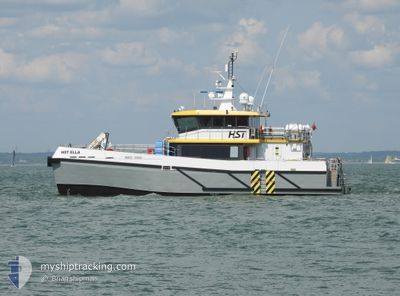
HST ELLA
High speed craft
Current Trip
STB-OWF
| Time Travelled | 8 h, 52 mins |
|---|---|
| Remaining Time | --- |
| Distance Travelled | 45.06 nm |
| Remaining Distance | --- |
| AVG Speed | 10.4 Knots |
| MAX Speed | 23.7 Knots |
| AVG Wind | 6 knots |
| MAX Wind | 7 knots |
| MIN Temp | 14.1°C / 57.38°F |
| MAX Temp | 14.6°C / 58.28°F |
| Draught | 1.4 m |
| Position Received | Now |
Current Position
| Longitude | -2.52162° |
|---|---|
| Latitude | 48.82523° |
| Status | Under way using engine |
| Speed | 1.1 Knots |
| Course | 264° |
| Area | English Channel |
| Station | T-AIS |
| Position Received | Now |
Info
Information
The current position of HST ELLA is in English Channel with coordinates 48.82523° / -2.52162° as reported on 2024-05-19 18:57 by AIS to our vessel tracker app. The vessel's current speed is 1.1 Knots
The vessel HST ELLA (IMO: 9943712, MMSI: 232036844) is a High speed craft It's sailing under the flag of [GB] United Kingdom.
In this page you can find informations about the vessels current position, last detected port calls, and current voyage information. If the vessels is not in coverage by AIS you will find the latest position.
The current position of HST ELLA is detected by our AIS receivers and we are not responsible for the reliability of the data. The last position was recorded while the vessel was in Coverage by the Ais receivers of our vessel tracking app.
The current draught of HST ELLA as reported by AIS is 1.4 meters
Weather
| Temperature | 14.3°C / 57.74°F |
|---|---|
| Wind Speed | 6 knots |
| Direction | 10° N |
| Pressure | 1012.4 hPa |
| Humidity | 86.9 % |
| Cloud Coverage | 1 % |
Featured Company
Last Port Calls
| Port | Arrival | Departure | Time In Port |
|---|---|---|---|
| 2024-05-19 09:17 | 2024-05-19 10:06 | 49 m | |
| 2024-05-18 20:50 | 2024-05-18 23:22 | 2 h | |
| 2024-05-18 09:26 | 2024-05-18 10:42 | 1 h | |
| 2024-05-17 20:42 | 2024-05-17 22:02 | 1 h | |
| 2024-05-16 20:46 | 2024-05-17 10:06 | 13 h | |
| 2024-05-16 11:58 | 2024-05-16 15:02 | 3 h | |
| 2024-05-14 11:42 | 2024-05-16 10:10 | 1 d | |
| 2024-05-14 07:38 | 2024-05-14 09:46 | 2 h | |
| 2024-05-13 22:42 | 2024-05-13 23:30 | 48 m | |
| 2024-05-10 18:02 | 2024-05-13 21:02 | 3 d |
Most Visited Ports (Last year)
| Port | Arrivals | |
|---|---|---|
| 77 | ||
| 45 | ||
| 10 | ||
| 7 | ||
| 5 | ||
| 1 |
Last Trips
| Origin | Departure | Destination | Arrival | Distance | |
|---|---|---|---|---|---|
| 2024-05-19 00:22 | 2024-05-19 10:17 | 63.46 nm | |||
| 2024-05-18 11:42 | 2024-05-18 21:50 | 68.88 nm | |||
| 2024-05-17 23:02 | 2024-05-18 10:26 | 80.44 nm | |||
| 2024-05-17 11:06 | 2024-05-17 21:42 | 67.98 nm | |||
| 2024-05-16 17:02 | 2024-05-16 21:46 | 54.28 nm | |||
| 2024-05-16 11:10 | 2024-05-16 13:58 | 37.66 nm | |||
| 2024-05-14 11:46 | 2024-05-14 12:42 | 39.68 nm | |||
| 2024-05-14 00:30 | 2024-05-14 09:38 | 59.07 nm | |||
| 2024-05-13 23:02 | 2024-05-13 23:42 | 40.66 nm | |||
| 2024-05-10 15:46 | 2024-05-10 20:02 | 39.96 nm |
Events
| Time | Event | Details | Position / Dest | Info |
|---|---|---|---|---|
| 2024-05-19 17:56 | STOP Moving | 15.08 nm, North West of SAINT CAST LE GUIDO |
48.82850 / -2.49579
STB-OWF
|
Speed: 0.3 kn Course: 43° |
| 2024-05-19 17:38 | START Moving | 15.04 nm, North West of SAINT CAST LE GUIDO |
48.81428 / -2.51690
STB-OWF
|
Speed: 3.3 kn Course: 48° |
| 2024-05-19 16:47 | STOP Moving | 15.04 nm, North West of SAINT CAST LE GUIDO |
48.82220 / -2.50487
STB-OWF
|
Speed: 0.3 kn Course: 349° |
| 2024-05-19 16:41 | START Moving | 14.76 nm, North West of SAINT CAST LE GUIDO |
48.81761 / -2.50190
STB-OWF
|
Speed: 3.6 kn Course: 79° |
| 2024-05-19 16:33 | ETA Changed | 2024/05/19 11:30 2024/05/18 12:00 |
48.81924 / -2.50129
STB-OWF
|
Speed: 0.7 kn Course: 89° |
| 2024-05-19 16:27 | STOP Moving | 14.86 nm, North West of SAINT CAST LE GUIDO |
48.82012 / -2.50151
STB-OWF
|
Speed: 0.3 kn Course: 29° |
| 2024-05-19 15:53 | START Moving | 14.62 nm, North West of SAINT CAST LE GUIDO |
48.80225 / -2.51916
STB-OWF
|
Speed: 8.6 kn Course: 289.1° |
| 2024-05-19 15:48 | STOP Moving | 14.47 nm, North West of SAINT CAST LE GUIDO |
48.80221 / -2.51412
STB-OWF
|
Speed: 0.1 kn Course: 34° |
| 2024-05-19 15:47 | START Moving | 14.47 nm, North West of SAINT CAST LE GUIDO |
48.80154 / -2.51520
STB-OWF
|
Speed: 7.7 kn Course: 41.9° |
| 2024-05-19 15:42 | STOP Moving | 14.45 nm, North West of SAINT CAST LE GUIDO |
48.79684 / -2.52061
STB-OWF
|
Speed: 0.3 kn Course: 309° |