
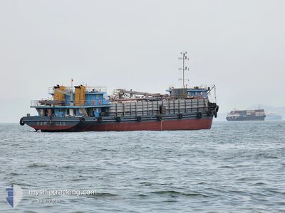
HUI HANG 828
Tanker
Current Trip
SHANG HAI
| Time Travelled | 1 day |
|---|---|
| Remaining Time | --- |
| Distance Travelled | 12.06 nm |
| Remaining Distance | --- |
| AVG Speed | 4.8 Knots |
| MAX Speed | 6.1 Knots |
| AVG Wind | 5.9 knots |
| MAX Wind | 11.8 knots |
| MIN Temp | 14.1°C / 57.38°F |
| MAX Temp | 17.2°C / 62.96°F |
| Draught | 6.5 m |
| Position Received | 19 h, 22 m ago |
Current Position
| Longitude | 120.37752° |
|---|---|
| Latitude | 35.97726° |
| Status | At anchor |
| Speed | 0.1 Knots |
| Course | 178° |
| Area | Yellow Sea |
| Station | T-AIS |
| Position Received | 19 h, 22 m ago |
Info
Information
The current position of HUI HANG 828 is in Yellow Sea with coordinates 35.97726° / 120.37752° as reported on 2024-05-19 10:34 by AIS to our vessel tracker app. The vessel's current speed is 0.1 Knots
The vessel HUI HANG 828 (IMO: 9912385, MMSI: 413232440) is a Tanker It's sailing under the flag of [CN] China.
In this page you can find informations about the vessels current position, last detected port calls, and current voyage information. If the vessels is not in coverage by AIS you will find the latest position.
The current position of HUI HANG 828 is detected by our AIS receivers and we are not responsible for the reliability of the data. The last position was recorded while the vessel was in Coverage by the Ais receivers of our vessel tracking app.
The current draught of HUI HANG 828 as reported by AIS is 6.5 meters
Weather
| Temperature | 16.2°C / 61.16°F |
|---|---|
| Wind Speed | 7 knots |
| Direction | 131° SE |
| Pressure | 1016 hPa |
| Humidity | 89 % |
| Cloud Coverage | 79 % |
Featured Company
Last Port Calls
| Port | Arrival | Departure | Time In Port |
|---|---|---|---|
| 2024-05-18 14:03 | 2024-05-18 14:16 | 13 m | |
| 2024-05-15 23:24 | 2024-05-17 02:00 | 1 d | |
| 2024-05-07 00:16 | 2024-05-07 23:48 | 23 h | |
| 2024-05-02 06:45 | 2024-05-03 05:57 | 23 h | |
| 2024-04-25 06:59 | 2024-04-26 06:27 | 23 h | |
| 2024-04-21 07:02 | 2024-04-22 08:56 | 1 d | |
| 2024-04-14 13:58 | 2024-04-15 20:31 | 1 d | |
| 2024-04-13 07:58 | 2024-04-14 08:22 | 1 d | |
| 2024-04-11 00:18 | 2024-04-12 05:42 | 1 d | |
| 2024-04-07 00:38 | 2024-04-10 01:40 | 3 d |
Last Trips
| Origin | Departure | Destination | Arrival | Distance | |
|---|---|---|---|---|---|
| 2024-05-17 10:00 | 2024-05-18 22:03 | 428.02 nm | |||
| 2024-05-08 07:48 | 2024-05-16 07:24 | 620.80 nm | |||
| 2024-05-03 13:57 | 2024-05-07 08:16 | 626.45 nm | |||
| 2024-04-26 14:27 | 2024-05-02 14:45 | 605.24 nm | |||
| 2024-04-22 16:56 | 2024-04-25 14:59 | 595.03 nm | |||
| 2024-04-16 02:31 | 2024-04-21 15:02 | 433.69 nm | |||
| 2024-04-14 14:22 | 2024-04-14 19:58 | 56.31 nm | |||
| 2024-04-12 13:42 | 2024-04-13 13:58 | 284.07 nm | |||
| 2024-04-10 09:40 | 2024-04-11 08:18 | 202.23 nm | |||
| 2024-04-02 20:13 | 2024-04-07 08:38 | 436.85 nm |
Events
| Time | Event | Details | Position / Dest | Info |
|---|---|---|---|---|
| 2024-05-19 10:37 | Status Changed | Default At anchor |
35.97728 / 120.37759
SHANG HAI
|
Speed: 0.1 kn Course: 178° |
| 2024-05-19 10:34 | Status Changed | At anchor Default |
35.97726 / 120.37752
SHANG HAI
|
Speed: Course: 179° |
| 2024-05-19 10:34 | OUT of Coverage |
35.97726 / 120.37752
Yellow Sea
|
Speed: 0.1 kn Course: 131.2° |
|
| 2024-05-19 10:22 | IN Coverage |
35.97726 / 120.37752
Yellow Sea
|
Speed: 0.1 kn Course: 131.2° |
|
| 2024-05-18 14:40 | STOP Moving | 7.05 nm, South East of QINGDAO |
35.97686 / 120.37673
SHANG HAI
|
Speed: 0.2 kn Course: 133° |
| 2024-05-18 14:16 | PORT DEPARTURE |
|
36.00245 / 120.34718
SHANG HAI
|
Speed: 10.1 kn Course: 140° |
| 2024-05-18 14:03 | PORT ARRIVAL |
|
36.02269 / 120.35352
[CN] QINGDAO
|
Speed: 11.7 kn Course: 282° |
| 2024-05-18 12:13 | Status Changed | Default Under way using engine |
35.94559 / 120.75416
SHANG HAI
|
Speed: 9.7 kn Course: 290.2° |
| 2024-05-18 12:06 | Change Sea Area | Chinese part of the Yellow Sea Chinese part of the South China Sea |
35.94036 / 120.77920
Yellow Sea
|
Speed: 9.7 kn Course: 290.2° |
| 2024-05-18 12:06 | OUT of Coverage |
35.94036 / 120.77920
Yellow Sea
|
Speed: 9.7 kn Course: 290.2° |