
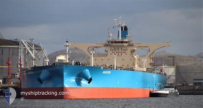
HUNTER
Tanker
Current Trip
VN THO
| Time Travelled | 6 days |
|---|---|
| Remaining Time | --- |
| Distance Travelled | 1032.77 nm |
| Remaining Distance | --- |
| AVG Speed | 11.8 Knots |
| MAX Speed | 14.6 Knots |
| AVG Wind | 5.9 knots |
| MAX Wind | 19 knots |
| MIN Temp | 31.5°C / 88.7°F |
| MAX Temp | 38.4°C / 101.12°F |
| Draught | 20.6 m |
| Position Received | 1 m ago |
Current Position
| Longitude | 55.82797° |
|---|---|
| Latitude | 26.06032° |
| Status | Under way using engine |
| Speed | 0.7 Knots |
| Course | 13° |
| Area | Persian Gulf |
| Station | T-AIS |
| Position Received | 1 m ago |
Info
Information
The current position of HUNTER is in Persian Gulf with coordinates 26.06032° / 55.82797° as reported on 2024-06-27 17:43 by AIS to our vessel tracker app. The vessel's current speed is 0.7 Knots
The vessel HUNTER (IMO: 9896414, MMSI: 636019738) is a Tanker It's sailing under the flag of [LR] Liberia.
In this page you can find informations about the vessels current position, last detected port calls, and current voyage information. If the vessels is not in coverage by AIS you will find the latest position.
The current position of HUNTER is detected by our AIS receivers and we are not responsible for the reliability of the data. The last position was recorded while the vessel was in Coverage by the Ais receivers of our vessel tracking app.
The current draught of HUNTER as reported by AIS is 20.6 meters
Weather
| Temperature | 33°C / 91.4°F |
|---|---|
| Wind Speed | 2 knots |
| Direction | 196° SSW |
| Pressure | 996 hPa |
| Humidity | 64.6 % |
| Cloud Coverage | 4 % |
Featured Company
Last Port Calls
| Port | Arrival | Departure | Time In Port |
|---|---|---|---|
| 2024-06-19 16:44 | 2024-06-21 02:46 | 1 d | |
| 2024-06-14 23:13 | 2024-06-16 19:12 | 1 d | |
| 2024-06-11 13:33 | 2024-06-12 03:08 | 13 h | |
| 2024-06-07 19:58 |
Most Visited Ports (Last year)
| Port | Arrivals | |
|---|---|---|
| 2 | ||
| 2 | ||
| 1 | ||
| 1 | ||
| 1 | ||
| 1 |
Last Trips
| Origin | Departure | Destination | Arrival | Distance | |
|---|---|---|---|---|---|
| 2024-06-16 23:12 | 2024-06-19 20:44 | 47.93 nm | |||
| 2024-06-12 06:08 | 2024-06-15 03:13 | 393.25 nm | |||
| 2024-06-07 22:58 | 2024-06-11 16:33 | 14.56 nm |
Events
| Time | Event | Details | Position / Dest | Info |
|---|---|---|---|---|
| 2024-06-27 11:11 | Status Changed | Under way using engine Default |
25.65529 / 54.96171
VN THO
|
Speed: 13.8 kn Course: 89° |
| 2024-06-27 11:03 | Status Changed | Default Under way using engine |
25.65500 / 54.92260
VN THO
|
Speed: 13.8 kn Course: 89.3° |
| 2024-06-27 10:45 | Status Changed | Under way using engine Default |
25.65603 / 54.84735
VN THO
|
Speed: 13.9 kn Course: 95° |
| 2024-06-27 10:34 | Status Changed | Default Under way using engine |
25.65981 / 54.79934
VN THO
|
Speed: 13.9 kn Course: 94.9° |
| 2024-06-27 09:28 | Change Sea Area | United Arab Emirates part of the Persian Gulf Iranian part of the Persian Gulf |
25.69103 / 54.50987
Persian Gulf
VN THO
|
Speed: 14.2 kn Course: 95.5° |
| 2024-06-27 07:33 | Status Changed | Under way using engine Default |
25.88955 / 54.05027
VN THO
|
Speed: 14.3 kn Course: 109° |
| 2024-06-27 07:13 | Status Changed | Default Under way using engine |
25.91558 / 53.96626
VN THO
|
Speed: 14.2 kn Course: 112° |
| 2024-06-27 06:34 | Status Changed | Under way using engine Default |
25.97340 / 53.80543
VN THO
|
Speed: 14 kn Course: 110° |
| 2024-06-27 06:30 | Status Changed | Default Under way using engine |
25.98001 / 53.78506
VN THO
|
Speed: 13.9 kn Course: 109.9° |
| 2024-06-27 04:55 | Status Changed | Under way using engine Default |
26.09545 / 53.39408
VN THO
|
Speed: 13.1 kn Course: 108° |