
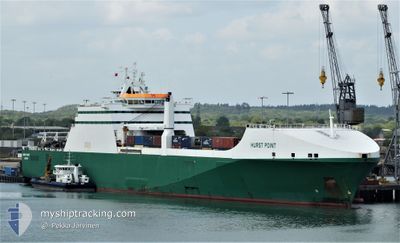
HURST POINT
Ro-Ro Cargo
Current Trip
| Time Travelled | 22 h, 57 mins |
|---|---|
| Remaining Time | 2 days |
| Distance Travelled | 367.80 nm |
| Remaining Distance | 846.58 nm |
| AVG Speed | 16 Knots |
| MAX Speed | 19.8 Knots |
| AVG Wind | 10.6 knots |
| MAX Wind | 14.9 knots |
| MIN Temp | 8.6°C / 47.48°F |
| MAX Temp | 14.6°C / 58.28°F |
| Draught | 5.7 m |
| Position Received | 14 h, 55 m ago |
Current Position
| Longitude | -3.96865° |
|---|---|
| Latitude | 49.63809° |
| Status | Under way using engine |
| Speed | 16.6 Knots |
| Course | 235° |
| Area | English Channel |
| Station | T-AIS |
| Position Received | 14 h, 55 m ago |
Info
Information
The current position of HURST POINT is in English Channel with coordinates 49.63809° / -3.96865° as reported on 2024-06-11 14:13 by AIS to our vessel tracker app. The vessel's current speed is 16.6 Knots and is heading at the port of GIBRALTAR. The estimated time of arrival as calculated by vessel tracking app is 2024-06-14 09:47 LT
The vessel HURST POINT (IMO: 9234068, MMSI: 235500000) is a Ro-Ro Cargo that was built in 2002 ( 22 years old ). It's sailing under the flag of [GB] United Kingdom.
In this page you can find informations about the vessels current position, last detected port calls, and current voyage information. If the vessels is not in coverage by AIS you will find the latest position.
The current position of HURST POINT is detected by our AIS receivers and we are not responsible for the reliability of the data. The last position was recorded while the vessel was in Coverage by the Ais receivers of our vessel tracking app.
The current draught of HURST POINT as reported by AIS is 5.7 meters
Weather
| Temperature | 14.5°C / 58.1°F |
|---|---|
| Wind Speed | 5 knots |
| Direction | 51° NE |
| Pressure | 1023.8 hPa |
| Humidity | 65 % |
| Cloud Coverage | 2 % |
Featured Company
Last Port Calls
| Port | Arrival | Departure | Time In Port |
|---|---|---|---|
| 2024-06-07 05:38 | 2024-06-11 06:11 | 4 d | |
| 2024-06-02 03:19 | 2024-06-02 17:33 | 14 h | |
| 2024-05-27 09:34 | 2024-05-28 05:27 | 19 h | |
| 2024-05-23 04:56 | 2024-05-23 17:03 | 12 h | |
| 2024-05-17 05:11 | 2024-05-18 06:13 | 1 d | |
| 2024-05-10 06:32 | 2024-05-13 15:25 | 3 d | |
| 2024-05-04 04:16 | 2024-05-04 13:52 | 9 h | |
| 2024-04-27 05:05 | 2024-04-27 12:22 | 7 h | |
| 2024-04-22 04:25 | 2024-04-23 06:20 | 1 d | |
| 2024-04-19 01:59 | 2024-04-19 10:56 | 8 h |
Most Visited Ports (Last year)
| Port | Arrivals | |
|---|---|---|
| 13 | ||
| 4 | ||
| 4 | ||
| 2 | ||
| 2 | ||
| 2 |
Last Trips
| Origin | Departure | Destination | Arrival | Distance | |
|---|---|---|---|---|---|
| 2024-06-02 20:33 | 2024-06-07 06:38 | 1320.62 nm | |||
| 2024-05-28 06:27 | 2024-06-02 06:19 | 1333.89 nm | |||
| 2024-05-23 19:03 | 2024-05-27 10:34 | 1009.09 nm | |||
| 2024-05-18 07:13 | 2024-05-23 06:56 | 987.05 nm | |||
| 2024-05-13 17:25 | 2024-05-17 06:11 | 1216.56 nm | |||
| 2024-05-04 16:52 | 2024-05-10 08:32 | 1906.42 nm | |||
| 2024-04-27 14:22 | 2024-05-04 07:16 | 1919.45 nm | |||
| 2024-04-23 07:20 | 2024-04-27 07:05 | 1242.31 nm | |||
| 2024-04-19 12:56 | 2024-04-22 05:25 | 502.33 nm | |||
| 2024-04-17 08:56 | 2024-04-19 03:59 | 431.51 nm |
Events
| Time | Event | Details | Position / Dest | Info |
|---|---|---|---|---|
| 2024-06-11 14:19 | Status Changed | Default Under way using engine |
49.62135 / -4.00501
GI GIB
|
Speed: 16.6 kn Course: 235° |
| 2024-06-11 14:13 | OUT of Coverage |
49.63809 / -3.96865
English Channel
GI GIB
|
Speed: 16.6 kn Course: 235° |
|
| 2024-06-11 14:05 | Status Changed | Under way using engine Default |
49.65569 / -3.92470
GI GIB
|
Speed: 16.3 kn Course: 250° |
| 2024-06-11 13:51 | Status Changed | Default Under way using engine |
49.67931 / -3.82605
GI GIB
|
Speed: 18.2 kn Course: 235° |
| 2024-06-11 13:46 | Change Sea Area | United Kingdom part of the English Channel Guernsey part of the English Channel |
49.68682 / -3.79704
English Channel
GI GIB
|
Speed: 18.2 kn Course: 235° |
| 2024-06-11 13:46 | Status Changed | Under way using engine Default |
49.68891 / -3.79230
GI GIB
|
Speed: 18.3 kn Course: 237° |
| 2024-06-11 13:27 | IN Coverage |
49.68682 / -3.79704
English Channel
GI GIB
|
Speed: 18.2 kn Course: 235° |
|
| 2024-06-11 11:27 | Status Changed | Default Under way using engine |
49.98692 / -2.86782
GI GIB
|
Speed: 16.4 kn Course: 255.2° |
| 2024-06-11 11:20 | OUT of Coverage |
49.99616 / -2.81467
English Channel
GI GIB
|
Speed: 16.4 kn Course: 255.2° |
|
| 2024-06-11 11:02 | Status Changed | Under way using engine Default |
50.01655 / -2.69542
GI GIB
|
Speed: 16.1 kn Course: 255° |