
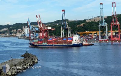
HYPERION
Container Ship
Current Trip
CN TXG
| Time Travelled | 18 h, 51 mins |
|---|---|
| Remaining Time | --- |
| Distance Travelled | 219.04 nm |
| Remaining Distance | --- |
| AVG Speed | 15.2 Knots |
| MAX Speed | 17.8 Knots |
| AVG Wind | 13.9 knots |
| MAX Wind | 17.4 knots |
| MIN Temp | 16°C / 60.8°F |
| MAX Temp | 19.6°C / 67.28°F |
| Draught | 5.8 m |
| Position Received | 15 h, 47 m ago |
Current Position
| Longitude | 118.79940° |
|---|---|
| Latitude | 38.77777° |
| Status | Under way using engine |
| Speed | 15.8 Knots |
| Course | 97° |
| Area | Yellow Sea |
| Station | T-AIS |
| Position Received | 15 h, 47 m ago |
Info
Information
The current position of HYPERION is in Yellow Sea with coordinates 38.77777° / 118.79940° as reported on 2024-05-28 19:28 by AIS to our vessel tracker app. The vessel's current speed is 15.8 Knots
The vessel HYPERION (IMO: 9403853, MMSI: 309947000) is a Container Ship that was built in 2008 ( 16 years old ). It's sailing under the flag of [BS] Bahamas.
In this page you can find informations about the vessels current position, last detected port calls, and current voyage information. If the vessels is not in coverage by AIS you will find the latest position.
The current position of HYPERION is detected by our AIS receivers and we are not responsible for the reliability of the data. The last position was recorded while the vessel was in Coverage by the Ais receivers of our vessel tracking app.
The current draught of HYPERION as reported by AIS is 5.8 meters
Weather
| Temperature | 18.5°C / 65.3°F |
|---|---|
| Wind Speed | 15 knots |
| Direction | 186° S |
| Pressure | 1007.7 hPa |
| Humidity | 68.3 % |
| Cloud Coverage | 48 % |
Featured Company
Last Port Calls
| Port | Arrival | Departure | Time In Port |
|---|---|---|---|
| 2024-05-28 04:53 | 2024-05-28 16:25 | 11 h | |
| 2024-05-23 22:32 | 2024-05-24 03:16 | 4 h | |
| 2024-05-23 02:20 | 2024-05-23 08:17 | 5 h | |
| 2024-05-22 12:44 | 2024-05-23 02:16 | 13 h | |
| 2024-05-21 21:44 | 2024-05-22 06:04 | 8 h | |
| 2024-05-20 12:00 | 2024-05-21 01:11 | 13 h | |
| 2024-05-20 03:56 | 2024-05-20 09:20 | 5 h | |
| 2024-05-19 01:24 | 2024-05-19 09:00 | 7 h | |
| 2024-05-17 11:52 | 2024-05-17 17:08 | 5 h | |
| 2024-05-14 05:48 | 2024-05-14 15:52 | 10 h |
Last Trips
| Origin | Departure | Destination | Arrival | Distance | |
|---|---|---|---|---|---|
| 2024-05-24 12:16 | 2024-05-28 12:53 | 848.09 nm | |||
| 2024-05-23 17:17 | 2024-05-24 07:32 | 85.47 nm | |||
| 2024-05-23 11:16 | 2024-05-23 11:20 | 0.76 nm | |||
| 2024-05-22 15:04 | 2024-05-22 21:44 | 94.24 nm | |||
| 2024-05-21 10:11 | 2024-05-22 06:44 | 37.36 nm | |||
| 2024-05-20 18:20 | 2024-05-20 21:00 | 35.64 nm | |||
| 2024-05-19 18:00 | 2024-05-20 12:56 | 244.32 nm | |||
| 2024-05-18 01:08 | 2024-05-19 10:24 | 505.58 nm | |||
| 2024-05-14 23:52 | 2024-05-17 19:52 | 536.65 nm | |||
| 2024-05-09 12:28 | 2024-05-14 13:48 | 848.07 nm |
Events
| Time | Event | Details | Position / Dest | Info |
|---|---|---|---|---|
| 2024-05-29 06:57 | STOP Moving | 9.45 nm, East of DALIAN |
39.00033 / 121.88541
CN TXG
|
Speed: 0.2 kn Course: 302° |
| 2024-05-28 19:34 | Status Changed | Default Under way using engine |
38.77443 / 118.82982
CN TXG
|
Speed: 15.8 kn Course: 97° |
| 2024-05-28 19:28 | OUT of Coverage |
38.77777 / 118.79940
Yellow Sea
|
Speed: 15.8 kn Course: 97° |
|
| 2024-05-28 19:02 | Change Sea Area | Chinese part of the Yellow Sea South Korean part of the Yellow Sea |
38.79892 / 118.64453
Yellow Sea
|
Speed: 15.8 kn Course: 99° |
| 2024-05-28 19:00 | Status Changed | Under way using engine Default |
38.79985 / 118.63798
CN TXG
|
Speed: 15.8 kn Course: 98° |
| 2024-05-28 18:54 | IN Coverage |
38.79892 / 118.64453
Yellow Sea
|
Speed: 15.8 kn Course: 99° |
|
| 2024-05-28 16:25 | PORT DEPARTURE |
|
38.95858 / 117.87354
CN TXG
|
Speed: 12.4 kn Course: 105° |
| 2024-05-28 15:50 | START Moving |
38.99900 / 117.78037
[CN] TIANJIN
|
Speed: 4.7 kn Course: 160° |
|
| 2024-05-28 05:36 | STOP Moving |
38.99995 / 117.77563
[CN] TIANJIN
|
Speed: Course: 348° |
|
| 2024-05-28 04:53 | PORT ARRIVAL |
|
38.96041 / 117.85998
[CN] TIANJIN
|
Speed: 11.4 kn Course: 279° |