
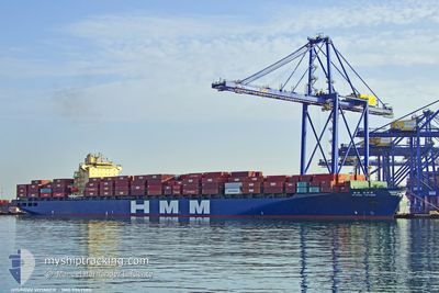
HYUNDAI VOYAGER
Container Ship
Current Trip
| Trip Time | 4 days |
|---|---|
| Trip Distance | 578.68 nm |
| AVG Speed | 9.9 Knots |
| MAX Speed | 12.8 Knots |
| Draught | 12 m |
| AVG Wind | 9.2 knots |
| MAX Wind | 19 knots |
| MIN Temp | 26.1°C / 78.98°F |
| MAX Temp | 30.9°C / 87.62°F |
| Position Received | Now |
Current Position
| Longitude | 120.94748° |
|---|---|
| Latitude | 14.60263° |
| Status | Under way using engine |
| Speed | 1.1 Knots |
| Course | 18° |
| Area | South China Sea |
| Station | T-AIS |
| Position Received | Now |
Info
Information
The current position of HYUNDAI VOYAGER is in South China Sea with coordinates 14.60263° / 120.94748° as reported on 2024-05-29 00:32 by AIS to our vessel tracker app. The vessel's current speed is 1.1 Knots and is currently inside the port of MANILA.
The vessel HYUNDAI VOYAGER (IMO: 9347580, MMSI: 538007486) is a Container Ship that was built in 2008 ( 16 years old ). It's sailing under the flag of [MH] Marshall Is.
In this page you can find informations about the vessels current position, last detected port calls, and current voyage information. If the vessels is not in coverage by AIS you will find the latest position.
The current position of HYUNDAI VOYAGER is detected by our AIS receivers and we are not responsible for the reliability of the data. The last position was recorded while the vessel was in Coverage by the Ais receivers of our vessel tracking app.
The current draught of HYUNDAI VOYAGER as reported by AIS is 12 meters
Weather
| Temperature | 28.9°C / 84.02°F |
|---|---|
| Wind Speed | 2 knots |
| Direction | 142° SE |
| Pressure | 1008.2 hPa |
| Humidity | 76.5 % |
| Cloud Coverage | 100 % |
Featured Company
Last Port Calls
| Port | Arrival | Departure | Time In Port |
|---|---|---|---|
| 2024-05-29 00:14 | |||
| 2024-05-24 15:45 | 2024-05-24 23:53 | 8 h | |
| 2024-05-22 12:04 | 2024-05-22 22:52 | 10 h | |
| 2024-05-21 02:40 | 2024-05-21 15:40 | 13 h | |
| 2024-05-16 15:52 | 2024-05-17 12:16 | 20 h | |
| 2024-05-12 06:46 | 2024-05-13 03:29 | 20 h | |
| 2024-04-04 10:40 | 2024-04-05 03:56 | 17 h | |
| 2024-03-30 18:27 | 2024-04-01 14:15 | 1 d | |
| 2024-03-26 01:22 | 2024-03-26 15:16 | 13 h | |
| 2024-03-22 01:35 | 2024-03-23 07:22 | 1 d |
Last Trips
| Origin | Departure | Destination | Arrival | Distance | |
|---|---|---|---|---|---|
| 2024-05-25 07:53 | 2024-05-29 08:14 | 578.68 nm | |||
| 2024-05-23 06:52 | 2024-05-24 23:45 | 535.11 nm | |||
| 2024-05-21 23:40 | 2024-05-22 20:04 | 224.58 nm | |||
| 2024-05-17 20:16 | 2024-05-21 10:40 | 413.34 nm | |||
| 2024-05-13 12:29 | 2024-05-16 23:52 | 509.86 nm | |||
| 2024-04-05 06:56 | 2024-05-12 15:46 | 14731.61 nm | |||
| 2024-04-01 16:15 | 2024-04-04 13:40 | 1024.60 nm | |||
| 2024-03-26 16:16 | 2024-03-30 19:27 | 531.43 nm | |||
| 2024-03-23 08:22 | 2024-03-26 02:22 | 220.37 nm | |||
| 2024-02-14 11:19 | 2024-03-22 02:35 | 13425.15 nm |
Events
| Time | Event | Details | Position / Dest | Info |
|---|---|---|---|---|
| 2024-05-29 00:14 | PORT ARRIVAL |
|
14.60451 / 120.93292
[PH] MANILA
|
Speed: 5.7 kn Course: 96° |
| 2024-05-28 23:11 | ETA Changed | 2024/05/29 00:01 2024/05/28 22:00 |
14.56353 / 120.78391
TWKHH>PHMNL
|
Speed: 6.5 kn Course: 63° |
| 2024-05-28 23:10 | Status Changed | Under way using engine Default |
14.56337 / 120.78360
TWKHH>PHMNL
|
Speed: 5.6 kn Course: 64° |
| 2024-05-28 23:06 | Status Changed | Default Under way using engine |
14.56029 / 120.77696
TWKHH>PHMNL
|
Speed: 5.9 kn Course: 63° |
| 2024-05-28 22:51 | START Moving | 8.25 nm, East of LIMAY |
14.55049 / 120.75347
TWKHH>PHMNL
|
Speed: 5.9 kn Course: 67° |
| 2024-05-28 21:31 | STOP Moving | 8.02 nm, East of LIMAY |
14.54216 / 120.75194
TWKHH>PHMNL
|
Speed: 0.3 kn Course: 14° |
| 2024-05-28 20:46 | Draught Changed | 12 12.1 |
14.48913 / 120.74739
TWKHH>PHMNL
|
Speed: 5.5 kn Course: 14° |
| 2024-05-28 20:46 | ETA Changed | 2024/05/28 22:00 2024/05/27 23:00 |
14.48913 / 120.74739
TWKHH>PHMNL
|
Speed: 5.5 kn Course: 14° |
| 2024-05-28 20:16 | Status Changed | Under way using engine Default |
14.43816 / 120.72433
TWKHH>PHMNL
|
Speed: 8.3 kn Course: 47° |
| 2024-05-28 20:13 | Status Changed | Default Under way using engine |
14.43370 / 120.71928
TWKHH>PHMNL
|
Speed: 8.6 kn Course: 46° |