
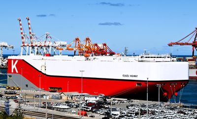
IGUAZU HIGHWAY
Cargo
Current Trip
| Time Travelled | 8 days |
|---|---|
| Remaining Time | 5 h, 46 mins |
| Distance Travelled | 3535.71 nm |
| Remaining Distance | 106.66 nm |
| AVG Speed | 16.3 Knots |
| MAX Speed | 21 Knots |
| AVG Wind | 12.8 knots |
| MAX Wind | 29 knots |
| MIN Temp | 12.5°C / 54.5°F |
| MAX Temp | 25.5°C / 77.9°F |
| Draught | 10 m |
| Position Received | 4 m ago |
Current Position
| Longitude | -76.06163° |
|---|---|
| Latitude | 37.58470° |
| Status | Under way using engine |
| Speed | 16.9 Knots |
| Course | 321.1° |
| Area | North Atlantic Ocean |
| Station | T-AIS |
| Position Received | 4 m ago |
Info
Information
The current position of IGUAZU HIGHWAY is in North Atlantic Ocean with coordinates 37.58470° / -76.06163° as reported on 2024-06-16 06:56 by AIS to our vessel tracker app. The vessel's current speed is 16.9 Knots and is heading at the port of BALTIMORE. The estimated time of arrival as calculated by vessel tracking app is 2024-06-16 12:47 LT
The vessel IGUAZU HIGHWAY (IMO: 9827243, MMSI: 353706000) is a Cargo It's sailing under the flag of [PA] Panama.
In this page you can find informations about the vessels current position, last detected port calls, and current voyage information. If the vessels is not in coverage by AIS you will find the latest position.
The current position of IGUAZU HIGHWAY is detected by our AIS receivers and we are not responsible for the reliability of the data. The last position was recorded while the vessel was in Coverage by the Ais receivers of our vessel tracking app.
The current draught of IGUAZU HIGHWAY as reported by AIS is 10 meters
Weather
| Temperature | 22.6°C / 72.68°F |
|---|---|
| Wind Speed | 6 knots |
| Direction | 132° SE |
| Pressure | 1019.6 hPa |
| Humidity | 69.4 % |
| Cloud Coverage | 20 % |
Featured Company
Last Port Calls
| Port | Arrival | Departure | Time In Port |
|---|---|---|---|
| 2024-06-06 23:51 | 2024-06-07 17:18 | 17 h | |
| 2024-06-03 14:17 | 2024-06-05 14:46 | 2 d | |
| 2024-05-27 20:43 | 2024-06-02 04:53 | 5 d | |
| 2024-05-24 20:09 | 2024-05-25 22:49 | 1 d | |
| 2024-05-16 13:58 | 2024-05-17 19:48 | 1 d | |
| 2024-05-13 21:04 | 2024-05-14 23:16 | 1 d | |
| 2024-04-10 02:34 | 2024-04-10 15:51 | 13 h | |
| 2024-04-10 01:56 | 2024-04-10 02:10 | 13 m | |
| 2024-04-01 21:39 | 2024-04-02 09:15 | 11 h | |
| 2024-04-01 08:19 |
Last Trips
| Origin | Departure | Destination | Arrival | Distance | |
|---|---|---|---|---|---|
| 2024-06-05 16:46 | 2024-06-07 00:51 | 466.93 nm | |||
| 2024-06-02 06:53 | 2024-06-03 16:17 | 399.72 nm | |||
| 2024-05-25 23:49 | 2024-05-27 22:43 | 559.20 nm | |||
| 2024-05-17 22:48 | 2024-05-24 21:09 | 2745.37 nm | |||
| 2024-05-15 02:16 | 2024-05-16 16:58 | 434.54 nm | |||
| 2024-04-10 23:51 | 2024-05-14 00:04 | 12654.36 nm | |||
| 2024-04-10 10:10 | 2024-04-10 10:34 | 1.26 nm | |||
| 2024-04-02 18:15 | 2024-04-10 09:56 | 2825.73 nm | |||
| 2024-04-01 17:19 | 2024-04-02 06:39 | 125.05 nm |
Events
| Time | Event | Details | Position / Dest | Info |
|---|---|---|---|---|
| 2024-06-16 06:20 | Status Changed | Under way using engine Default |
37.42280 / -76.08649
GBSOU>USBAL
|
Speed: 17.7 kn Course: 347° |
| 2024-06-16 06:19 | Status Changed | Default Under way using engine |
37.42142 / -76.08608
GBSOU>USBAL
|
Speed: 17.2 kn Course: 350.3° |
| 2024-06-16 06:04 | Status Changed | Under way using engine Default |
37.34954 / -76.08054
GBSOU>USBAL
|
Speed: 17.2 kn Course: 21° |
| 2024-06-16 05:51 | Status Changed | Default Under way using engine |
37.29288 / -76.11327
GBSOU>USBAL
|
Speed: 16.5 kn Course: 16.6° |
| 2024-06-16 05:45 | Status Changed | Under way using engine Default |
37.26578 / -76.12416
GBSOU>USBAL
|
Speed: 16.4 kn Course: 17° |
| 2024-06-16 05:43 | Status Changed | Default Under way using engine |
37.25744 / -76.12730
GBSOU>USBAL
|
Speed: 16.3 kn Course: 17.9° |
| 2024-06-16 05:39 | Status Changed | Under way using engine Default |
37.23633 / -76.13471
GBSOU>USBAL
|
Speed: 16.3 kn Course: 18° |
| 2024-06-16 05:35 | Status Changed | Default Under way using engine |
37.22204 / -76.14059
GBSOU>USBAL
|
Speed: 16.4 kn Course: 12° |
| 2024-06-16 04:51 | Draught Changed | 10 10.1 |
37.03779 / -76.06541
GBSOU>USBAL
|
Speed: 17 kn Course: 322.5° |
| 2024-06-16 04:51 | ETA Changed | 2024/06/16 05:00 2024/06/15 23:00 |
37.03779 / -76.06541
GBSOU>USBAL
|
Speed: 17 kn Course: 322.5° |