
IMI
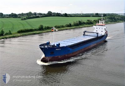
General Cargo
Current Trip
| Time Travelled | 6 days |
|---|---|
| Remaining Time | 4 days |
| Distance Travelled | 1006.71 nm |
| Remaining Distance | 601.13 nm |
| AVG Speed | 7.1 Knots |
| MAX Speed | 11.6 Knots |
| AVG Wind | 14.1 knots |
| MAX Wind | 30 knots |
| MIN Temp | 5.8°C / 42.44°F |
| MAX Temp | 19.4°C / 66.92°F |
| Draught | 5.9 m |
| Position Received | 2 m ago |
Current Position
| Longitude | 4.43374° |
|---|---|
| Latitude | 61.64948° |
| Status | Under way using engine |
| Speed | 6.3 Knots |
| Course | 181.3° |
| Area | Norwegian Sea |
| Station | T-AIS |
| Position Received | 2 m ago |
Info
Information
The current position of IMI is in Norwegian Sea with coordinates 61.64948° / 4.43374° as reported on 2024-06-26 05:23 by AIS to our vessel tracker app. The vessel's current speed is 6.3 Knots and is heading at the port of ROTTERDAM. The estimated time of arrival as calculated by vessel tracking app is 2024-06-30 08:44 LT
The vessel IMI (IMO: 9063873, MMSI: 308192000) is a General Cargo that was built in 1993 ( 31 years old ). It's sailing under the flag of [BS] Bahamas.
In this page you can find informations about the vessels current position, last detected port calls, and current voyage information. If the vessels is not in coverage by AIS you will find the latest position.
The current position of IMI is detected by our AIS receivers and we are not responsible for the reliability of the data. The last position was recorded while the vessel was in Coverage by the Ais receivers of our vessel tracking app.
The current draught of IMI as reported by AIS is 5.9 meters
Weather
| Temperature | 11.6°C / 52.88°F |
|---|---|
| Wind Speed | 12 knots |
| Direction | 38° NE |
| Pressure | 1018.3 hPa |
| Humidity | 88.1 % |
| Cloud Coverage | 94 % |
Featured Company
Last Port Calls
| Port | Arrival | Departure | Time In Port |
|---|---|---|---|
| 2024-06-16 19:49 | 2024-06-19 17:02 | 2 d | |
| 2024-06-04 22:27 | 2024-06-06 07:08 | 1 d | |
| 2024-06-01 20:53 | 2024-06-03 15:11 | 1 d | |
| 2024-05-30 15:32 | 2024-05-31 11:47 | 20 h | |
| 2024-05-25 11:43 | 2024-05-26 02:21 | 14 h | |
| 2024-05-18 11:59 | 2024-05-20 18:50 | 2 d | |
| 2024-05-07 20:32 | 2024-05-08 21:00 | 1 d | |
| 2024-05-05 08:52 | 2024-05-06 12:16 | 1 d | |
| 2024-05-04 02:48 | 2024-05-04 02:52 | 3 m | |
| 2024-05-02 00:44 | 2024-05-02 18:13 | 17 h |
Last Trips
| Origin | Departure | Destination | Arrival | Distance | |
|---|---|---|---|---|---|
| 2024-06-06 10:08 | 2024-06-16 19:49 | 1751.24 nm | |||
| 2024-06-03 17:11 | 2024-06-05 01:27 | 318.22 nm | |||
| 2024-05-31 14:47 | 2024-06-01 22:53 | 341.50 nm | |||
| 2024-05-26 04:21 | 2024-05-30 18:32 | 1021.74 nm | |||
| 2024-05-20 18:50 | 2024-05-25 13:43 | 935.19 nm | |||
| 2024-05-09 00:00 | 2024-05-18 11:59 | 1751.88 nm | |||
| 2024-05-06 14:16 | 2024-05-07 23:32 | 312.79 nm | |||
| 2024-05-04 04:52 | 2024-05-05 10:52 | 286.81 nm | |||
| 2024-05-02 20:13 | 2024-05-04 04:48 | 298.88 nm | |||
| 2024-04-22 16:12 | 2024-05-02 02:44 | 1230.13 nm |
Events
| Time | Event | Details | Position / Dest | Info |
|---|---|---|---|---|
| 2024-06-25 16:57 | START Moving | 1.03 nm, South of ULSTEINVIK |
62.32421 / 5.84800
NLRTM
|
Speed: 3.2 kn Course: 357° |
| 2024-06-25 16:46 | Status Changed | Under way using engine Moored |
62.32361 / 5.84393
NLRTM
|
Speed: Course: 124° |
| 2024-06-25 16:00 | ETA Changed | 2024/06/30 22:00 2024/06/24 22:00 |
62.32360 / 5.84399
NLRTM
|
Speed: Course: 124° |
| 2024-06-25 15:54 | Destination Changed | NLRTM NOULS |
62.32360 / 5.84393
NLRTM
|
Speed: Course: 124° |
| 2024-06-24 21:14 | Status Changed | Moored Under way using engine |
62.32343 / 5.84446
NOULS
|
Speed: Course: 125° |
| 2024-06-24 20:43 | STOP Moving | 1.03 nm, South of ULSTEINVIK |
62.32370 / 5.84419
NOULS
|
Speed: 0.3 kn Course: 138° |
| 2024-06-24 18:11 | Status Changed | Under way using engine Moored |
62.33342 / 6.11498
NOULS
|
Speed: 8.2 kn Course: 21.2° |
| 2024-06-24 18:10 | ETA Changed | 2024/06/24 22:00 2024/06/23 21:00 |
62.32851 / 6.11055
NOULS
|
Speed: 8.2 kn Course: 21.2° |
| 2024-06-24 18:03 | START Moving | 1.03 nm, North East of VARTDAL |
62.31701 / 6.10091
NOULS
|
Speed: 5.9 kn Course: 20.9° |
| 2024-06-24 17:28 | Draught Changed | 5.9 3.7 |
62.31347 / 6.10153
NOULS
|
Speed: Course: 209° |