
INCEPTION
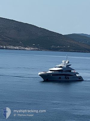
Yacht
Current Trip
I
| Time Travelled | 14 days |
|---|---|
| Remaining Time | --- |
| Distance Travelled | 83.43 nm |
| Remaining Distance | --- |
| AVG Speed | 8.2 Knots |
| MAX Speed | 11.6 Knots |
| AVG Wind | 5.1 knots |
| MAX Wind | 15.6 knots |
| MIN Temp | 13.2°C / 55.76°F |
| MAX Temp | 24.1°C / 75.38°F |
| Draught | 3.4 m |
| Position Received | 4 d ago |
Current Position
| Longitude | 7.92927° |
|---|---|
| Latitude | 43.82700° |
| Status | Under way using engine |
| Speed | 10.8 Knots |
| Course | 67.3° |
| Area | Ligurian Sea |
| Station | T-AIS |
| Position Received | 4 d ago |
Info
Information
The current position of INCEPTION is in Ligurian Sea with coordinates 43.82700° / 7.92927° as reported on 2024-05-30 13:38 by AIS to our vessel tracker app. The vessel's current speed is 10.8 Knots
The vessel INCEPTION (IMO: 1009704, MMSI: 232034192) is a Yacht that was built in 2008 ( 16 years old ). It's sailing under the flag of [GB] United Kingdom.
In this page you can find informations about the vessels current position, last detected port calls, and current voyage information. If the vessels is not in coverage by AIS you will find the latest position.
The current position of INCEPTION is detected by our AIS receivers and we are not responsible for the reliability of the data. The last position was recorded while the vessel was in Coverage by the Ais receivers of our vessel tracking app.
The current draught of INCEPTION as reported by AIS is 3.4 meters
Weather
| Temperature | 20°C / 68°F |
|---|---|
| Wind Speed | 3 knots |
| Direction | 15° NNE |
| Pressure | 1005 hPa |
| Humidity | 77 % |
| Cloud Coverage | 98 % |
Featured Company
Last Port Calls
| Port | Arrival | Departure | Time In Port |
|---|---|---|---|
| 2024-05-20 07:14 | |||
| 2024-04-14 17:25 | 2024-05-01 09:57 | 16 d | |
| 2024-04-10 08:10 | 2024-04-13 11:11 | 3 d | |
| 2024-04-10 07:33 |
Most Visited Ports (Last year)
| Port | Arrivals | |
|---|---|---|
| 7 | ||
| 6 | ||
| 2 | ||
| 2 | ||
| 1 | ||
| 1 |
Last Trips
| Origin | Departure | Destination | Arrival | Distance | |
|---|---|---|---|---|---|
| 2024-04-13 13:11 | 2024-04-14 19:25 | 351.26 nm | |||
| 2024-04-10 09:33 | 2024-04-10 10:10 | 4.41 nm |
Events
| Time | Event | Details | Position / Dest | Info |
|---|---|---|---|---|
| 2024-05-30 13:38 | OUT of Coverage |
43.82700 / 7.92927
Ligurian Sea
|
Speed: 10.8 kn Course: 67.3° |
|
| 2024-05-30 12:23 | Detected in Sea | Italian part of the Ligurian Sea |
43.75123 / 7.62556
Ligurian Sea
|
Speed: 11.2 kn Course: 73.9° |
| 2024-05-30 12:05 | Detected in Sea | Italian part of the Mediterranean Sea - Western Basin |
43.73522 / 7.55088
Mediterranean Sea - Western Basin
|
Speed: 10.9 kn Course: 73° |
| 2024-05-30 11:44 | Change Sea Area | French part of the Mediterranean Sea - Western Basin Mon�gasque part of the Mediterranean Sea - Western Basin |
43.71764 / 7.46585
Mediterranean Sea - Western Basin
|
Speed: 11.1 kn Course: 76.6° |
| 2024-05-30 11:35 | Change Sea Area | Mon�gasque part of the Mediterranean Sea - Western Basin French part of the Mediterranean Sea - Western Basin |
43.71126 / 7.42907
Mediterranean Sea - Western Basin
|
Speed: 10.9 kn Course: 77.3° |
| 2024-05-30 11:06 | START Moving | 0.46 nm, South East of BEAULIEU-SUR-MER |
43.70099 / 7.34240
I
|
Speed: 3.2 kn Course: 110° |
| 2024-05-30 11:02 | Status Changed | Under way using engine At anchor |
43.70173 / 7.34116
I
|
Speed: 0.4 kn Course: 158° |
| 2024-05-27 07:50 | Status Changed | At anchor Under way using engine |
43.70009 / 7.33925
I
|
Speed: 0.8 kn Course: 88° |
| 2024-05-27 07:46 | STOP Moving | 0.47 nm, South of BEAULIEU-SUR-MER |
43.70016 / 7.34010
I
|
Speed: 0.3 kn Course: 92° |
| 2024-05-27 07:10 | Change Sea Area | French part of the Mediterranean Sea - Western Basin Mon�gasque part of the Mediterranean Sea - Western Basin |
43.71698 / 7.42181
Mediterranean Sea - Western Basin
|
Speed: 10.2 kn Course: 231.7° |