
INGA A
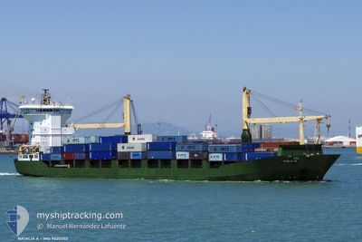
Container Ship
Current Trip
| Time Travelled | 2 days |
|---|---|
| Remaining Time | 9 h, 38 mins |
| Distance Travelled | 517.32 nm |
| Remaining Distance | 544.87 nm |
| AVG Speed | 9 Knots |
| MAX Speed | 11.4 Knots |
| AVG Wind | 4.1 knots |
| MAX Wind | 14.1 knots |
| MIN Temp | 15.6°C / 60.08°F |
| MAX Temp | 19.7°C / 67.46°F |
| Draught | 7.5 m |
| Position Received | 1 d ago |
Current Position
| Longitude | 29.86711° |
|---|---|
| Latitude | 41.49979° |
| Status | Under way using engine |
| Speed | 10.7 Knots |
| Course | 74.9° |
| Area | Black Sea |
| Station | T-AIS |
| Position Received | 1 d ago |
Info
Information
The current position of INGA A is in Black Sea with coordinates 41.49979° / 29.86711° as reported on 2024-05-29 09:17 by AIS to our vessel tracker app. The vessel's current speed is 10.7 Knots and is heading at the port of POTI. The estimated time of arrival as calculated by vessel tracking app is 2024-05-31 13:21 LT
The vessel INGA A (IMO: 9020352, MMSI: 271042494) is a Container Ship that was built in 1993 ( 31 years old ). It's sailing under the flag of [TR] Turkey.
In this page you can find informations about the vessels current position, last detected port calls, and current voyage information. If the vessels is not in coverage by AIS you will find the latest position.
The current position of INGA A is detected by our AIS receivers and we are not responsible for the reliability of the data. The last position was recorded while the vessel was in Coverage by the Ais receivers of our vessel tracking app.
The current draught of INGA A as reported by AIS is 7.5 meters
Weather
| Temperature | 19.3°C / 66.74°F |
|---|---|
| Wind Speed | 6 knots |
| Direction | 319° NW |
| Pressure | 1012.6 hPa |
| Humidity | 84 % |
| Cloud Coverage | 52 % |
Featured Company
Last Port Calls
| Port | Arrival | Departure | Time In Port |
|---|---|---|---|
| 2024-05-27 07:43 | 2024-05-28 13:11 | 1 d | |
| 2024-05-23 04:24 | 2024-05-24 15:36 | 1 d | |
| 2024-05-18 16:44 | 2024-05-20 08:31 | 1 d | |
| 2024-05-13 04:20 | 2024-05-15 09:08 | 2 d | |
| 2024-05-07 10:35 | 2024-05-08 11:31 | 1 d | |
| 2024-04-28 18:15 | 2024-04-29 03:49 | 9 h | |
| 2024-04-27 03:02 | 2024-04-27 20:45 | 17 h | |
| 2024-04-23 07:52 | 2024-04-24 19:25 | 1 d | |
| 2024-04-22 01:37 | |||
| 2024-04-21 20:21 | 2024-04-22 01:32 | 5 h |
Last Trips
| Origin | Departure | Destination | Arrival | Distance | |
|---|---|---|---|---|---|
| 2024-05-24 19:36 | 2024-05-27 10:43 | 620.09 nm | |||
| 2024-05-20 11:31 | 2024-05-23 08:24 | 635.48 nm | |||
| 2024-05-15 13:08 | 2024-05-18 19:44 | 652.91 nm | |||
| 2024-05-08 14:31 | 2024-05-13 08:20 | 703.51 nm | |||
| 2024-04-29 06:49 | 2024-05-07 13:35 | 881.37 nm | |||
| 2024-04-27 23:45 | 2024-04-28 21:15 | 86.20 nm | |||
| 2024-04-24 22:25 | 2024-04-27 06:02 | 320.70 nm | |||
| 2024-04-22 04:32 | 2024-04-22 04:37 | 2.71 nm | |||
| 2024-04-20 14:48 | 2024-04-21 23:21 | 394.93 nm | |||
| 2024-04-15 06:49 | 2024-04-18 07:01 | 638.97 nm |
Events
| Time | Event | Details | Position / Dest | Info |
|---|---|---|---|---|
| 2024-05-29 09:22 | Status Changed | Default Under way using engine |
41.50361 / 29.88693
GEPTI
|
Speed: 10.7 kn Course: 74.9° |
| 2024-05-29 09:17 | OUT of Coverage |
41.49979 / 29.86711
Black Sea
GEPTI
|
Speed: 10.7 kn Course: 74.9° |
|
| 2024-05-29 05:44 | Change Sea Area | Turkish part of the Black Sea Turkish part of the Sea of Marmara |
41.23182 / 29.14379
Black Sea
GEPTI
|
Speed: 9.8 kn Course: 45.1° |
| 2024-05-29 01:31 | START Moving | 12.74 nm, South of YESILKOY |
40.74531 / 28.86686
GEPTI
|
Speed: 3.4 kn Course: 4° |
| 2024-05-28 15:41 | STOP Moving | 10.52 nm, South of YESILKOY |
40.78140 / 28.85588
GEPTI
|
Speed: 0.3 kn Course: 343° |
| 2024-05-28 13:11 | PORT DEPARTURE |
|
40.95889 / 28.68582
GEPTI
|
Speed: 3.6 kn Course: 174° |
| 2024-05-28 13:08 | START Moving |
40.96049 / 28.68325
[TR] AMBARLI
|
Speed: 3.4 kn Course: 126° |
|
| 2024-05-28 12:53 | Status Changed | Under way using engine Moored |
40.96508 / 28.68387
[TR] AMBARLI
|
Speed: Course: 357° |
| 2024-05-28 12:15 | Draught Changed | 7.5 6.1 |
40.96503 / 28.68386
[TR] AMBARLI
|
Speed: Course: 357° |
| 2024-05-28 09:37 | Destination Changed | GEPTI TRAMB |
40.96507 / 28.68385
[TR] AMBARLI
|
Speed: Course: 357° |