
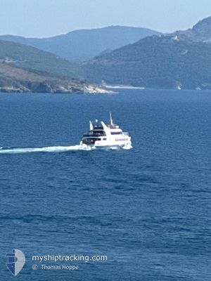
IONIAN SUN
Passengers Ship
Current Trip
CORFU SARANDA CORFU
| Time Travelled | 1 h, 1 mins |
|---|---|
| Remaining Time | --- |
| Distance Travelled | 2.66 nm |
| Remaining Distance | --- |
| AVG Speed | --- |
| MAX Speed | --- |
| AVG Wind | 6.1 knots |
| MAX Wind | 6.1 knots |
| MIN Temp | 24.3°C / 75.74°F |
| MAX Temp | 24.3°C / 75.74°F |
| Draught | 2.2 m |
| Position Received | 49 m ago |
Current Position
| Longitude | 19.99986° |
|---|---|
| Latitude | 39.81899° |
| Status | Under way using engine |
| Speed | 14 Knots |
| Course | 197° |
| Area | Adriatic Sea |
| Station | T-AIS |
| Position Received | 49 m ago |
Info
Information
The current position of IONIAN SUN is in Adriatic Sea with coordinates 39.81899° / 19.99986° as reported on 2024-06-17 14:12 by AIS to our vessel tracker app. The vessel's current speed is 14 Knots
The vessel IONIAN SUN (IMO: 8862014, MMSI: 201100185) is a Passengers Ship that was built in 1991 ( 33 years old ). It's sailing under the flag of [AL] Albania.
In this page you can find informations about the vessels current position, last detected port calls, and current voyage information. If the vessels is not in coverage by AIS you will find the latest position.
The current position of IONIAN SUN is detected by our AIS receivers and we are not responsible for the reliability of the data. The last position was recorded while the vessel was in Coverage by the Ais receivers of our vessel tracking app.
The current draught of IONIAN SUN as reported by AIS is 2.2 meters
Weather
| Temperature | 24.3°C / 75.74°F |
|---|---|
| Wind Speed | 6 knots |
| Direction | 323° NW |
| Pressure | 1014.4 hPa |
| Humidity | 57.8 % |
| Cloud Coverage | 10 % |
Featured Company
Last Port Calls
| Port | Arrival | Departure | Time In Port |
|---|---|---|---|
| 2024-06-17 12:51 | 2024-06-17 14:00 | 1 h | |
| 2024-06-17 08:47 | 2024-06-17 09:13 | 25 m | |
| 2024-06-16 17:52 | 2024-06-17 07:19 | 13 h | |
| 2024-06-16 11:24 | 2024-06-16 14:02 | 2 h | |
| 2024-06-16 09:13 | 2024-06-16 10:20 | 1 h | |
| 2024-06-16 07:20 | 2024-06-16 08:06 | 46 m | |
| 2024-06-16 05:09 | 2024-06-16 06:15 | 1 h | |
| 2024-06-15 17:14 | 2024-06-16 04:06 | 10 h | |
| 2024-06-15 15:03 | 2024-06-15 16:04 | 1 h | |
| 2024-06-15 11:36 | 2024-06-15 13:55 | 2 h |
Last Trips
| Origin | Departure | Destination | Arrival | Distance | |
|---|---|---|---|---|---|
| 2024-06-17 11:13 | 2024-06-17 14:51 | 29.29 nm | |||
| 2024-06-17 09:19 | 2024-06-17 10:47 | 19.17 nm | |||
| 2024-06-16 16:02 | 2024-06-16 19:52 | 24.67 nm | |||
| 2024-06-16 13:20 | 2024-06-16 13:24 | 11.43 nm | |||
| 2024-06-16 10:06 | 2024-06-16 12:13 | 14.87 nm | |||
| 2024-06-16 09:15 | 2024-06-16 09:20 | 4.66 nm | |||
| 2024-06-16 06:06 | 2024-06-16 08:09 | 14.38 nm | |||
| 2024-06-15 19:04 | 2024-06-15 19:14 | 10.18 nm | |||
| 2024-06-15 15:55 | 2024-06-15 18:03 | 13.12 nm | |||
| 2024-06-15 10:04 | 2024-06-15 13:36 | 7.23 nm |
Events
| Time | Event | Details | Position / Dest | Info |
|---|---|---|---|---|
| 2024-06-17 14:19 | Status Changed | Default Under way using engine |
39.79036 / 19.98618
CORFU SARANDA CORFU
|
Speed: 14 kn Course: 197° |
| 2024-06-17 14:00 | PORT DEPARTURE |
|
39.86227 / 20.00973
CORFU SARANDA CORFU
|
Speed: 13.6 kn Course: 165.8° |
| 2024-06-17 13:58 | START Moving |
39.86944 / 20.00690
[AL] SARANDE
|
Speed: 10.1 kn Course: 155.3° |
|
| 2024-06-17 12:56 | STOP Moving |
39.87126 / 20.00559
[AL] SARANDE
|
Speed: 0.3 kn Course: 511° |
|
| 2024-06-17 12:51 | PORT ARRIVAL |
|
39.86512 / 20.00647
[AL] SARANDE
|
Speed: 13.5 kn Course: 357.3° |
| 2024-06-17 12:28 | Change Sea Area | Albanian part of the Adriatic Sea Greek part of the Adriatic Sea |
39.78021 / 19.97657
Adriatic Sea
|
Speed: 13.7 kn Course: 31.6° |
| 2024-06-17 12:19 | IN Coverage |
39.75171 / 19.95788
Adriatic Sea
|
Speed: 13.4 kn Course: 18.7° |
|
| 2024-06-17 10:49 | OUT of Coverage |
39.77453 / 19.96043
Adriatic Sea
|
Speed: 13.9 kn Course: 165.1° |
|
| 2024-06-17 10:28 | Detected in Sea | Greek part of the Adriatic Sea |
39.84587 / 19.91120
Adriatic Sea
|
Speed: 14.2 kn Course: 153.2° |
| 2024-06-17 10:28 | Status Changed | Under way using engine Default |
39.84587 / 19.91120
CORFU SARANDA CORFU
|
Speed: 13.8 kn Course: 154° |