
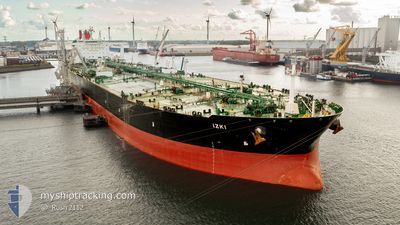
IZKI
Crude Oil Tanker
Current Trip
| Time Travelled | 13 days |
|---|---|
| Remaining Time | --- |
| Distance Travelled | 1586.53 nm |
| Remaining Distance | --- |
| AVG Speed | 10 Knots |
| MAX Speed | 13.9 Knots |
| AVG Wind | 9 knots |
| MAX Wind | 37.4 knots |
| MIN Temp | 19.1°C / 66.38°F |
| MAX Temp | 28.8°C / 83.84°F |
| Draught | 11 m |
| Position Received | 2 d ago |
Current Position
| Longitude | 124.01927° |
|---|---|
| Latitude | 34.49058° |
| Status | Under way using engine |
| Speed | 10.8 Knots |
| Course | 179.7° |
| Area | Yellow Sea |
| Station | T-AIS |
| Position Received | 2 d ago |
Info
Information
The current position of IZKI is in Yellow Sea with coordinates 34.49058° / 124.01927° as reported on 2024-06-26 12:44 by AIS to our vessel tracker app. The vessel's current speed is 10.8 Knots and is heading at the port of SINGAPORE. The estimated time of arrival as calculated by vessel tracking app is 2024-07-06 02:00 LT
The vessel IZKI (IMO: 9500924, MMSI: 538004578) is a Crude Oil Tanker that was built in 2012 ( 12 years old ). It's sailing under the flag of [MH] Marshall Is.
In this page you can find informations about the vessels current position, last detected port calls, and current voyage information. If the vessels is not in coverage by AIS you will find the latest position.
The current position of IZKI is detected by our AIS receivers and we are not responsible for the reliability of the data. The last position was recorded while the vessel was in Coverage by the Ais receivers of our vessel tracking app.
The current draught of IZKI as reported by AIS is 11 meters
Weather
| Temperature | 28.8°C / 83.84°F |
|---|---|
| Wind Speed | 17 knots |
| Direction | 195° SSW |
| Pressure | 1008.7 hPa |
| Humidity | 86.8 % |
| Cloud Coverage | 94 % |
Featured Company
Last Port Calls
| Port | Arrival | Departure | Time In Port |
|---|---|---|---|
| 2024-06-14 03:45 | 2024-06-14 23:57 | 20 h | |
| 2024-05-16 09:27 | |||
| 2024-04-30 01:08 | 2024-05-01 03:22 | 1 d | |
| 2024-04-24 18:50 | 2024-04-26 00:14 | 1 d | |
| 2024-04-19 14:56 | 2024-04-23 15:00 | 4 d |
Most Visited Ports (Last year)
| Port | Arrivals | |
|---|---|---|
| 3 | ||
| 2 | ||
| 1 | ||
| 1 | ||
| 1 | ||
| 1 |
Last Trips
| Origin | Departure | Destination | Arrival | Distance | |
|---|---|---|---|---|---|
| 2024-04-30 20:22 | 2024-05-16 04:27 | 3186.64 nm | |||
| 2024-04-25 17:14 | 2024-04-29 18:08 | 95.04 nm | |||
| 2024-04-23 08:00 | 2024-04-24 11:50 | 9.27 nm |
Events
| Time | Event | Details | Position / Dest | Info |
|---|---|---|---|---|
| 2024-06-26 12:49 | Status Changed | Default Under way using engine |
34.47545 / 124.01901
CN YNT>SG SIN
|
Speed: 10.8 kn Course: 179.7° |
| 2024-06-26 12:44 | OUT of Coverage |
34.49058 / 124.01927
Yellow Sea
CN YNT>SG SIN
|
Speed: 10.8 kn Course: 179.7° |
|
| 2024-06-26 12:34 | IN Coverage |
34.52107 / 124.01949
Yellow Sea
CN YNT>SG SIN
|
Speed: 10.7 kn Course: 178.5° |
|
| 2024-06-26 12:32 | Status Changed | Under way using engine Default |
34.52740 / 124.01929
CN YNT>SG SIN
|
Speed: 10.6 kn Course: 178° |
| 2024-06-26 04:53 | Status Changed | Default Under way using engine |
35.78467 / 124.02457
CN YNT>SG SIN
|
Speed: 10.1 kn Course: 180.5° |
| 2024-06-26 04:50 | OUT of Coverage |
35.79410 / 124.02483
Yellow Sea
CN YNT>SG SIN
|
Speed: 10.1 kn Course: 180.5° |
|
| 2024-06-26 04:33 | Status Changed | Under way using engine Default |
35.84274 / 124.02647
CN YNT>SG SIN
|
Speed: 10.2 kn Course: 181° |
| 2024-06-26 04:26 | IN Coverage |
35.83745 / 124.02624
Yellow Sea
CN YNT>SG SIN
|
Speed: 10.2 kn Course: 181.8° |
|
| 2024-06-26 03:02 | Status Changed | Default Under way using engine |
36.09261 / 123.97282
CN YNT>SG SIN
|
Speed: 10.3 kn Course: 147.8° |
| 2024-06-26 02:58 | OUT of Coverage |
36.10190 / 123.96569
Yellow Sea
CN YNT>SG SIN
|
Speed: 10.3 kn Course: 147.8° |