
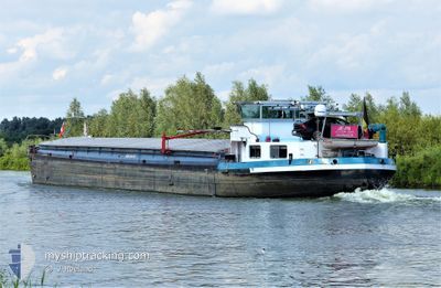
JE-PA
Wing in ground
Current Trip
Current Position
| Longitude | 6.07916° |
|---|---|
| Latitude | 51.54288° |
| Status | Moored |
| Speed | |
| Course | --- |
| Area | North Sea |
| Station | T-AIS |
| Position Received | 3 m ago |
Info
Information
The current position of JE-PA is in North Sea with coordinates 51.54288° / 6.07916° as reported on 2024-06-20 21:10 by AIS to our vessel tracker app. The vessel's current speed is 0 Knots and is currently inside the port of WANSSUM.
The vessel JE-PA (MMSI: 205218990) is a Wing in ground It's sailing under the flag of [BE] Belgium.
In this page you can find informations about the vessels current position, last detected port calls, and current voyage information. If the vessels is not in coverage by AIS you will find the latest position.
The current position of JE-PA is detected by our AIS receivers and we are not responsible for the reliability of the data. The last position was recorded while the vessel was in Coverage by the Ais receivers of our vessel tracking app.
Weather
| Temperature | 14.9°C / 58.82°F |
|---|---|
| Wind Speed | 5 knots |
| Direction | 6° N |
| Pressure | 1015.9 hPa |
| Humidity | 95.8 % |
| Cloud Coverage | 100 % |
Featured Company
Last Port Calls
| Port | Arrival | Departure | Time In Port |
|---|---|---|---|
| 2024-06-18 18:48 | |||
| 2024-06-11 10:23 | 2024-06-17 17:09 | 6 d | |
| 2024-06-06 13:04 | 2024-06-08 03:46 | 1 d | |
| 2024-06-05 07:42 | 2024-06-06 09:49 | 1 d | |
| 2024-06-04 11:53 | 2024-06-04 17:57 | 6 h | |
| 2024-06-01 13:11 | 2024-06-04 06:56 | 2 d | |
| 2024-05-24 18:02 | 2024-06-01 06:51 | 7 d | |
| 2024-05-23 14:52 | 2024-05-24 08:43 | 17 h | |
| 2024-04-23 17:14 | 2024-04-25 13:09 | 1 d | |
| 2024-04-19 07:37 | 2024-04-22 09:34 | 3 d |
Last Trips
| Origin | Departure | Destination | Arrival | Distance | |
|---|---|---|---|---|---|
| 2024-06-17 19:09 | 2024-06-18 20:48 | 101.45 nm | |||
| 2024-06-08 05:46 | 2024-06-11 12:23 | 205.80 nm | |||
| 2024-06-06 11:49 | 2024-06-06 15:04 | 18.44 nm | |||
| 2024-06-04 19:57 | 2024-06-05 09:42 | 18.85 nm | |||
| 2024-06-04 08:56 | 2024-06-04 13:53 | 32.96 nm | |||
| 2024-06-01 08:51 | 2024-06-01 15:11 | 43.77 nm | |||
| 2024-05-24 10:43 | 2024-05-24 20:02 | 50.11 nm | |||
| 2024-04-25 15:09 | 2024-05-23 16:52 | 148.65 nm | |||
| 2024-04-22 11:34 | 2024-04-23 19:14 | 41.03 nm | |||
| 2024-04-19 08:51 | 2024-04-19 09:37 | 5.62 nm |
Events
| Time | Event | Details | Position / Dest | Info |
|---|---|---|---|---|
| 2024-06-20 18:32 | OUT of Coverage |
51.54291 / 6.07923
North Sea
[NL] WANSSUM
|
Speed: Course: 74.9° |
|
| 2024-06-20 18:22 | IN Coverage |
51.54292 / 6.07929
North Sea
[NL] WANSSUM
|
Speed: Course: 148.8° |
|
| 2024-06-19 02:34 | OUT of Coverage |
51.54203 / 6.07931
North Sea
[NL] WANSSUM
|
Speed: Course: 245.2° |
|
| 2024-06-19 02:34 | IN Coverage |
51.54203 / 6.07931
North Sea
[NL] WANSSUM
|
Speed: Course: 245.2° |
|
| 2024-06-18 18:48 | PORT ARRIVAL |
|
51.54203 / 6.07931
[NL] WANSSUM
|
Speed: 6.1 kn Course: 129.7° |
| 2024-06-18 18:43 | OUT of Coverage |
51.54995 / 6.07159
North Sea
WANSUM
|
Speed: 6.1 kn Course: 129.7° |
|
| 2024-06-18 17:36 | START Moving | 2.07 nm, South East of BOXMEER |
51.63905 / 5.98485
WANSUM
|
Speed: 5 kn Course: 120.4° |
| 2024-06-18 17:34 | Status Changed | Under way using engine Moored |
51.64008 / 5.98208
WANSUM
|
Speed: 0.1 kn Course: 511° |
| 2024-06-18 17:25 | Status Changed | Moored Under way using engine |
51.64018 / 5.98172
WANSUM
|
Speed: 1.6 kn Course: 511° |
| 2024-06-18 17:25 | STOP Moving | 1.95 nm, South East of BOXMEER |
51.64018 / 5.98172
WANSUM
|
Speed: Course: 511° |