
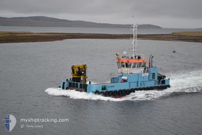
JIF MAIRI
Tug
Current Trip
WESTRAY
| Time Travelled | 57 mins |
|---|---|
| Remaining Time | --- |
| Distance Travelled | 3.93 nm |
| Remaining Distance | --- |
| AVG Speed | 6.8 Knots |
| MAX Speed | 6.9 Knots |
| AVG Wind | 11.6 knots |
| MAX Wind | 12.4 knots |
| MIN Temp | 10.8°C / 51.44°F |
| MAX Temp | 11°C / 51.8°F |
| Draught | 2.2 m |
| Position Received | 12 h, 49 m ago |
Current Position
| Longitude | -2.81813° |
|---|---|
| Latitude | 59.24715° |
| Status | Under way using engine |
| Speed | 9.4 Knots |
| Course | 352.2° |
| Area | North Atlantic Ocean |
| Station | T-AIS |
| Position Received | 12 h, 49 m ago |
Info
Information
The current position of JIF MAIRI is in North Atlantic Ocean with coordinates 59.24715° / -2.81813° as reported on 2024-05-28 18:51 by AIS to our vessel tracker app. The vessel's current speed is 9.4 Knots
The vessel JIF MAIRI (IMO: 9923918, MMSI: 232033759) is a Tug It's sailing under the flag of [GB] United Kingdom.
In this page you can find informations about the vessels current position, last detected port calls, and current voyage information. If the vessels is not in coverage by AIS you will find the latest position.
The current position of JIF MAIRI is detected by our AIS receivers and we are not responsible for the reliability of the data. The last position was recorded while the vessel was in Coverage by the Ais receivers of our vessel tracking app.
The current draught of JIF MAIRI as reported by AIS is 2.2 meters
Weather
| Temperature | 11°C / 51.8°F |
|---|---|
| Wind Speed | 11 knots |
| Direction | 118° ESE |
| Pressure | 1005.1 hPa |
| Humidity | 93.2 % |
| Cloud Coverage | 100 % |
Featured Company
Last Port Calls
| Port | Arrival | Departure | Time In Port |
|---|---|---|---|
| 2024-05-28 20:23 | 2024-05-29 06:44 | 10 h | |
| 2024-05-27 21:16 | 2024-05-28 16:23 | 19 h | |
| 2024-05-27 10:43 | 2024-05-27 12:11 | 1 h | |
| 2024-05-26 16:39 | 2024-05-27 05:43 | 13 h | |
| 2024-05-26 09:35 | 2024-05-26 10:03 | 27 m | |
| 2024-05-25 17:30 | 2024-05-26 06:55 | 13 h | |
| 2024-05-25 13:31 | 2024-05-25 14:42 | 1 h | |
| 2024-05-24 18:26 | 2024-05-25 06:34 | 12 h | |
| 2024-05-24 13:17 | 2024-05-24 14:18 | 1 h | |
| 2024-05-24 08:22 | 2024-05-24 09:26 | 1 h |
Last Trips
| Origin | Departure | Destination | Arrival | Distance | |
|---|---|---|---|---|---|
| 2024-05-28 17:23 | 2024-05-28 21:23 | 27.67 nm | |||
| 2024-05-27 13:11 | 2024-05-27 22:16 | 28.19 nm | |||
| 2024-05-27 06:43 | 2024-05-27 11:43 | 8.71 nm | |||
| 2024-05-26 11:03 | 2024-05-26 17:39 | 9.17 nm | |||
| 2024-05-26 07:55 | 2024-05-26 10:35 | 10.97 nm | |||
| 2024-05-25 15:42 | 2024-05-25 18:30 | 8.00 nm | |||
| 2024-05-25 07:34 | 2024-05-25 14:31 | 8.90 nm | |||
| 2024-05-24 15:18 | 2024-05-24 19:26 | 8.84 nm | |||
| 2024-05-24 10:26 | 2024-05-24 14:17 | 8.34 nm | |||
| 2024-05-24 06:18 | 2024-05-24 09:22 | 6.75 nm |
Events
| Time | Event | Details | Position / Dest | Info |
|---|---|---|---|---|
| 2024-05-29 07:24 | STOP Moving | 1.92 nm, East of PAPA WESTRAY |
59.32031 / -2.83174
WESTRAY
|
Speed: 0.3 kn Course: 140° |
| 2024-05-29 06:44 | START Moving | 0.43 nm, East of PAPA WESTRAY |
59.32288 / -2.95844
WESTRAY
|
Speed: 7 kn Course: 96° |
| 2024-05-29 06:44 | PORT DEPARTURE |
|
59.32288 / -2.95844
WESTRAY
|
Speed: 6.3 kn Course: 86° |
| 2024-05-28 20:23 | STOP Moving |
59.32275 / -2.97644
[GB] PAPA WESTRAY
|
Speed: 0.2 kn Course: 306° |
|
| 2024-05-28 20:23 | PORT ARRIVAL |
|
59.32275 / -2.97644
[GB] PAPA WESTRAY
|
Speed: 9.1 kn Course: 265° |
| 2024-05-28 18:56 | Status Changed | Default Under way using engine |
59.25841 / -2.82090
WESTRAY
|
Speed: 9.4 kn Course: 352.2° |
| 2024-05-28 18:51 | OUT of Coverage |
59.24715 / -2.81813
North Atlantic Ocean
|
Speed: 9.4 kn Course: 352.2° |
|
| 2024-05-28 18:20 | Change Sea Area | United Kingdom part of the North Atlantic Ocean United Kingdom part of the North Sea |
59.17582 / -2.85598
North Atlantic Ocean
|
Speed: 12.1 kn Course: 17.8° |
| 2024-05-28 17:45 | START Moving | 1.13 nm, North East of WYRE |
59.13283 / -2.93980
WESTRAY
|
Speed: 6.4 kn Course: 169° |
| 2024-05-28 17:13 | STOP Moving | 1.24 nm, South of EGILSAY |
59.13413 / -2.93710
WESTRAY
|
Speed: 0.3 kn Course: 319° |