
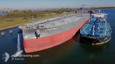
JULIUS CAESAR
Tanker
Current Trip
SGSIN>AODAL
| Time Travelled | --- |
|---|---|
| Remaining Time | --- |
| Distance Travelled | 9499.65 nm |
| Remaining Distance | --- |
| AVG Speed | 10.9 Knots |
| MAX Speed | 14.7 Knots |
| AVG Wind | 11.1 knots |
| MAX Wind | 31 knots |
| MIN Temp | 15.8°C / 60.44°F |
| MAX Temp | 30.9°C / 87.62°F |
| Draught | 11 m |
| Position Received | 23 d ago |
Current Position
| Longitude | 17.52428° |
|---|---|
| Latitude | -33.87886° |
| Status | Under way using engine |
| Speed | 11.9 Knots |
| Course | 325.9° |
| Area | South Atlantic Ocean |
| Station | T-AIS |
| Position Received | 23 d ago |
Info
Information
The current position of JULIUS CAESAR is in South Atlantic Ocean with coordinates -33.87886° / 17.52428° as reported on 2024-05-24 04:45 by AIS to our vessel tracker app. The vessel's current speed is 11.9 Knots
The vessel JULIUS CAESAR (IMO: 9912244, MMSI: 538009643) is a Tanker It's sailing under the flag of [MH] Marshall Is.
In this page you can find informations about the vessels current position, last detected port calls, and current voyage information. If the vessels is not in coverage by AIS you will find the latest position.
The current position of JULIUS CAESAR is detected by our AIS receivers and we are not responsible for the reliability of the data. The last position was recorded while the vessel was in Coverage by the Ais receivers of our vessel tracking app.
The current draught of JULIUS CAESAR as reported by AIS is 11 meters
Weather
| Temperature | 17.8°C / 64.04°F |
|---|---|
| Wind Speed | 11 knots |
| Direction | 259° W |
| Pressure | 1012.5 hPa |
| Humidity | 89.4 % |
| Cloud Coverage | --- |
Featured Company
Last Port Calls
| Port | Arrival | Departure | Time In Port |
|---|---|---|---|
| 2024-04-01 00:35 |
Most Visited Ports (Last year)
| Port | Arrivals | |
|---|---|---|
| 2 | ||
| 2 | ||
| 1 |
Last Trips
| Origin | Departure | Destination | Arrival | Distance |
|---|
Events
| Time | Event | Details | Position / Dest | Info |
|---|---|---|---|---|
| 2024-06-12 14:32 | START Moving |
-7.33808 / 11.38077
SGSIN>AODAL
|
Speed: 3.2 kn Course: 56° |
|
| 2024-06-11 08:06 | STOP Moving |
-7.35788 / 11.37432
SGSIN>AODAL
|
Speed: 0.2 kn Course: 174° |
|
| 2024-06-11 01:13 | START Moving |
-7.35046 / 11.07644
SGSIN>AODAL
|
Speed: 3.1 kn Course: 93° |
|
| 2024-06-10 21:59 | STOP Moving |
-7.40164 / 11.05138
SGSIN>AODAL
|
Speed: 0.3 kn Course: 160° |
|
| 2024-06-10 20:24 | START Moving |
-7.27128 / 10.95829
SGSIN>AODAL
|
Speed: 3.3 kn Course: 140° |
|
| 2024-06-10 02:26 | STOP Moving |
-7.50703 / 10.88759
SGSIN>AODAL
|
Speed: 0.3 kn Course: 164° |
|
| 2024-06-09 06:03 | START Moving |
-7.22733 / 11.01284
SGSIN>AODAL
|
Speed: 3.8 kn Course: 200° |
|
| 2024-06-08 15:16 | STOP Moving |
-7.42623 / 10.91661
SGSIN>AODAL
|
Speed: 0.3 kn Course: 143° |
|
| 2024-06-08 14:39 | START Moving |
-7.41679 / 10.89238
SGSIN>AODAL
|
Speed: 3.3 kn Course: 103° |
|
| 2024-06-08 08:43 | STOP Moving |
-7.46526 / 10.87930
SGSIN>AODAL
|
Speed: 0.3 kn Course: 254° |