
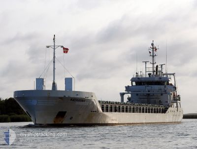
KATARIINA
General Cargo
Current Trip
| Time Travelled | 1 day |
|---|---|
| Remaining Time | 16 h, 11 mins |
| Distance Travelled | 449.46 nm |
| Remaining Distance | 202.68 nm |
| AVG Speed | 10.7 Knots |
| MAX Speed | 11.4 Knots |
| AVG Wind | 13.5 knots |
| MAX Wind | 19.6 knots |
| MIN Temp | 8.7°C / 47.66°F |
| MAX Temp | 17.9°C / 64.22°F |
| Draught | 5.1 m |
| Position Received | 11 m ago |
Current Position
| Longitude | 21.99547° |
|---|---|
| Latitude | 59.01601° |
| Status | Under way using engine |
| Speed | 11.1 Knots |
| Course | 53.2° |
| Area | Baltic Sea |
| Station | T-AIS |
| Position Received | 11 m ago |
Info
Information
The current position of KATARIINA is in Baltic Sea with coordinates 59.01601° / 21.99547° as reported on 2024-05-17 07:23 by AIS to our vessel tracker app. The vessel's current speed is 11.1 Knots and is heading at the port of HAMINA. The estimated time of arrival as calculated by vessel tracking app is 2024-05-17 23:46 LT
The vessel KATARIINA (IMO: 9467213, MMSI: 305211000) is a General Cargo that was built in 2011 ( 13 years old ). It's sailing under the flag of [AG] Antigua Barbuda.
In this page you can find informations about the vessels current position, last detected port calls, and current voyage information. If the vessels is not in coverage by AIS you will find the latest position.
The current position of KATARIINA is detected by our AIS receivers and we are not responsible for the reliability of the data. The last position was recorded while the vessel was in Coverage by the Ais receivers of our vessel tracking app.
The current draught of KATARIINA as reported by AIS is 5.1 meters
Weather
| Temperature | 8.8°C / 47.84°F |
|---|---|
| Wind Speed | 7 knots |
| Direction | 319° NW |
| Pressure | 1024.7 hPa |
| Humidity | 77.7 % |
| Cloud Coverage | 8 % |
Featured Company
Last Port Calls
| Port | Arrival | Departure | Time In Port |
|---|---|---|---|
| 2024-05-15 03:08 | 2024-05-15 14:04 | 10 h | |
| 2024-05-11 11:50 | 2024-05-14 13:19 | 3 d | |
| 2024-05-09 15:57 | 2024-05-10 16:08 | 1 d | |
| 2024-05-05 03:20 | 2024-05-06 12:20 | 1 d | |
| 2024-05-02 11:52 | 2024-05-03 08:44 | 20 h | |
| 2024-04-27 19:46 | 2024-04-28 22:49 | 1 d | |
| 2024-04-24 18:45 | 2024-04-26 19:20 | 2 d | |
| 2024-04-17 17:26 | 2024-04-20 04:39 | 2 d | |
| 2024-04-16 03:00 | 2024-04-16 14:28 | 11 h | |
| 2024-04-12 10:15 | 2024-04-14 06:26 | 1 d |
Last Trips
| Origin | Departure | Destination | Arrival | Distance | |
|---|---|---|---|---|---|
| 2024-05-14 15:19 | 2024-05-15 05:08 | 129.35 nm | |||
| 2024-05-10 18:08 | 2024-05-11 13:50 | 208.56 nm | |||
| 2024-05-06 15:20 | 2024-05-09 17:57 | 814.81 nm | |||
| 2024-05-03 10:44 | 2024-05-05 06:20 | 450.87 nm | |||
| 2024-04-29 00:49 | 2024-05-02 13:52 | 842.60 nm | |||
| 2024-04-26 20:20 | 2024-04-27 21:46 | 229.86 nm | |||
| 2024-04-20 06:39 | 2024-04-24 19:45 | 516.52 nm | |||
| 2024-04-16 16:28 | 2024-04-17 19:26 | 154.15 nm | |||
| 2024-04-14 09:26 | 2024-04-16 05:00 | 435.46 nm | |||
| 2024-04-10 10:28 | 2024-04-12 13:15 | 568.84 nm |
Events
| Time | Event | Details | Position / Dest | Info |
|---|---|---|---|---|
| 2024-05-17 07:15 | Change Sea Area | Estonian part of the Baltic Sea Swedish part of the Baltic Sea |
59.00071 / 21.95573
Baltic Sea
FIHMN
|
Speed: 10.9 kn Course: 53.2° |
| 2024-05-17 07:13 | Status Changed | Under way using engine Default |
58.99822 / 21.94933
FIHMN
|
Speed: 11 kn Course: 32° |
| 2024-05-17 07:13 | IN Coverage |
59.00071 / 21.95573
Baltic Sea
FIHMN
|
Speed: 10.9 kn Course: 53.2° |
|
| 2024-05-16 13:57 | Status Changed | Default Under way using engine |
56.59713 / 18.03555
FIHMN
|
Speed: 11.1 kn Course: 52.3° |
| 2024-05-16 13:49 | OUT of Coverage |
56.58338 / 18.00318
Baltic Sea
FIHMN
|
Speed: 11.1 kn Course: 52.3° |
|
| 2024-05-16 04:07 | Change Sea Area | Swedish part of the Baltic Sea Danish part of the Kattegat |
55.62034 / 15.38317
Baltic Sea
FIHMN
|
Speed: 10.7 kn Course: 59.9° |
| 2024-05-15 22:40 | Detected in Sea | Danish part of the Kattegat |
55.00045 / 14.05297
Kattegat
FIHMN
|
Speed: 10.6 kn Course: 67.1° |
| 2024-05-15 22:20 | Change Sea Area | Swedish part of the Baltic Sea German part of the Baltic Sea |
54.97696 / 13.95697
Baltic Sea
FIHMN
|
Speed: 10.9 kn Course: 67.2° |
| 2024-05-15 14:04 | PORT DEPARTURE |
|
54.19025 / 12.08801
FIHMN
|
Speed: 10.9 kn Course: 340° |
| 2024-05-15 13:28 | START Moving |
54.11663 / 12.09292
[DE] ROSTOCK
|
Speed: 5.5 kn Course: 49° |